North-central US to face dramatic temperature swings, occasional rain this week
A series of systems traversing through the north-central United States will set a temperature roller coaster ride in motion during the first days of October.
The brief cold snap at the end of last week should not have residents storing away summer clothes just yet.
"With the pattern we expect this week across the Plains and Midwest, temperatures will vary greatly from north to south over a relatively short distance," AccuWeather Senior Meteorologist Mike Doll said.
The pattern will make it necessary to wear a jacket one day and shorts and t-shirts the next.
Umbrellas will also be needed on occasion.
"There will be a few rounds of rain and thunderstorms throughout the week that can cause travel delays and disrupt outdoor activities," Doll said.
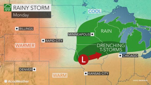
The first system to sweep through the region will make for a dreary weather into the start of October across the upper Mississippi Valley and Great Lakes.
Pockets of rain and thunderstorms are expected to set up along a corridor from southern Minnesota and Iowa to Michigan into Monday evening.
Localized flooding is possible along this corridor, especially since the region has experienced an excess of rainfall over the past two months.
This includes around Madison, Wisconsin, where both the morning and evening commutes could be slowed by wet weather on Monday. Motorists may be forced to detour around some flooded roads.
If enough sunshine breaks out between the downpours, a few heavy and gusty storms cannot be ruled out across eastern Iowa, southern Wisconsin and northern Illinois on Monday afternoon.
As the downpours exit the area and sweep into the Northeast on Tuesday, warmth will be on the rebound across the nation's midsection.
High temperatures on Wednesday are forecast to be 10-25 degrees Fahrenheit above Monday's highs in Omaha, Nebraska; Des Moines, Iowa; Madison and Green Bay, Wisconsin; and Minneapolis.
Widespread 70s and 80s are in store across this corridor, which are levels more typical of the end of August and early September.
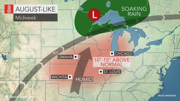
Near-record heat will broil areas to the south, including St. Louis where the mercury may surpass 90 F at midweek.
The midweek warmth will be pulled northward ahead of a second system set to sweep through the northern Plains and Upper Midwest with soaking rain.
A new wave of chilly air will sweep in by Thursday, with highs dropping back into the 40s, 50s and 60s across the north-central states.
Yet another surge of rain with milder air to the south is expected to arrive by the end of the week.
"This wet pattern is not good news for farmers looking to harvest their crops," Doll said.
"Fields across parts of Minnesota and Wisconsin are already too muddy for harvesting and additional rain will cause more delays," he added.
Download the AccuWeather app to know exactly when rain will arrive in your area.
