Massive snowstorm cuts power to hundreds of thousands from Wisconsin to Maine

A storm delivered one of the heaviest snowfalls of the cold weather season for the northern portion of the northeastern United States, AccuWeather meteorologists say. While the April nor'easter had skiers jumping for joy, the storm caused problems in a region that generally embraces snow.
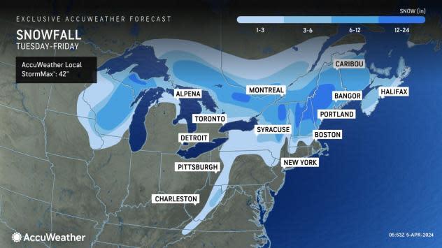
A storm back on March 23 dropped a general 6-24 inches of snow from northern New York to Maine. Snowfall from the new storm, projected well in advance by AccuWeather meteorologists, exceeded those amounts in some cases.
 |
An old storm responsible for heavy snow in Wisconsin got new life and rebounded as a strong nor'easter, unloading anywhere from 6 inches to 36 inches of heavy wet snow from Maine to New Hampshire, Vermont and northern New York state into Friday.
The AccuWeather Local StormMax™ snowfall for the budding April nor'easter is a whopping 42 inches and is most likely over the ridges and peaks of the Presidential Range, the Green Mountains and the Adirondacks.
"The wet and clinging nature of the snow will weigh down trees and power lines," AccuWeather Senior Meteorologist Joe Lundberg said.
 |
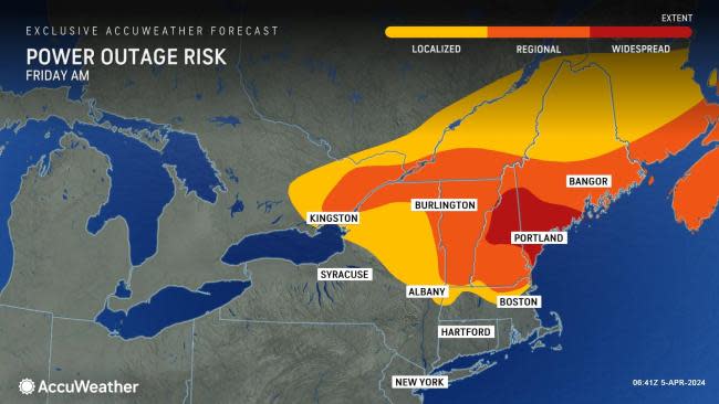
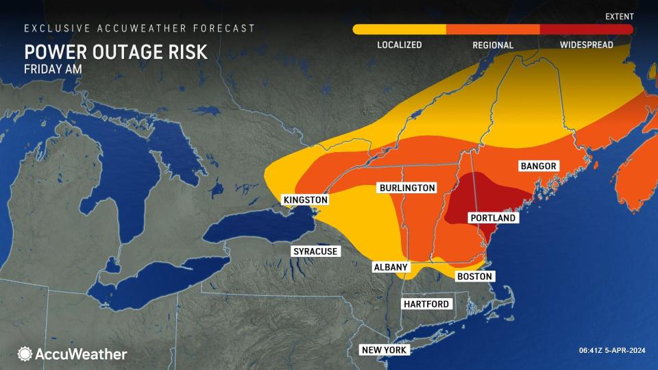
As winds increased and trees strained under the pressure, large limbs broke, taking power lines with them on Thursday, Lundberg explained. Power outages in the region may be extensive and long-lasting as it may be difficult for crews to get to all locations where trees and slushy snow block roads.
As of Friday morning, two-thirds of a million utility customers were without power due to snow-related problems from Wisconsin to Maine, according to PowerOutage.us. Nearly 350,000 were without power in Maine alone, where snow fell profusely in many areas. In Millinocket, Maine, the visibility dipped to near zero in heavy snow for a time on Thursday morning.
That number decreased through Thursday night and, as of Friday morning, just over 400,000 customers were without power. Over 250,000 of these customers were in Maine.
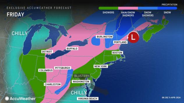
Snowfall had already topped the 1-foot mark in portions of Maine and the mountains of New Hampshire, Vermont and northeastern New York as of mid-afternoon on Thursday. Rain and snow showers will continue through Friday, accumulating an additional general coating to an inch across the mountains in the region.
 |
In much of the central Appalachians, all of the mid-Atlantic coast and the southern New England coast, temperatures were too high to allow any accumulating snow from the storm. Drenching rain caused its share of problems ranging from street and stream flooding to foiled outdoor plans through Wednesday night.
The combination of strong winds and tides will result in flooding in eastern New England into Friday, AccuWeather Meteorologist Dean DeVore said.
Water piled along the western end of Long Island Sound around New York City from Wednesday to Wednesday night, resulting in moderate coastal flooding around high tide.
The complex storm brought rain over several days from the Midwest to the mid-Atlantic region. A general 2-4 inches of rain fell from Illinois to Pennsylvania, New Jersey and the southern tier of New York. Even though the rain was spread out for many hours, it was prolific enough to push many small streams out of their banks and even trigger minor to moderate flooding on some of the rivers in the region. A portion of the Ohio River surged to major flood levels on Thursday.
Blustery and cold conditions will follow the storm for several days. Frost may make an appearance in parts of the interior South at the end of the week when winds diminish.
Want next-level safety, ad-free? Unlock advanced, hyperlocal severe weather alerts when you subscribe to Premium+ on the AccuWeather app. AccuWeather Alerts™ are prompted by our expert meteorologists who monitor and analyze dangerous weather risks 24/7 to keep you and your family safer.
