National Hurricane Center: No tropical activity expected over next 2 days. See Memorial Day forecast
The tropics continue to be quiet as we near the official start of the 2024 Atlantic hurricane season, according to the most recent tropical outlook issued by the National Hurricane Center.
No tropical cyclone activity is expected over the next 48 hours.
The quiet isn't expected to last, and the National Hurricane Center will issue its forecast for the 2024 season Thursday, May 23.
Ryan Truchelut, chief meteorologist at WeatherTiger and known to Florida residents for his weekly tropical overview columns and live forecasts whenever a storm threatens the Sunshine State, issued an updated hurricane season prediction this morning.
His updated forecast increases the number of expected storms to:
22-26 tropical storms
10-13 hurricanes
5-8 major hurricanes, which is a Category 3 storm or higher
an 80% chance of at least two U.S. hurricane landfalls in 2024
"The 2024 hurricane season is nearly certain to be more active than average and has a roughly 25% chance of being the busiest on record," Truchelut said.
Earlier predictions from AccuWeather and Colorado State University also predict the season will be very active due to the combination of La Niña and extremely warm water temperatures. Both favor the development of tropical cyclones.
While the official start of hurricane season is June 1, tropical storms and hurricanes have formed earlier. Since 2003, there have been 15 tropical cyclones that have formed before June 1. Most of those pre-season storms formed in May.
The first named storm for 2024 will be Alberto.
What is Memorial Day weekend forecast for Florida?
Expect hot temperatures and mostly dry conditions across most of Florida over the three-day Memorial Day weekend.
Temperatures across most of the state are forecast to be in the 90s. Heat index in several areas could reach 100 to 104.
There is a small chance for daily thunderstorms in South Florida.
Here's the latest update from the NHC as of 8 a.m. May 22:
What is out there and how likely are they to strengthen?

Gulf of Mexico:
Fair and hazy skies prevail across the entire Gulf early this morning, as smoke from agricultural fires across Mexico and Central America continues to disperse across the basin.
Light to gentle winds and seas of 1 to 2 feet prevail for the eastern Gulf, including the Florida Straits.
Hazy conditions due to agricultural fires in Mexico will continue across all but northeastern portions of the Gulf through tonight.
Caribbean Sea:
Fresh to strong east to southeast winds and seas at 6 to 9 feet are present in the central Caribbean Sea.
A deep layer trough will move into the western Caribbean through tonight, then lift to the northeast through Saturday. It will bring "active weather" across the central Caribbean that will gradually shift northeast into the Atlantic through Friday.
A broad and weak trough will prevail across the north-central Caribbean Thursday night through Saturday, bringing moderate trade winds across the eastern portions and moderate to fresh winds across northwestern portions of the Caribbean.
Smoke due to agricultural fires in Central America continues across the Gulf of Honduras, and spreads northwest to the Yucatan coast.
Atlantic Ocean:
A sharp mid to upper-level trough extends across the northwest Bahamas to beyond west-central Cuba, along with a second trough that extends to the Florida Keys.
Another trough has developed across the Windward Passage and Southeast Bahamas. It's expected to drift eastward through Thursday night.
Why are the tropics quiet so far?

While water temperatures are as high now as they normally are in August — which helps storms to develop — upper-level winds over the Tropical Atlantic have been inconducive for tropical development. That is likely to remain that way for at least several more weeks, Truchelut said.
Who is likely to be impacted by tropical activity?
Forecasters urge all residents to continue monitoring the tropics and to always be prepared.
That advice is particularly important for what is expected to be a very active hurricane season.
Weather watches and warnings issued in Florida
When is the Atlantic hurricane season?
The Atlantic hurricane season runs from June 1 through Nov. 30.
When is the peak of hurricane season?
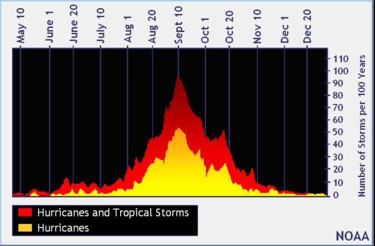
The peak of the season is Sept. 10, with the most activity happening between mid-August and mid-October, according to the Hurricane Center.
National Hurricane Center map: What are forecasters watching now?
Systems currently being monitored by the National Hurricane Center include:

Noaa
Embedded content: https://www.nhc.noaa.gov/xgtwo/two_atl_0d0.png?052051
Excessive rainfall forecast
What's next?
We will continue to update our tropical weather coverage daily. Download your local site's app to ensure you're always connected to the news. And look for our special subscription offers here.
This article originally appeared on Treasure Coast Newspapers: NHC tropics watch: No tropical cyclones expected 2-7 days

