More rain, storms, lightning to hit Dallas-Fort Worth before drying out. Here’s when
A storm system that has sat across much of the Central U.S. is moving east and a sliver of it will bring more rain and lightning to North Texas by Wednesday, according to an area forecast discussion on the National Weather Service website early Monday.
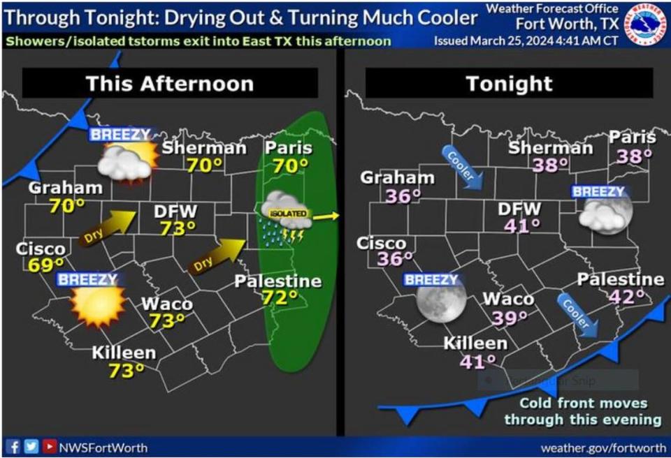
“Isolated rain showers will be possible during the day Wednesday,” but possibly unstable air brought on by rapidly dropping temperatures over the region may bring more storms and lightning by the afternoon, Fort Worth meteorologist Eric Martello wrote on the NWS website.
As the line of storms that hit Dallas-Fort Worth overnight Sunday with booming thunder and flashes of lightning weakens, moving east to Waco and Killeen, another cold front is expected to move into the region tonight bringing cooler temperatures. Only the sunshine and clearing skies Monday afternoon will keep most of the region from freezing overnight. Lows in the 30s and 40s are expected across the Metroplex early Tuesday morning.
“The brisk and occasionally gusty northwest winds continue on Tuesday despite plentiful sunshine and [solar heating],” Martello wrote. “I have leaned slightly toward cooler guidance as strong low level cold advection looks to continue through early afternoon before becoming neutral. Highs will reach the lower to mid 60s.”
⚡ More trending stories:
→ There’s no ‘better place’ to see April 8 total solar eclipse than in this tiny Texas town.
→ How a six-pack of beer, $100 got rescuers to pull pig out of thorns.
→When do tornadoes occur the most in Dallas-Fort Worth?
By Thursday, North Texas will begin to dry out up until at least Sunday with highs in the 70s, and by Friday afternoon highs in the 80s are possible for much of the area, the NWS states.
“Long-range guidance continues to hint at our next frontal system approaching North Texas in the Monday-Wednesday timeframe next week which could increase rain chances across the region,” Fort Worth meteorologist Miles Langfeld wrote on the NWS forecast discussion.

