Midweek severe storms to focus on Ohio, Michigan; Plus nighttime hail risk for Kansas City


Following a slew of severe weather incidents, including more than a dozen tornadoes over the central Plains on Tuesday, the threat of violent storms shifted eastward across the Midwest into Wednesday evening and extends into parts of the central Appalachians Wednesday night.
There were more than 100 incidents of severe weather, with tornadoes touching down from Nebraska and Kansas to Missouri and Iowa from Tuesday to Tuesday night.
 |
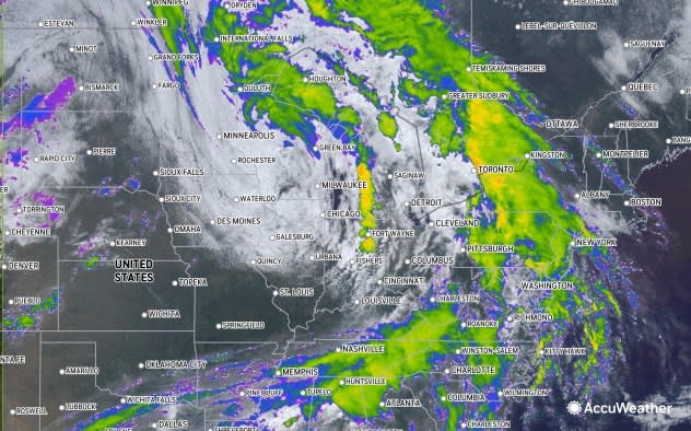
This image centered on the Midwest and Northeast was captured on Wednesday, Apr. 17, 2024. The center of the swirl of clouds marks the middle storm system. (AccuWeather Enhanced RealVue™ Satellite) |
Even though the storm system that spawned severe weather on Tuesday will be tracking into Canada, it still packed enough energy to set off damaging thunderstorms from Michigan to Tennessee, Pennsylvania, Maryland, West Virginia and Virginia into Wednesday night.
Forceful straight-line wind gusts and hail to flash flooding, and frequent lightning strikes all occurred.
Cities that were hit with severe weather on Wednesday includedDetroit; Pittsburgh and Erie, Pennsylvania; Charleston, West Virginia; and Cleveland, Youngstown and Columbus, Ohio.
Typically, the abbreviated nature of the storms would not be a concern for flash flooding. However, due to the wet state of the ground and high water levels in part of the region, it may not take as much rain to produce excess ponding or a rush of water along small streams.
Farther to the west, the atmosphere will re-energize Wednesday night over parts of the central Plains.
"In this case, thunderstorms will tend to erupt a bit higher in the atmosphere due to a layer of cool air near the ground," AccuWeather Chief On-Air Meteorologist Bernie Rayno said. "The 'elevated' storms of this nature tend to produce torrential downpours and hail."
 |
In some cases, the hailstones may range in size from a pea to a marble and can cover the ground. In more severe situations, the hailstones can grow quite large, to the size of golf balls, baseballs or larger, and can be extremely damaging.
To produce hail this size, there must be strong vertical winds, known as updrafts, in the thunderstorms to support the weight of the stones. Aircraft flying through storms of this intensity can experience violent turbulence.
 |
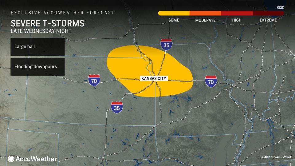
There is the potential for both forms of hail late Wednesday night to Thursday morning from northeastern Kansas and southeastern Nebraska to northwestern Missouri. In such situations, experts advise parking vehicles in garages, when possible, instead of driveways or streets, as large hail can dent the metal and break windows. Cities at risk include Topeka, Kansas; Beatrice, Nebraska; and Kansas City and St. Joseph, Missouri.
The risk of violent thunderstorms will expand and shift eastward and southward on Thursday, when powerful wind gusts are possible, in addition to large hail and flash flooding.
Want next-level safety, ad-free? Unlock advanced, hyperlocal severe weather alerts when you subscribe to Premium+ on the AccuWeather app. AccuWeather Alerts™ are prompted by our expert meteorologists who monitor and analyze dangerous weather risks 24/7 to keep you and your family safer.
