Tornado watch expires across Panhandle, some Florida counties
A strong cold front is moving through Florida today, bringing with it the potential for hail, tornadoes, strong winds and flooding rainfall.
Here's the latest on what's happening.
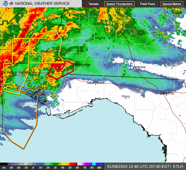
➤ Check radar to see where storms are
Hail, winds up to 50 mph possible
8:14 a.m.: A special weather statement has been issued for Perry, Madison and Mayo until 9:15 a.m.
Winds up to 50 mph and pea-sized hail are possible.
Line of strong thunderstorms moving fast with strong winds, hail
7:12 a.m.: The National Weather Service Tallahassee is tracking strong thunderstorms extending along a line from 8 miles east of Woodville to 8 miles east of Carrabelle. It's moving to the northeast at 55 mph.
Main hazards include wind gusts up to 50 mph and pea-sized hail.
Damaging winds, tornadoes, isolated hail main concerns from storms
4/3/24 7AM ET Update 📡
Continuing to watch organized storms moving across parts of SW GA & Southern FL Big Bend this morning. Damaging winds, tornadoes, isolated hail, and frequent lightning are the main concerns. There’s been a history of downed trees/powerlines. #FLwx #GAwx pic.twitter.com/LE3AiohpFq— NWS Tallahassee (@NWSTallahassee) April 3, 2024
7 a.m.: Organized storms are moving across southwest Georgia and the southern Big Bend region of Florida this morning. "Damaging winds, tornadoes, isolated hail, and frequent lightning are the main concerns. There’s been a history of downed trees/powerlines," the National Weather Service, Tallahassee said.
Hail, strong winds possible as thunderstorms approach
6:10 a.m.: A severe thunderstorm warning is in effect until 7 a.m. EDT for:
Jackson County
northern Calhoun County
northwest Gadsden County
At 6:07 a.m., a severe thunderstorm was located near Marianna, moving northeast at 60 mph.
Hazards include 60-mph wind gusts and penny-sized hail. Impacts could include damage to roofs, siding, and trees.
Severe thunderstorm warning: 60-mph wind gusts possible
6:10 a.m.: A severe thunderstorm warning has been issued until 7:30 a.m. for:
Gulf County
Wakulla County
Liberty County
Franklin County
At 607 a.m., severe thunderstorms were located along a line extending from near Stonemill Creek to 20 miles southwest of Port St. Joe, moving northeast at 45 mph.
Hazards include 60-mph wind gusts. Expect damage to roofs, siding and trees.
Tornado watch issued for 12 Florida counties
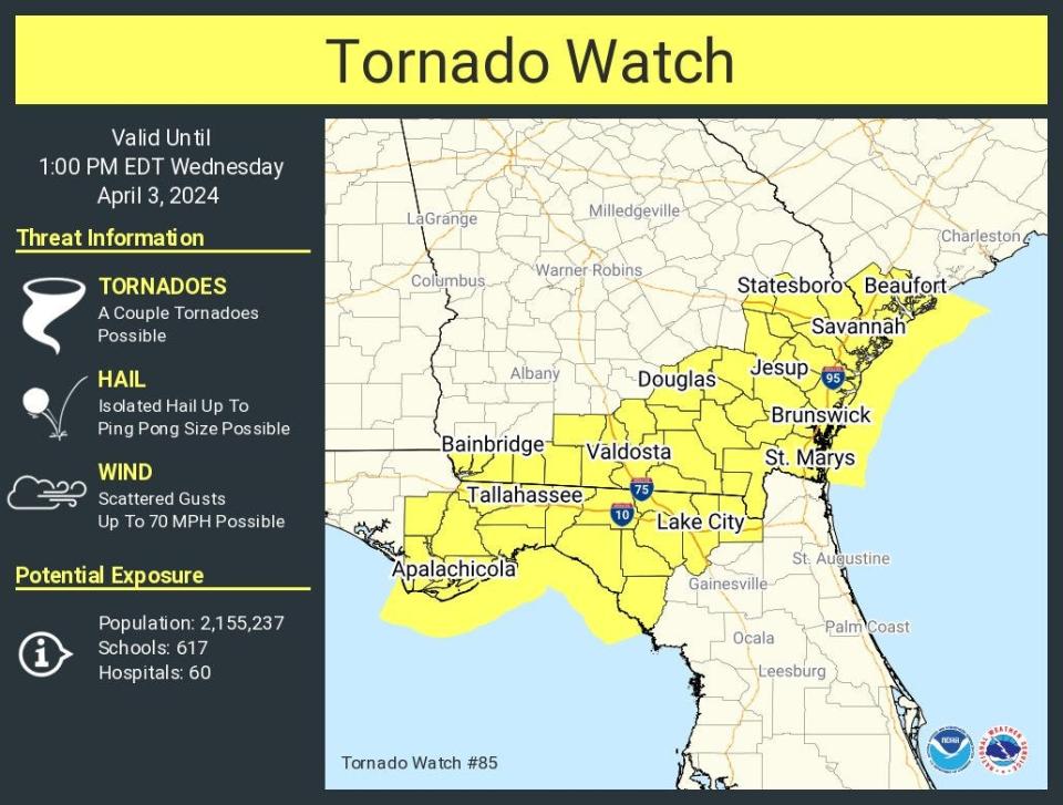
5:55 a.m.: A tornado watch has been issued for 12 counties in North Florida.
At 5:55 a.m., the National Weather Service issued a tornado watch for 12 counties in the Big Bend area until 1 p.m. EDT as strong storms move through the state.
Threat breakdown:
A couple of tornadoes are possible.
Isolated hail up to size of pingpong balls possible.
Scattered wind gusts up to 70 mph possible.
The 12 counties include:
Calhoun
Dixie
Franklin
Gadsden
Gulf
Jefferson
Lafayette
Leon
Liberty
Madison
Taylor
Wakulla
4/3/24 451AM CT 📡 🌪️
Currently watching two areas of concern. The 1st is east of Tyndall AFB where a strong wind surge is evident with multiple sites gusting well above 40 mph. The 2nd is in Baker Co, GA where strong rotation is evident & an active tornado warning. #FLwx #GAwx pic.twitter.com/JB89by7Htw— NWS Tallahassee (@NWSTallahassee) April 3, 2024
The National Weather Service Tallahassee was watching two areas of concern, including one east of Tyndall Air Force Base "where a strong wind surge is evident with multiple sites gusting above 40 mph." The second was in Bake County in Georgia where "strong rotation is evident" and a tornado warning is in effect.
Strong cold front: Cold front moving toward Florida brings risk for tornadoes, hail the size of pingpong balls
Weather alerts issued in Florida
Weather radar and forecast for Tallahassee
Follow the National Weather Service Tallahassee on X, formerly known as Twitter
This article originally appeared on Treasure Coast Newspapers: Florida tornado watch, severe weather warnings, watches

