Central Ohio avoids the worst of heavy storms, but flooding still a concern
Columbus and Central Ohio Weather
COLUMBUS, Ohio (WCMH) — Despite heavy storms and strong winds rolling through central Ohio, most areas managed to avoid heavy damage Tuesday.
However, flood waters managed to cover some major roadways throughout the region, and flooding remained a concern heading into the early morning hours.
Did you see it? After strong storms, double rainbow appears in sky over Columbus
A flood advisory was put into effect until 1:30 a.m. for Franklin, Fayette, Madison and Pickaway counties, with minor flooding in low-lying areas reported. In Licking, Pike and Fairfield counties, flood warnings were extended to later in the morning Wednesday.
In Pickaway County, several roads flooded including State Route 762 between U.S. Route 23 and SR 104 near the Scioto River bridge and SR 752 at the railroad underpass west of Ashville. The county’s emergency management services said it had to assist one stranded driver on a flooded road.
Tornado watches, warnings expire
Tornado warnings have subsided for multiple central Ohio counties Tuesday evening, but left behind tornado watches in their place.
Tornado warnings for Coshocton, Fairfield, Guernsey, Hocking, Licking, Pike and Perry counties had all expired at varying points by 9:30 p.m.; Guernsey and Muskingum counties had tornado watches expire by 10 p.m.
Severe weather is expected to continue Tuesday night in central Ohio, with strong storms in the forecast for the evening. Franklin, Delaware and Licking were among the counties under a tornado watch until 10 p.m. — those watches have expired. By late afternoon, Columbus had recorded 1.52 inches of rain, breaking the record of 1.51 inches from 1977, with more expected during the evening.
Stay with NBC4 all day for updates, including the latest forecast from Storm Team 4, live traffic conditions and the latest on closings and delays. And download the NBC4 news and weather apps to be able to receive push alert notifications.
Tornado watch area expanded
The counties under a tornado watch through 10 p.m. were expanded just before 6:30. Added were areas north, east and southeast of Columbus: Delaware, Fairfield, Hocking, Logan, Licking and Union counties. Additionally, Morgan, Perry and Athens counties have been put under a watch until 2 a.m. Wednesday.
The TORNADO WATCH has been expanded to include more counties surrounding Columbus & Franklin County.
Added:
Delaware
Fairfield
Hocking
Logan
Licking
Union
Through 10 PM tonight.@nbc4i #ohwx #tornado pic.twitter.com/spC8tcHd1U— Joe Speir (@JoeSpeirNBC4) April 2, 2024
Evacuations in Newark
Police in Newark are asking residents of two communities along the Licking River to evacuate because of rising flood waters. The two communities are Little Texas and Canterbury Trailer Park.
Earlier, city officials said they were closing the floodwall at South Second Street in Newark and, if waters continued to rise, would also do so at National Drive. Holy Trinity Lutheran Church at 592 W. Main St. was opening as a Red Cross shelter, the Licking County Health Department said.
Power companies prepare
Electric companies are preparing for potential power outages, with crews from AEP Ohio working during the day to address damage caused by the early morning rain and wind.
“Please stay away from any downed power lines, assume that any line on the ground is energized, and call 911 or call us on,” Julia Ivinskas told NBC4’s Anna Hoffman. “If you’re removing debris from your yard, make sure that you call us before you begin to do that. Even if it’s a phone line or a cable line, we can come out and assess the situation and make it safe for you to do that.”
South Side road closure
U.S. 23 going under Interstate 270 on the South Side has been closed due to flooding. Images from an OHGO camera at 3 p.m. showed the situation.
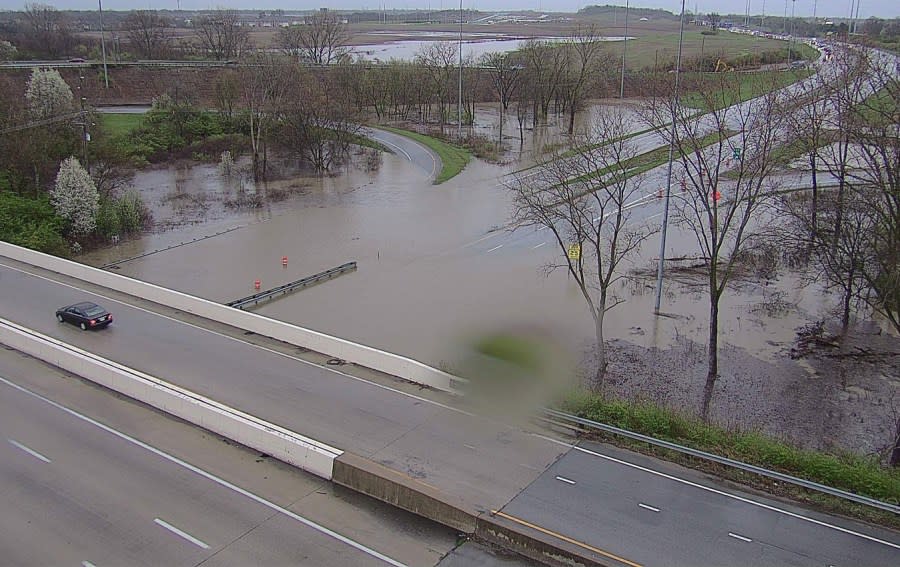
U.S. 23, also known as South High Street through the area, was closed in both directions. Ramps from I-270 West to U.S. 23 South and from I-270 East to U.S. 23 North were also closed.
Arena District postponements
The Columbus Clippers postponed their home opener at Huntington Park. First pitch had been scheduled for 6:15 p.m. Instead, the Clippers are scheduled to play at 6:15 p.m. Wednesday and then have a doubleheader starting at 4:15 p.m. Thursday.
The opponent, somewhat appropriately, is the Omaha Storm Chasers.
The Columbus Crew had been scheduled to play the UANL Tigres in a Champions Cup game next door at Lower.com Field at 7 p.m. At 5:20, CONCACAF announced the start would be delayed until 8:30.
2 p.m. forecast update
Storm Team 4 meteorologist Joe Speir posted the latest severe weather tracking information on X. “Severe weather risks still remain high today, but have shifted slightly south,” he wrote. “Still a moderate risk of tornadoes, with higher chances for longer, stronger ones. Damaging winds and large hail threats remain as well.”
Severe weather risks still remain high today, but have shifted slightly south.
Still a moderate risk of tornadoes, with higher chances for longer, stronger ones.
Damaging winds and large hail threats remain as well.
Timing is later this evening.@nbc4i #ohwx #rain #storms pic.twitter.com/zo3GgRoAQl— Joe Speir (@JoeSpeirNBC4) April 2, 2024
Olentangy dismissing early
Olentangy Local Schools, the second largest district in central Ohio after Columbus, announced early dismissal. Students will be dismissed 90 minutes early, afternoon preschool classes are canceled, and afterschool activities were all canceled.
In addition, the Columbus Zoo will close at 2 p.m., the Franklin County courthouse at 2:30 p.m., and all Columbus Metropolitan Library locations at 3:30 p.m., and Columbus State has canceled evening classes. For updates on closings and delays around central Ohio, visit the NBC4 closings page.
Franklinton floodwall closed
Floodgates are being installed along Greenlawn and Harmon avenues in Franklinton, west of Downtown. In a traffic alert, city officials advised motorists to avoid the area. Greenlawn Avenue is closed between Front Street and Harmon, and the Interstate 71 ramps to Greenlawn will be closed.
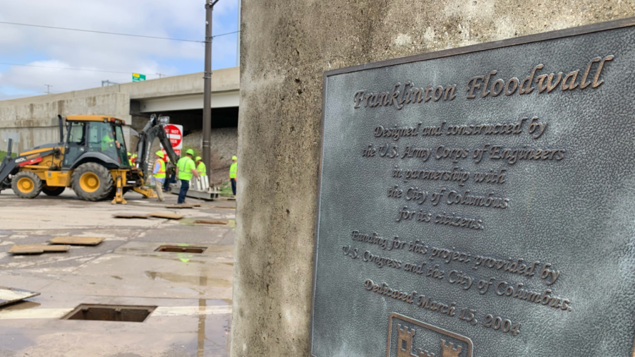
Harmon Avenue will be closed between Hart and Frank roads.
Updated traffic conditions are available at this link.
Turn around, don’t drown
FEMA issued a notice for its region that includes central Ohio. “Monitor local forecasts and prepare for the possibility of dangerous weather,” regional administrator Tom Sivak said. “Identify your safe shelter locations and remain vigilant–especially for potential power outages and dangerous road conditions caused by possible downed power lines and flooding.”
It included these tips:
Follow the direction of local and state officials and make sure to sign up for your community’s warning system. The Emergency Alert System (EAS) and National Oceanic and Atmospheric Administration (NOAA) Weather Radio also provide emergency alerts. If your community has sirens, become familiar with the warning tone.
Identify nearby, sturdy buildings close to where you live, work, study and play. Pay attention to weather reports and warnings and be ready to take shelter immediately, if necessary.
Make sure all mobile devices are fully charged in advance of the storm. Plan for batteries and other alternative power sources to meet your needs in case the power goes out, such as a portable charger or power bank. Have flashlights for every household member.
Have a communications plan in place. Ensure everyone in your household knows where to go, what to do and how to reconnect after a disaster.
Watch for fallen power lines and trees. Report them immediately.
Do not walk, swim or drive through floodwaters.
After the storm and once you are safe, check on neighbors and friends to make sure they’re okay.
For the latest news, weather, sports, and streaming video, head to NBC4 WCMH-TV.

