See photos, video of storms that damaged property, knocked out power across South MS
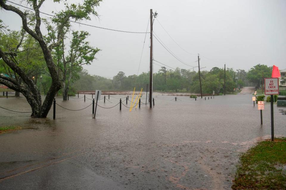
A storm system pounded South Mississippi on Wednesday with strong winds, tornado warnings and rain that flooded roadways and made travel nearly impossible in several areas of the Coast.
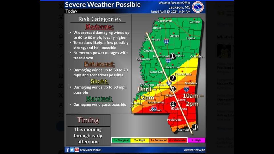
The National Weather Service issued several warnings and extended a tornado watch for Hancock, Harrison, Jackson and Pearl River counties until 4 p.m. The highest risk for tornadoes is slightly north of the coastline, but the National Weather Service warned tornadoes are possible across the Coast.
A wind advisory, coastal flood advisory and gale warning are also in effect. The wind advisory impacts the entire Coast. Forecasters issued the coastal flood advisory for Hancock and Harrison counties.
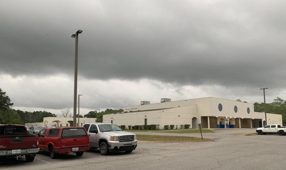
Hancock County will offer two shelters for severe weather: Leetown Shelter at 28290 Leetown Road and Necaise Shelter at 3360 Highway 603. Both opened at 10 a.m.
Check back for live updates on the latest forecasts and warnings.
2:50 p.m.
More than 10,000 customers are still without power in South Mississippi.
Mississippi Power reported that 1,163 customers across south and central Mississippi were without power Wednesday afternoon.
Singing River Electric’s outage map showed 1,379 still without power in Jackson and George counties.
Coast Electric still had 7,796 customers without power across Hancock, Harrison and Pearl River counties.
The numbers improved from Wednesday morning, when the companies reported more than 20,000 customers without power.
2:30 p.m.
A flash flood warning is in effect until 5:30 p.m. for southeastern Harrison County and southwestern Jackson County. The National Weather Service said it received reports at 11:30 a.m. of flooded roads in parts of Biloxi and expected rainfall to continue.
The NWS in Mobile also issued flash flood warnings for George and Stone counties until 3:15 p.m.
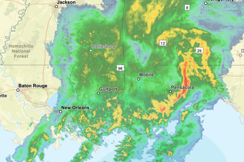
The strongest line of storms had moved east past Pensacola by 2:30 p.m. But floods as low as 6 inches can still be dangerous for people and cars, and the NWS said severe storms are still possible on the Mississippi Coast through 7 a.m. Thursday.
2 p.m.
The Mississippi Emergency Management Agency said severe weather across the state had led to at least one death and one injury.
The death was reported in Scott County, which is an hour outside of Jackson. The injury was reported in northern Mississippi in Grenada County.
MEMA said 72 homes across the state had so far reported damage but said the numbers are preliminary and will likely change. None of the numbers reported to MEMA so far have come from the six coastal counties.

1:30 p.m.
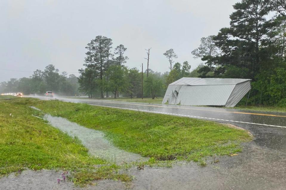
A storm that passed through Kiln and possibly produced a tornado downed power lines and trees along Highway 603, Hancock County emergency management director Brian Adam said.
Some houses in the area of Highway 603 between Kiln Deslisle Road and Firetower Road had minor damage, Adam said. No injuries have been reported.
During a tornado warning Wednesday morning the National Weather Service said a tornado had touched down in the area. Witnesses in the area believed the storm had produced a tornado, Adam said, but by Wednesday afternoon he was waiting on the NWS to confirm the tornado.
Officials will return to the area to further assess damage later Wednesday, Adam said.
A tornado appeared to hit Slidell around the same time Wednesday morning and overturned cars, damaged buildings and caused some moderate injuries, the Times-Picayune reported.
1 p.m.
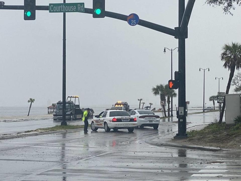
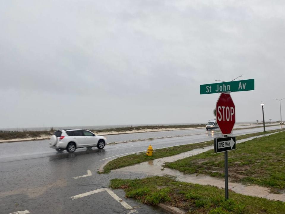
Gulfport Police shut down westbound lanes of U.S. 90 near Courthouse Road so a flooded car could be towed.
Water is also covering eastbound lanes on U.S. 90 near St. John Avenue in Harrison County.
Pass Christian Police Chief Darren Freeman said the city seemed to avoid significant damage but let city employees go home earlier to avoid driving in the stormy conditions.
12:30 p.m.
Storms are producing golf ball-sized hail in Vancleave and the Three Rivers community near Hurley, said Jackson County public safety director Earl Etheridge.
A structure caught fire in Gulfport after a lightning strike but remained under control. No injuries were reported, Gulfport Fire Chief Billy Kelley told WXXV.
12:10 p.m.
Bay St. Louis Police Chief Toby Schwartz said so far there are no reports of damage in the city.
Long Beach Police Chief Billy Seal said no damages have been reported. Seal said some roadways had flooded but none are closed yet.
12 p.m.
More than 20,000 customers in South Mississippi are without power, according to outage maps.
Coast Electric, which serves customers in Hancock, Harrison and Pearl River counties, reported 14,143 outages.
Singing River Electric reported 6,600 customers without power across Jackson and George counties.
Mississippi Power reported 1,983 customers without power on the Coast and into central Mississippi.
11:30 a.m.
Severe thunderstorms are affecting much of the Mississippi Coast and have prompted multiple tornado warnings and reports of hail and flooded roadways.
Hancock County Sheriff’s deputies and emergency management officials are on the way to Kiln, where the National Weather Service said a tornado touched down about 10:30 a.m. Hancock County Sheriff Ricky Adam said he heard reports of downed trees and power lines, and officials said more information would be available soon.
A severe thunderstorm warning is in effect for eastern Jackson County, including Pascagoula, Gautier and Moss Point, until 12 p.m. That storm could bring wind gusts up to 70 miles per hour, the NWS said.
Hail has been reported in Biloxi.
Interstate 59 in Pearl River County near Picayune is flooded and impassable, the Mississippi Highway Patrol said.
Attention travelers: Interstate 59 in Pearl River County, specifically near the 6 mile-marker close to Picayune, is currently impassable due to water covering the roadway. Please seek alternate routes and exercise caution while driving in the area. pic.twitter.com/pet8f4YONK
— MHP BILOXI (@MHPTroopK) April 10, 2024
11:05 a.m.
A tornado warning has been issued for parts of Harrison and Jackson counties, including Latimer, Wade and Woolmarket.
The warning is in effect until 11:45 a.m.
10:45 a.m.
Margaret Orr, chief meteorologist emeritus at WDSU News in New Orleans, said on Twitter that debris could be seen in satellite images of the tornado, which was north of Diamondhead by 10:45 a.m.
Definitely showing debris in air with tornado. Now North of Diamondhead. @wdsu #mswx pic.twitter.com/xZWKWDCJcU
— Margaret Orr (@MargaretOrr) April 10, 2024
10:30 a.m.
A tornado was on the ground near Kiln at 10:27 a.m., according to the National Weather Service.
The tornado-producing storm is 7 miles northwest of Diamondhead and moving northeast at 50 miles per hour, according to the NWS.
A tornado warning has been issued for northwestern Harrison County and northeastern Hancock County until 11 a.m.
It is unclear the exact location of the tornado, or what damage it may have caused. Hancock County Emergency Manager Brian Adam said at 10:35 a.m. that officials were on the way to the area to confirm the tornado and survey possible damage.
A severe thunderstorm warning is also in effect for Hancock, Harrison and western Jackson counties until 11:30 a.m. Storms on the Coast could produce winds up to 70 miles per hour, the National Weather Service said.
10:15 a.m.
A tornado warning for southwestern Harrison County and southern Hancock County is in effect until 11 a.m.
Cities in the warning include Pearlington, Bay St. Louis, Diamondhead and Gulfport.
Forecasters were tracking a severe thunderstorm four miles east of Slidell at 10:08 a.m. The storm is moving east at 65 miles per hour.
It is capable of producing a tornado and quarter-sized hail, according to the National Weather Service.
It will reach Pearlington around 10:15 a.m. Diamondhead, Shoreline Park and Kiln could see effects by 10:20 a.m.
The storm is expected to near Bay St. Louis around 10:25 a.m., Long Beach around 10:35 a.m. and Gulfport by 10:40 a.m.
10 a.m.
A tornado warning issued for Picayune and Nicholson has been extended until 10:45 a.m.
Residents in northwestern Hancock County and southwestern Pearl River County should move to basement or interior rooms on the lowest floor.
Radar has indicated rotation in a storm that was located over Slidell at 9:53 a.m. That storm is moving north at 25 miles per hour, the National Weather Service said.
Forecasters estimated the storm will near Pearl River, Louisiana about 10 a.m. and reach Picayune by 10:15 a.m.
Tornado Warning including Picayune MS, Nicholson MS and Pearl River LA until 10:45 AM CDT pic.twitter.com/tie5tyl0pC
— NWS New Orleans (@NWSNewOrleans) April 10, 2024
9:45 a.m.
A severe thunderstorm warning has been issued for Picayune and Carriere. Wind gusts could reach up to 70 miles per hour, according to the National Weather Service. The warning is in effect until 10:45 a.m.
A severe thunderstorm warning has also been issued for Poplarville until 10:15 a.m.
8:45 a.m.
A tornado warning is in effect for Picayune and Nicholson. The warning also includes Pearl River, Louisiana.
The warning extends until 9:30 a.m.
Pea-sized hail is also possible in each area.
840AM: The line of storms will be crossing I-55 around 9AM! These winds will be cross winds, so it will be more dangerous for drivers heading N/S on the interstate. Please limit driving until the storm passes and use EXTREME caution! #mswx #lawx pic.twitter.com/iyShjWTHxj
— NWS New Orleans (@NWSNewOrleans) April 10, 2024
8:30 a.m.
The weather’s worst effects are still in Louisiana, where a dangerous line of storms with winds up to 80 miles per hour moved through the Baton Rouge area about 8 a.m.
The storm system’s outer edges have begun to approach western Hancock County but no further warnings have yet been issued for the Mississippi Coast.
8AM: A VERY DANGEROUS line of storms is about to move through our NW areas, including the Baton Rouge metro area! This line has a history of widespread wind damage, including tree and structural damage. A CAT Severe Tstorm warning is out for 80mph winds or higher! Take cover now! pic.twitter.com/QWqwPphcfI
— NWS New Orleans (@NWSNewOrleans) April 10, 2024
7:30 a.m.
The line of storms hit Louisiana on Wednesday morning, prompting tornado and severe thunderstorm warnings in cities throughout the southeast part of the state. The main impacts early Wednesday were heavy rain and flash flooding, the National Weather Service said.
Forecasters estimated impacts would arrive in South Mississippi closer to 11 a.m. but cautioned storms could develop ahead of the main line.
Those storms could bring tornadoes, large hail and winds of over 60 miles per hour, the National Weather Service said.
Impacts could last through 10 p.m.
Widespread severe thunderstorms are expected today across parts of Louisiana, Mississippi, Alabama, and the Florida Panhandle. Tornadoes and widespread damaging winds are anticipated. Stay weather aware by following your NWS office and media for the latest watches and warnings. pic.twitter.com/EEoVDmQ63R
— NWS Storm Prediction Center (@NWSSPC) April 10, 2024

