The latest La Niña forecast is in. It could mean an even colder, snowier winter for Idaho
No one is ready to think about winter yet, considering the warmth of spring just arrived.
Too bad. Idaho’s chances of a snowy and cold winter are increasing as forecasters continue to build confidence in a La Niña weather pattern forming later this year.
The National Weather Service’s Climate Prediction Center issued an updated La Niña forecast May 9, upping the chances of La Niña developing this summer as El Niño continues to weaken.
According to the latest forecast, there is a 49% chance of La Niña developing between June and August, and a 69% chance of it developing between July and September.
“La Niña generally tends to follow strong El Niño events, which also provides added confidence in the model guidance favoring La Niña,” the prediction center states.
We underwent three straight years of La Niñas, from 2020 to 2023, until El Niño finally broke the cycle in late 2023 into 2024.
What is La Niña?
El Niños and their opposites, La Niñas, are naturally occurring weather phenomena that usually alternate every couple of years as a function of how the Pacific Ocean interacts with the air above it.
A La Niña occurs when the temperature of the sea is cooler than average in the eastern Pacific Ocean, resulting in less evaporation, weaker storms and less moisture in the atmosphere, according to NOAA.
That allows easterly trade winds — the permanent east-to-west winds that blow near the equator — to strengthen, allowing the Pacific Ocean’s colder waters to upwell to the surface. Those cold waters then push the jet stream farther north.
“La Niña events may last between one and three years, unlike El Niño, which usually lasts no more than a year,” National Geographic reports. “Both phenomena tend to peak during the Northern Hemisphere winter.”
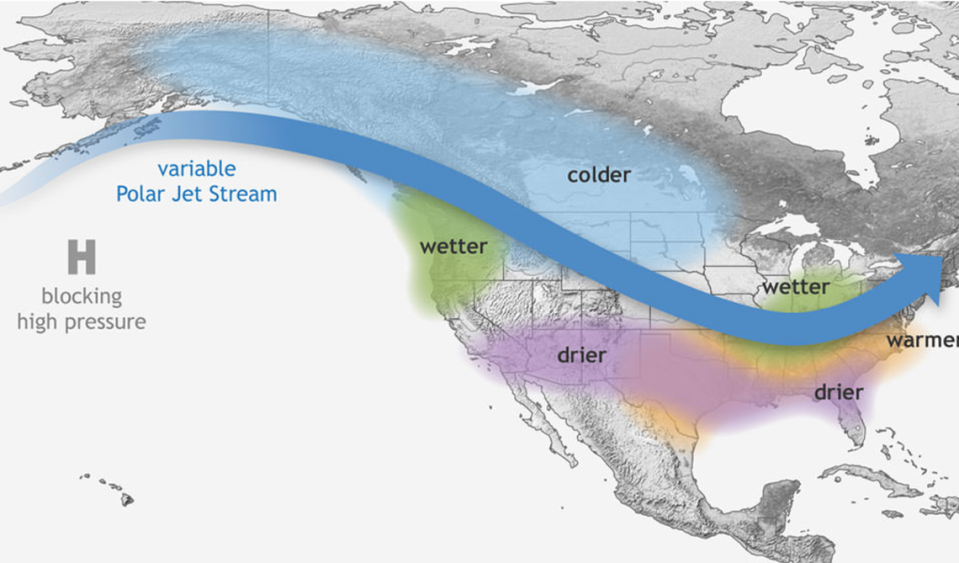
What does La Niña mean for Idaho?
One of the defining characteristics of La Niña is a weakened jet stream over the eastern Pacific Ocean.
The colder sea surface temperatures off the West Coast force the jet stream northward toward Alaska before dipping southward into mainland North America once it’s over land.
This weather pattern typically leads to drier weather in the south, according to NOAA, but wetter weather for the Pacific Northwest. Temperatures are also normally colder throughout the country’s northern half during La Niña winters.
What would that mean for Boise?
Boise experiences a typical winter — from December to February — with 14.2 inches of snow and an average temperature of 33.9 degrees, so Idahoans can expect more snow and lower temperatures than those figures.
What other impacts does La Niña have?
One of the more notable impacts of La Niña, which Idahoans fortunately don’t have to deal with, is a more active hurricane season.
La Niña decreases atmospheric stability over the Atlantic Ocean, according to NOAA, which encourages more robust hurricane growth.
Researchers at Colorado State University have predicted that 23 named storms, 11 of which will be hurricanes, will occur in this year’s Atlantic hurricane season. Both those numbers are higher than the average totals from 1991 to 2020 — on average, there are 14.4 named storms and 7.2 hurricanes per season.
Five of the 11 forecast hurricanes are predicted to reach major hurricane strength, a Category 3 or stronger hurricane capable of producing sustained winds of 111 mph or greater.

