Honea Path homeowner records possible tornado in Anderson County, NWS to assess damage
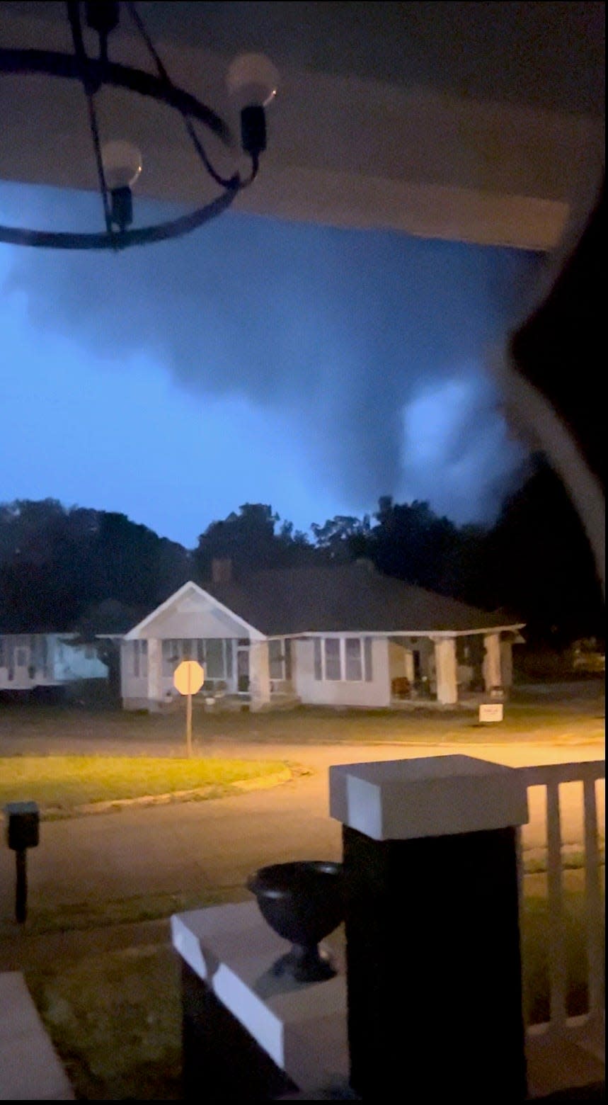
A Honea Path homeowner in Anderson County recorded what appeared to be a possible tornado on Thursday morning.
Lori Dozier captured video and photos of what appeared to be a funnel cloud in Anderson County early Thursday morning as severe storms moved through the area. She posted the video and pictures on her social media accounts.
Around 1:45 a.m. Thursday, the National Weather Service sent out a tornado warning.
"My daughter and one of my friends who lives with us were in the living room watching the storm when, all of a sudden, it started to pick up outside with high winds, rain, and extreme lightning," she said.
At 2 a.m., she started recording the storm using her cell phone, pointing it toward the neighbor's home as the children woke up the rest of the family, which included Dozier's partner, father, and son.
"We witnessed a downdraft that caused our porch lights to swing back and forth and almost tip over," Dozier said.
After recording this short clip, the family of six retreated to a small area in the house with no windows. She described it as a small rectangular hallway where three of the four bedrooms and bathrooms are located.
"We stayed in that area until almost 2:30 when the storm passed," she said. "As we sat there, we could hear thunder, which sounded like a train coming through town at a distance, and the rain, which sounded like it was coming through the roof and attic."
While sheltering, Dozier said, "we tried to keep a watch on the storm by watching the news live on Facebook and other news sources, as well as watching the windows and trying to keep the girls calm by staying calm as well."
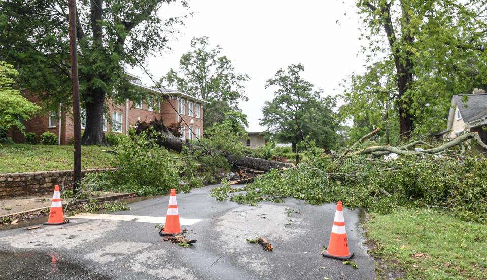
Following Wednesday night's storms, Anderson Emergency Management received reports of downed trees and power lines in the area.
Storm damage in Upstate: Power outages persist in Upstate after May 8, 9 storms: What to know about restoration
"We are doing damage assessments and are blocking off the area to keep residents safe," said Cade Treffeisen, Deputy Director of Anderson Emergency Management.
Honea Path's Mayor Christopher Burton expressed gratitude to city employees who came out Thursday morning to clear the streets. "We appreciate them so much for what they do," he said.
Once it was safe for him to venture outside, Mayor Burton said he observed numerous flooded roadways, including East Hampton Street and Brooks Street, and extensive tree damage. Alongside Fire Chief Jim Smith, he discovered several houses affected by tree damage. Luckily, there have been no reported injuries so far.
Due to the severe weather and for the safety of those affected, Anderson County School District Five decided to operate on an eLearning schedule for students on Thursday, May 9. Anderson School District Two also announced an eLearning schedule.

The following Anderson County offices were closed Thursday due to power outages:
Anderson County Courthouse Annex, 401 East River St., Anderson
Ronald P. Townsend Building, 2404 North Main St., Anderson
Treasurer and Auditor‘s offices, 4 Civic Court, Powdersville
White Street Convenience Center, 2151 White St. Ext., Anderson
Craytonville Convenience Center, 200 Wilson Rd., Belton
Special Population Recreation, 101 S. Fant St., Anderson
Senior Citizen Programs, 101 S. Fant St., Anderson
According to a Duke Energy Map of power outages in the Upstate, Anderson County was the hardest hit, with 19,000 Duke customers without power as of Thursday morning. The estimated restoration time for the county was between Thursday at 2 p.m. and Friday at 7 a.m.
Did a tornado touch down in Anderson County?
"A team will be out Friday morning around 8 conducting a storm survey," Scott Krentz of the National Weather Service said.
"Once the storm damage team from the National Weather Service arrives, they will conduct a survey together," Treffeisen said.
The survey will determine if a tornado touched down and, if it did, for how long, and access damage to the area.
According to the National Weather Service, patchy fog after 3 a.m. is expected Thursday night in Anderson County. Otherwise, it is mostly clear, with a low around 65. West southwest winds 7 to 11 mph, with gusts as high as 18 mph, are expected.
This is a developing story. Check back for updates.
Travis Rose covers Anderson County for the Independent Mail. Reach him via email at trose@gannett.com.
Greenville News reporter Nina Tran and photographer Ken Ruinard contributed to this article.
This article originally appeared on Anderson Independent Mail: NWS to assess whether tornado touched down in Anderson County

