Hollywood Park? Poverty Ridge? Here’s how 6 Sacramento neighborhoods got their names
Uniquely is a Sacramento Bee series that covers the moments, landmarks and personalities that define what makes living in the Sacramento area so special.
You might live or be in Sacramento. But where are you really?
Are you hanging out in downtown or midtown? Or are you in Land Park, Mansion Flats or Hollywood Park?
Besides tree-lined sidewalks and Victorian-style houses, Sacramento’s neighborhoods are demarcated by unique names. And some of them hint at a long history in Sacramento.
Barbara Stockman asked The Sacramento Bee: “How did the neighborhoods in Sacramento get their names? (Alkali Flat), Robla, Hollywood Park, etc. Some like Land Park are obvious but others hint at more intriguing origins.”
Stockman has been a resident of Sacramento for more than 20 years. She currently resides in the Robla neighborhood.
In addition to spending time with her family and gardening for butterflies, she told The Bee, she enjoys the diversity of history and culture in the area.
Bee Curious, a reader-driven series where reporters answer the community’s questions, dived into the origins of Sacramento’s neighborhoods.
How are neighborhoods created?
According to Sean deCourcy, preservation director with the city of Sacramento, neighborhood limits can be set for various reasons.
Boundaries are often created by property developers or they may be based on the area’s physical features, he said.
“Poverty Ridge for example is delineated by the sand dune that creates the raised land (or ridge),” deCourcy said.
Sometimes, neighborhoods may be bounded by roadways and structures.
Other times, he said, several developments may merge into one neighborhood.
How are neighborhoods named?
It all boils down to who lived in the neighborhood or who developed it.
“Neighborhood names can happen in several ways, either formally or informally,” said William Burg, president of Preservation Sacramento, a nonprofit organization that works to protect the city’s historic places.
Burg said that older neighborhoods were typically named by their residents, with monikers borrowing from the area’s geographic features or institutions.
“Many neighborhoods were established as real estate developments, given a name by the developer who established the subdivision,” he said. “The best known early subdivision of this sort was Oak Park.”
Burg added that the limits of a neighborhood and its name may change over time.
Here’s how some prominent Sacramento neighborhoods got their names:
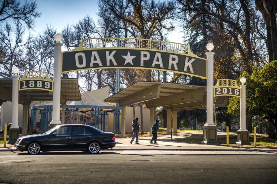
Oak Park
In 1887, real estate developer Edwin K. Alsip subdivided the 230-acre William Doyle Ranch into blocks and renamed the area Oak Park, according to the city’s historic district plan.
The new name was an ode to an eight-acre oak tree grove that grew at the center.
Prior to World War II, most Oak Park residents were of European descent, although African American and Mexican American people also lived there, local magazine Midtown Monthly reported in 2010.
After the Great Depression and World War II, middle class families and businesses left Oak Park, ushering in a new community of African American residents, according to the district plan.
Oak Park became a home to people who were previously forced out from the West End due to redevelopment projects and who were barred from living in other neighborhoods under discriminatory housing convenants.
Cultural and social organizations also moved to Oak Park, such as the Sacramento Observer, an African American-owned weekly newspaper, the Women’s Civic Improvement Club and the Sacramento Black Panther Party.
“As a result, Oak Park developed a new cultural identity as an African American neighborhood,” the city said in the district plan.
After years of growing levels of poverty and social tensions between residents and law enforcement, Oak Park has undergone rapid development in recent years.
The dramatic gentrification of Oak Park is “dizzying,” according to The Bee’s report in 2021, prompting efforts to save the community.
Boundaries: According to its historic district plan, Oak Park is “bounded on the west by 33rd and 34th streets and on the northeast by a zig-zagging line that weaves along Broadway at Second, Third, and Fourth avenues before turning northwest along Fourth Avenue and up 34th Street to Third Avenue.”
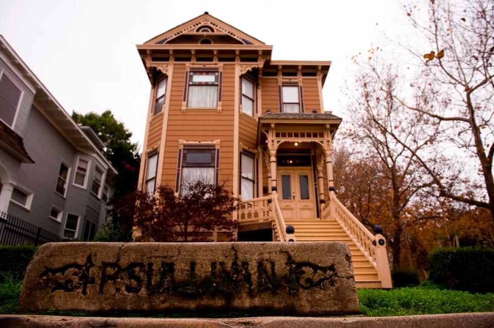
Alkali Flat
North of downtown Sacramento lies Alkali Flat — the oldest existing residential neighborhood in Sacramento, according to its historic district plan.
“Once part of a dry lakebed, it was named after the chalky, white deposits of alkali that were left on the streets after the floods that periodically affected the area,” city officials said in the plan.
The neighborhood is home to a variety of Victorian and Queen Anne-style houses; sycamore, palm and walnut trees — and previously, well-to-do and working-class residents.
Over the years, due to increasing industrialization in Alkali Flat, as well as low rent and its proximity to downtown businesses, lower income laborers began moving to the area, according to the district plan. Many of them were immigrants.
Many large homes were divided into smaller units to house multiple families at a time.
Among the new residents of Alkali Flat were Mexican Americans who fostered a strong community in the neighborhood, the district plan stated.
“The Royal Chicano Air Force, an art collective founded in 1969, based many of its activities in Alkali Flat and became one of the most dominant and influential groups in Sacramento and the national Chicano art movement,” according to the plan.
Boundaries: Alkali Flat’s boundaries are north to the Union Pacific Railroad Tracks, west to Seventh Street, south to G Street and east to 12th Street.
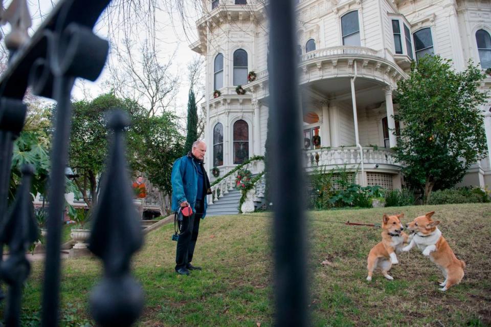
Mansion Flats
Mansion Flats is located east of Alkali Flat and hugs downtown Sacramento.
Burg said the name Mansion Flats was chosen by its neighborhood association. It references Alkali Flat and the dramatic mansions along H Street.
More specifically, the name comes from the Historic California Governors Mansion at 16th and H streets, the Alkali and Mansion Flats Neighborhood Association said on its website.
Boundaries: Mansion Flats’ boundaries go north to the Union Pacific Railroad tracks, west to 12th Street, south to J Street and east to 16th Street.
Robla
Robla is further north of downtown Sacramento, tucked between Rio Linda and Del Paso Heights.
“Robla was originally named Oak Grove in the 1890s,” Burg said.
In the early 1900s, according to the Robla School District, the area was filled with many oak trees.
The neighborhood was renamed Robla after the Spanish term roble, meaning, “a grove of oaks,” in the early 20th century, Burg said.
Boundaries: The community is bounded on the north by the city limits; on the east by Dry Creek Road to Marysville Boulevard, and then by Marysville; on the south by Interstate 80and on the west by Norwood Avenue to Claire Avenue and west to Kelton Way.

Hollywood Park
According to the Hollywood Park Neighborhood Association, the area was established in 1950.
Similar to nearby Curtis Park, Hollywood Park’s name was chosen by the developer of the area, Burg said.
A Sept. 10, 1950, article from The Sacramento Union, which is now defunct, describes Hollywood Park’s growth as “Booming Along at a Dizzy Pace.”
Extending south of the city and southeast of William Land Park to Fruitridge Road and 29th Street, Hollywood Park is “one of the fastest-growing sections in the post-World War II building boom,” Sacramento Union reporter Bill Morrow wrote at the time.
Early residents of Hollywood Park and the surrounding area included young “ex-GIs” and their families, Morrow wrote, many of whom were new to the capital city.
Boundaries: The neighborhood is bordered to the north by 22nd Avenue, to the east by 24th Street, to the south by Fruitridge Road and to the west by Freeport Boulevard.
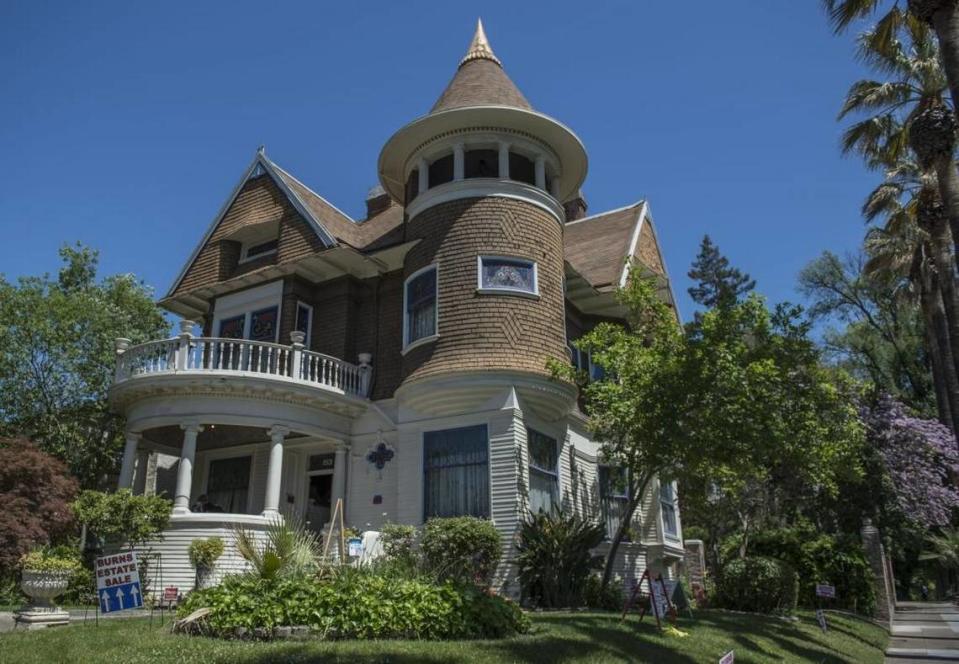
Poverty Ridge
Contrary to its name, wealth is on full display in Sacramento’s Poverty Ridge neighborhood.
“The district contains a collection of houses in a variety of architectural styles that were part of one of Sacramento’s wealthiest and most prestigious neighborhoods in the late nineteenth and early twentieth centuries,” according to the Poverty Ridge Historic District Plan.
The most extravagant and large homes can be seen on 21st and 22nd streets, the district plan stated.
Some of its former residents include author Joan Didion and Charles McClatchy, former editor of The Sacramento Bee and co-founder of McClatchy Newspapers.
“The area apparently picked up the nickname ‘Poverty Ridge’ because people who lived near the waterfront (often working people or those with limited means) supposedly ran up to the ridge when the city flooded, as it was the highest nearby ground aside from Sand Hill, site of the city cemetery,” Burg wrote in an email to The Bee.
According to the district plan, those who camped on the ridge “looked so poor” that residents dubbed the neighborhood Poverty Ridge.
In early maps of the city, Poverty Ridge was called The Ridge. Around 1860, it was also referred to as Zabriskie Ridge, Burg said.
This was in reference to Col. James Cannon Zabriskie, a well-known lawyer in the area at the time.
Around 1906, there were attempts to rename the neighborhood Sutter’s Terrace, Burg said, but the title didn’t stick.
Boundaries: Poverty Ridge’s limits are on the north by R Street, on the east between 24th and 25th streets, on the south by the Capital City Freeway and on the west between 18th and 19th streets.

