Green Bay redistricting plan would align city voting wards with new state maps
GREEN BAY - The city of Green Bay would create four new voting wards and redraw the boundaries on two existing wards under a proposed map making its way to the Green Bay City Council.
The city's Protection and Policy Committee on Monday recommended the City Council adopt a new local ward map to align the city's voting districts with new state legislative district maps Gov. Tony Evers signed into law in February. The new maps must be approved by the City Council before they go into effect.
The map is used predominantly for City Council and Green Bay School District elections to determine where city residents go to vote and whom they vote for. If adopted, the new map would go into effect for both the August partisan primary elections and the November general election, Green Bay City Clerk Celestine Jeffreys said.
The new maps create four new wards. They also redraw boundary lines for three other wards, which could see some voters change polling places beginning in August.
Here's a closer look at what to know.
Explore Wisconsin's new maps: Here's how the new Wisconsin legislative maps will impact voters in Green Bay area
Wisconsin's new legislative district maps forced Green Bay to change its maps
Evers signed new state Assembly and Senate district boundaries into law that in Green Bay split parts of Wards 11, 12, 37 and 45 into two Assembly districts. State law does not allow one ward to be divided among two Assembly districts.
The city proposed splitting four affected wards into two wards each along the Assembly District lines to comply with the new state maps. Three other ward boundaries were redrawn, too.
Voters on Green Bay's western, northern and southeastern edges will see new wards created
Here's how the new maps will divide each of the four wards in two.
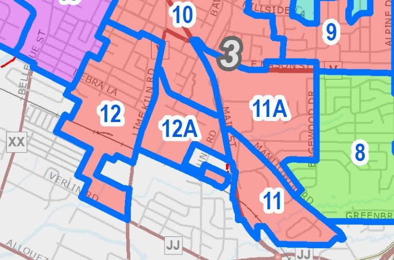
Wards 11/11A: The current Ward 11 includes the area east of Main Street, south of East Mason Street, west of Edgewood Drive and north of the Green Bay-Bellevue boundary. On the new map, the area south of Manitowoc Road would be Ward 11 and the area north of Manitowoc Road would become Ward 11A.
Wards 12/12A: The current Ward 12 includes the area south of August Street and Manitowoc Road to the Green Bay-Bellevue boundary. On the new map, the area east of Lime Kiln Road would be Ward 12A and the area west of Lime Kiln Road would remain Ward 12.
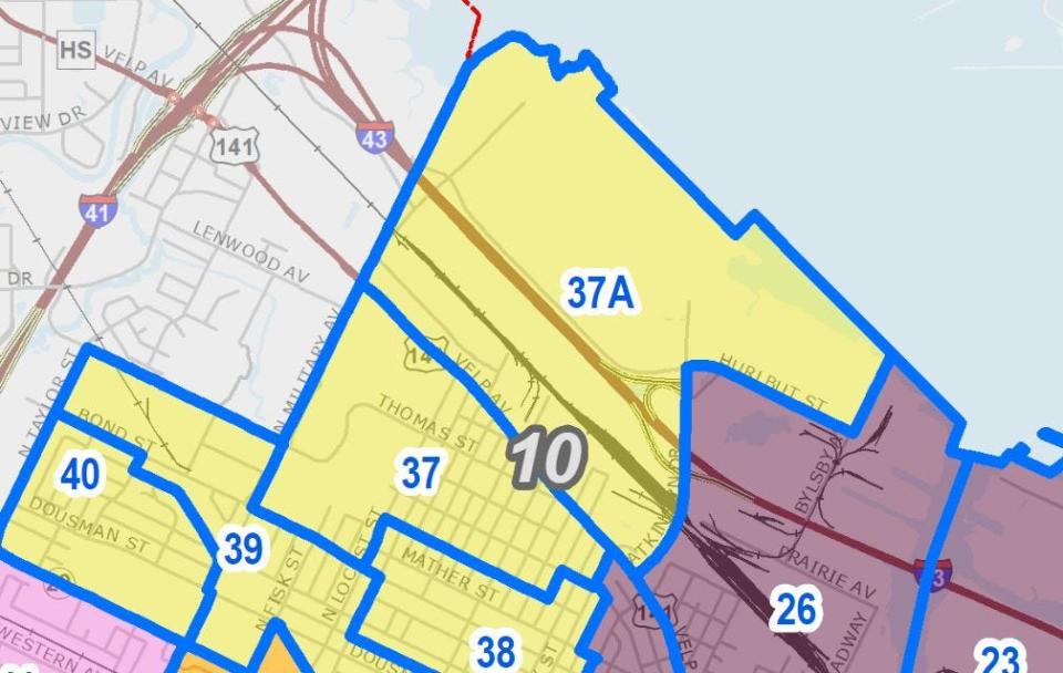
Wards 37, 37A: The current Ward 37 includes the area west of Atkinson Drive, north of Mather Street and east of North Military Avenue, along the Green Bay-Howard border. On the new map, Ward 37A is located north of Velp Avenue and Ward 37 includes the area south of Velp Avenue.
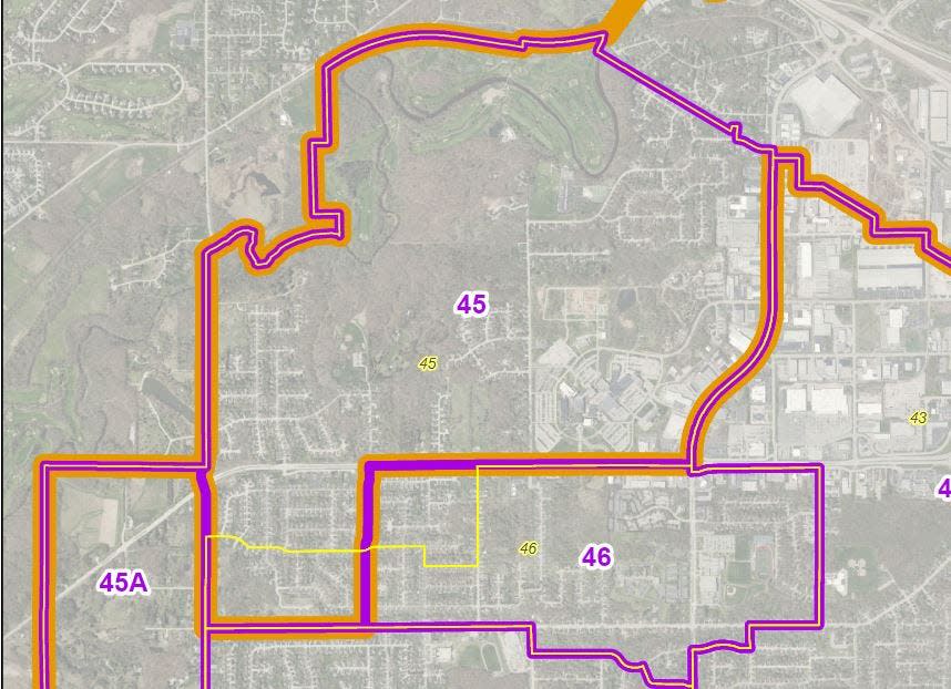
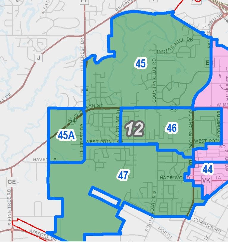
Wards 45, 45A: The current Ward 45 includes the area west of Packerland Drive, south of the Oneida Golf Club, to the Green Bay-Hobart boundary on the west and Haven Place, Sandia Drive and West Mason Street to the south. On the new map, the majority of the district would remain in Ward 45. Ward 45A would include the small area from Hillcrest Drive west to the Green Bay-Hobart boundary.
Redrawn districts means voters in 4 wards may go to new polling places on Green Bay's west side
The Assembly maps also impacted Wards 26 and 27, and Wards 45 and 46, but city staff was able to redraw those ward boundaries in such a way that the districts swapped voters and aligned with the Assembly maps.
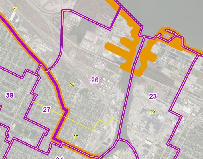
Wards 26 and 27 currently are divided by Bond Street and both span the area from the Fox River west to Atkinson Drive. The new map would instead use Velp Avenue/Mather Street to divide the wards, with Ward 27 south and west of Velp/Mather and Ward 26 east and north of Velp.
Wards 45 and 46 currently include sections of the city west and southwest of the Northeast Wisconsin Technical College campus. The new map would move a portion of the neighborhood east of Lacount Road from Ward 45 into Ward 46 while some voters west of Lacount Road would move from Ward 46 into Ward 45.
The redrawn boundaries will mean affected voters will cast ballots at new polling places.
Where will these new wards vote in Green Bay?
Here are the polling places for the proposed new and redrawn wards:
Ward 11, 11A: Central Assembly Church, 831 Schoen St.
Ward 12, 12A: Central Assembly Church, 831 Schoen St.
Ward 26: Salvation Army, 626 Union Court
Ward 27: First Presbyterian Church, 200 S. Ashland Ave.
Ward 37, 37A: St. Paul's Church, 341 Wilson Ave.
Ward 45, 45A: The Cornerstone Room of the Green Bay Botanical Garden, 2600 Larsen Road
Ward 46: Church of Christ, 2683 West Point Road
Will affected residents vote for a different Green Bay City Council member?
None of the redrawn or newly created wards will see residents shift from one City Council district to another.
Wards 11, 11A, 12 and 12A are in City Council District 3, represented by William Morgan.
Wards 26 and 27 are both part of City Council District 7, represented by Alyssa Proffitt.
Wards 37 and 37A are in City Council District 10, represented by Ben Delie.
Wards 45, 45A and 46 are in City Council District 12, represented by Kathy Hinkfuss.
Affected residents will get a postcard in the mail. And you can always check MyVote Wisconsin
Jeffreys said the city plans to send residents in the affected wards a postcard notifying them of the change and where their polling location is.
"For voters, some things will have changed and we will notice everybody impacted so they’re aware," Jeffreys said.
As always, any resident can visit My Vote Wisconsin to register to vote, find out where their polling place is and find out what's on their ballot. Jeffreys said MyVote Wisconsin may take a couple of weeks to update with after the City Council acts on the new maps.
Contact Jeff Bollier at (920) 431-8387 or jbollier@gannett.com. Follow him on Twitter at @JeffBollier.
This article originally appeared on Green Bay Press-Gazette: Green Bay voting ward changes would align city with new state maps

