Frosty night tonight, nice start to week ahead!
Alerts Issued for Our Region
FROST ADVISORY for Wyoming and McDowell counties tonight from 1 AM to 9 AM. With temperatures dropping into the low 30s, frost could harm sensitive outdoor vegetation. Bring them inside or cover them up, as they could be damaged or killed if left uncovered.
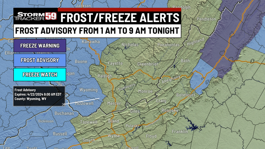
Tonight features a slow clearing trend of cloud cover, with the biggest headline being our risk for frost. Temperatures area-wide will drip down into the low 30s, with sheltered spots and the mountains dropping into the 20s. This will create a substantial risk for frost, which is why a frost advisory has been issued for our western counties tonight. Many counties in our region are still not quite in the growing season yet, hence why more frost advisories are not issued. Regardless, if you have planted anything yet, it would be a good idea to either bring those plants inside or cover them up! By dawn, skies will be mostly clear.

Monday will start on a very cold note, so the kiddos will want the jackets with temperatures in the low 30s and upper 20s heading off to school in the morning. We will see a big rebound in temperature though despite a northwest breeze, with high temperatures rebounding to the mid and upper 50s. That’s still cool compared to normal for this time of year, but at least we’ll have plenty of sunshine for our Earth Day!

Tuesday sees our wind shift from coming from the northwest to coming out of the southwest, and that will warm us up nicely to around normal for this time of year, with high temperatures in the mid to upper 60s. Skies will begin to increase in cloud cover toward dinnertime as high pressure moves away from the region and a cold front approaches from the west. With warm temperatures, breezy conditions and low humidity expected, there will likely be an increased fire risk on Tuesday. Thankfully rain showers will arrives Tuesday night as our cold front moves in.

Wednesday begins on a wet note, with scattered showers around, as our cold front crosses. However, as the day goes by, we’ll see conditions become drier, as our cold front exits and high pressure begins to scoot in. High temperatures will be in cooler in the low 60s.
How Cold is Too Cold? Spring Planting Guide
Thursday looks great! After another cold and potentially frosty start with low temperatures in the mid 30s, we will see plenty of sunshine with high pressure in control. Temperatures will jump nearly 30 degrees during the day, with high temperatures in the low to mid 60s.

Friday will be dry for most of the day, with mostly sunny skies to start. We’ll see a southwest breeze kick in as our next storm system approaches. A warm front will push through on Friday afternoon, which will give us the chance for a couple of isolated showers late as high temperatures push toward 70 degrees.

Saturday brings a weak cold front through the region, but that won’t be the end of our shower chances, as an unsettled pattern sets in. Despite the front crossing, it’s still a mild day on tap, with high temperatures in the low 70s and our steadiest rains during the morning hours. Rain will become more scattered as we head into the afternoon.

Sunday provides the risk for a few isolated to widely scattered showers but we should see plenty of dry time. It’s a warm day on tap for the two Virginias, as high temperatures spurt into the mid 70s.
Tick season is here: Here’s how to protect yourself and your pets
Looking ahead, we’ve got a bit more of an unsettled pattern taking shape. Monday features the risk for a few isolated showers but it’s very warm! We’ll see highs near 80 on Monday. We’ve reached 80 degrees once so far in April – perhaps we can do it again! Showers look likely with a low pressure system nearby Tuesday with highs in the low 70s. We look pretty dry Wednesday with a shower or two possible late in the day with another system nearby as highs jump into the mid 70s.

Help us with our growing community of weather photos with #weathertogether. Head to our website and search for the ‘Weather together’ tab and upload your photos of weather going on around our region.

We are in spring forest fire season in West Virginia – this means don’t burn between 7 AM and 5 PM through May 31st. Low humidity values during the daytime, along with breezier and warmer conditions will at times increase the fire threat, hence the burn ban during most of the daytime. Follow all regulations or be faced with potential consequences, such as fines! In Virginia, the spring fire season continues through April 30th – don’t burn before 4 PM.

TONIGHT
Clearing skies. Frosty! Lows in the low 30s.
MONDAY
Mostly sunny. Highs in the mid to upper 50s.
TUESDAY
Partly cloudy. Isolated showers late. Highs in the mid to upper 60s.
WEDNESDAY
Showers likely, especially early. Highs in the low 60s.
THURSDAY
Mostly sunny. Highs in the low 60s. Frost possible in the morning.
FRIDAY
Mostly sunny. Increasing clouds late. Highs near 70.
SATURDAY
Showers likely, especially early. Highs near 70.
SUNDAY
Isolated showers. Highs in the mid 70s.
MONDAY
Partly sunny. Highs near 80.
TUESDAY
Showers likely. Highs in the 70s.
WEDNESDAY
Partly sunny. Highs in the 70s.
For the latest news, weather, sports, and streaming video, head to WVNS.

