First, a blizzard warning in Southern California. Now thundersnow?
A series of low-pressure systems packing cold air straight from Canada has brought low-elevation snow and a rare blizzard warning for Southern California’s mountains. Now, as if to add an exclamation point to the freakiness of this week’s weather, there has been thundersnow in the Southland — and more could be on the way.
A weather spotter near the Devore neighborhood of San Bernardino reported hearing thunder Thursday as a particularly cold and unstable part of a series of storms moved through the San Bernardino Mountains, according to Alex Tardy, a meteorologist with the National Weather Service in San Diego.
Thunderstorms are less common in the winter, but sometimes lightning and thunder can occur in a snowstorm. This dramatic and fairly rare phenomenon is known as thundersnow, and it usually accompanies intense storms. Wintertime thunder can be harder to hear than in a summer storm because of the muffling effect of the snow, but it is the result of the same mechanics inside the storm cloud.
Thundersnow was reported with heavy snow that blanketed Buffalo, N.Y., in November, for example. Residents reported lightning flashes in the sky as snow piled up on the ground. If it’s uncommon in Buffalo, which is known for heavy lake-effect snow, it is much more unusual in Southern California, where any snow is a rarity.
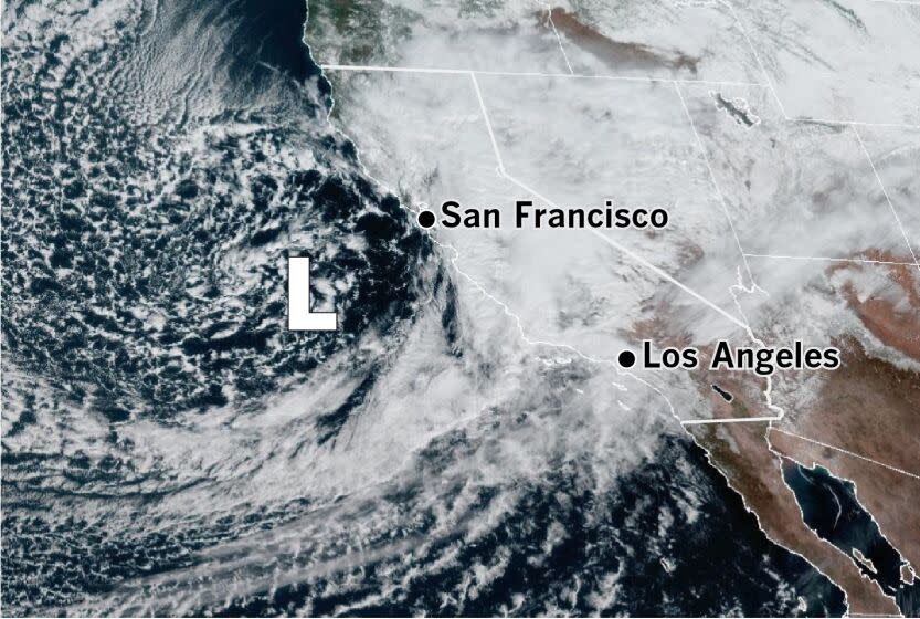
More thundersnow may be possible Saturday. A late-morning satellite image Friday shows the main event: a powerful low-pressure system dropping down the California coast and tapping into a weak atmospheric river of moisture from the Pacific Ocean. Heavy snow and gusty winds with this storm will create dangerous conditions in the mountains through the weekend, the National Weather Service said.
A snowstorm intensifies into the blizzard category when winds reach 35 mph with snow and blowing snow, and visibility declines to less than a quarter-mile for three hours or more. A severe blizzard means winds exceeding 45 mph with low visibility and temperatures of 10 degrees Fahrenheit or lower. When winds blow around snow that has already fallen, that is called a “ground blizzard.”
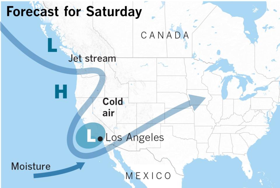
And there will already be snow to blow around when the main low center arrives.
The satellite image also shows the popcorn-like clouds over the ocean, indicative of an intense, cold storm, justifying the first blizzard warning issued by the weather service for Southern California since 1989.
Early Saturday, the low-pressure system will be centered west of the Channel Islands. As it moves east across the coast and inland, conditions will make thundersnow likely in the mountains of Southern California, National Weather Service meteorologist Eric Boldt said.
“With the atmospheric river as well, sometimes we get a few strikes, since there is so much moisture depth but little instability,” Tardy said. The core of the cold upper-level low-pressure system moving in Saturday morning would be the time to watch for thundersnow, he said.
This story originally appeared in Los Angeles Times.

