Evening shower and storm tonight, drying out for Saturday
The Latest Northeast Wisconsin Forecast from Storm Team 5…
A warm front lifted through today and brought a diminishing line of showers and storms earlier today. Cloudy but dry conditions have worked its way in for now, but a cold front is approaching. This front will bring a line of showers and thunderstorms this evening into the early overnight hours and eventually clear our around midnight, but could be even earlier.
There is a Marginal Level 1 out of 5 Risk for severe weather for Green Bay and points south. This category means that one or two storms will become severe bringing damaging wind gusts and hail up to 1in. There is a low end chance of a spin up tornado, but the best chance for that will be in far southern Wisconsin.
After midnight, clouds will really begin to clear out and temperatures fall into the 40s and 50s for overnight lows.
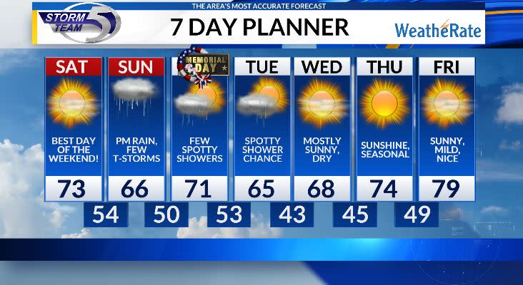
Tomorrow, soak in the sunshine and warmth as it will be the pick day of the weekend. High pressure works in and brings wall to wall sunshine for the morning hours before a few clouds work in during the late afternoon. Highs tomorrow will sit in the low to mid 70s and will be a touch breezy also. Cloud coverage will then increase overnight and lows into the 50s.
Sunday starts off cloudy and dry, but a low pressure system bring showers and storms into the picture during the afternoon. Highs into the mid 60s, a cooler then average day.
This area of low pressure will keep a few showers around early on Memorial Day morning, but then I’m thinking we dry out for a period of time before a weak disturbance brings showers later in the afternoon. Highs into the low 70s on Monday. More showers Tuesday before a ridge builds in and keeps us sunny and dry the rest of the week.
Copyright 2024 Nexstar Media, Inc. All rights reserved. This material may not be published, broadcast, rewritten, or redistributed.

