East Coast on guard as Franklin is on track to become a hurricane
Visit The Weather Network's hurricane hub to keep up with the latest on tropical developments in Canada and around the world
The Canadian Hurricane Centre (CHC) issued its first statement on Tropical Storm Franklin on Friday, advising folks across the Atlantic provinces to keep a watchful eye on the storm’s developments over the next couple of days.
Franklin is on an uncertain path right now, and small changes in the environment around the storm will decide whether it affects the East Coast or heads out to sea.
DON’T MISS: The best way to prepare for a hurricane is well ahead of a potential disaster
Franklin down now, but likely a hurricane by Sunday
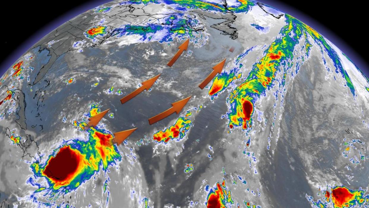
Tropical Storm Franklin struggled a bit on Friday in the face of adverse conditions, packing maximum winds of about 80 km/h on Friday evening. But the environment ahead of the storm will improve enough that forecasters expect it to steadily grow into a hurricane this weekend.

Strong westerly winds displaced most of Franklin’s thunderstorms away from the centre of the system. Thunderstorms need to sit over or near the centre of circulation in order for a storm to thrive.
Forecasters expect this wind shear to let up this weekend, allowing the storm to rebound and grow to hurricane strength by Sunday.
The @ECCC_CHC continues to monitor Tropical Storm #Franklin today. We have issued a preliminary information statement and will be updating this through the weekend. https://t.co/x0aAjJ3uRP pic.twitter.com/AXG4pi5Q2A
The ECCC Canadian Hurricane Centre on Twitter: "The @ECCC_CHC continues to monitor Tropical Storm #Franklin today. We have issued a preliminary information statement and will be updating this through the weekend. https://t.co/x0aAjJ3uRP pic.twitter.com/AXG4pi5Q2A / Twitter" continues to monitor Tropical Storm ECCC Canadian Hurricane Centre on Twitter: "The @ECCC_CHC continues to monitor Tropical Storm #Franklin today. We have issued a preliminary information statement and will be updating this through the weekend. https://t.co/x0aAjJ3uRP pic.twitter.com/AXG4pi5Q2A / Twitter" today. We have issued a preliminary information statement and will be updating this through the weekend. ECCC Canadian Hurricane Centre on Twitter: "The @ECCC_CHC continues to monitor Tropical Storm #Franklin today. We have issued a preliminary information statement and will be updating this through the weekend. https://t.co/x0aAjJ3uRP pic.twitter.com/AXG4pi5Q2A / Twitter" ECCC Canadian Hurricane Centre on Twitter: "The @ECCC_CHC continues to monitor Tropical Storm #Franklin today. We have issued a preliminary information statement and will be updating this through the weekend. https://t.co/x0aAjJ3uRP pic.twitter.com/AXG4pi5Q2A / Twitter"
— ECCC Canadian Hurricane Centre (@ECCC_CHC) ECCC Canadian Hurricane Centre on Twitter: "The @ECCC_CHC continues to monitor Tropical Storm #Franklin today. We have issued a preliminary information statement and will be updating this through the weekend. https://t.co/x0aAjJ3uRP pic.twitter.com/AXG4pi5Q2A / Twitter"
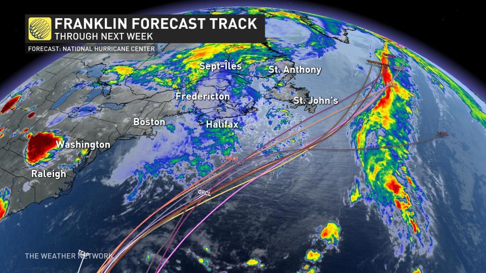
“Confidence continues to grow that the centre of the storm will pass south of Nova Scotia on Wednesday but will come close to Newfoundland and Labrador late Wednesday or Thursday,” the CHC said in its statement on Friday afternoon.
“Interests in Atlantic Canada should continue to monitor the evolution of this storm over the weekend and into next week.”
WATCH: Atlantic Canada braces for a potential hurricane landfall next week
Atlantic Canada should remain on guard as Franklin moves north
A complex environment over North America and the Atlantic Ocean will guide Franklin on its eventual path. We’re still more than five days away from any potential impacts on the East Coast, which is at the far end of forecasters’ ability to confidently predict a storm’s track.
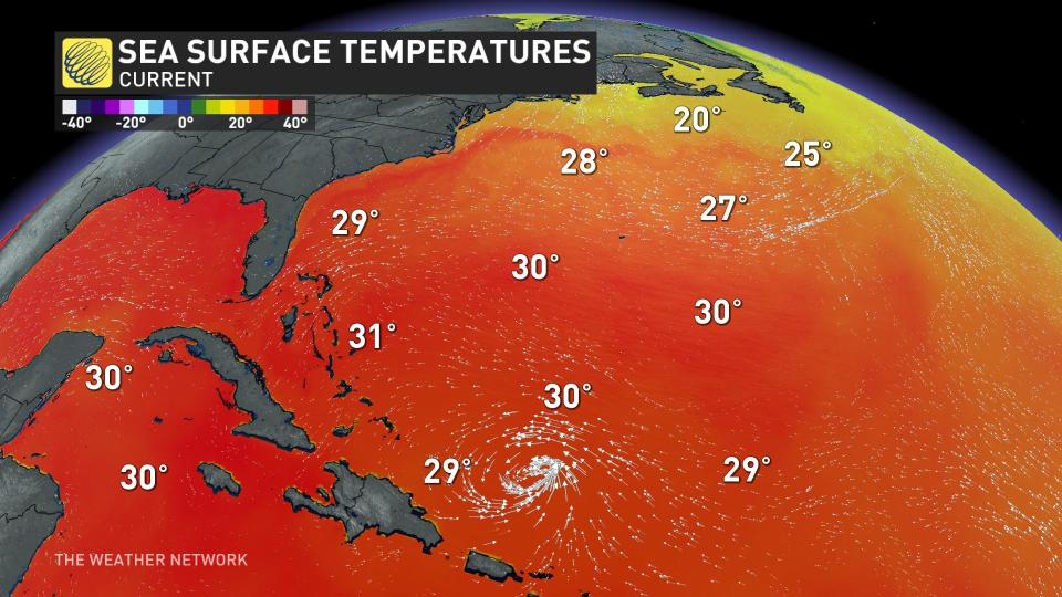
RELATED: How hot water fuels the world’s most powerful hurricanes
Lots of factors play into a tropical system’s trajectory, and it only takes small changes in the storm or the environment around it to have a large impact on the system’s intensity and track.
Ridges of high pressure over both the U.S. and the middle of the Atlantic will act like guard rails that prevent the storm from simply turning left into the Carolinas or east out to sea. Meanwhile, a trough heading toward the East Coast could grab hold of Franklin and pull it closer to shore.
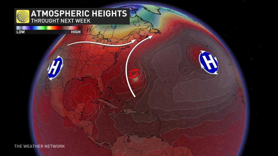
Current forecasts call for the storm to slowly pick up speed as it curves between the U.S. and Bermuda, heading in the general direction toward Atlantic Canada by the middle of next week.
Subtle changes in the strength and position of those upper-level ridges and troughs will determine how far west Franklin is able to trek before it starts curving out to sea.
Continue checking back in the days ahead as forecasters see clearer details on Franklin's path and its potential impacts on the Atlantic provinces.
Prepare now for potential hazards next week
We’re rapidly approaching the peak of the Atlantic hurricane season. Regardless of Franklin’s path, residents across Atlantic Canada should be prepared to respond to an approaching storm throughout the season.
STAY SAFE: What you need in your hurricane preparedness kit
Ensure you have enough food, water, basic supplies, and batteries to last several days without electricity. Actual flashlights are a must-have in any storm prep kit—the flashlight on your smartphone will drain your device’s battery in a hurry.
Have a plan in place if you live in an area prone to flooding, and keep several routes in mind in case nearby roads are flooded due to heavy rain or high surf.
Take a moment to look around your home and secure any object that could blow around in gusty winds. Calmer weather is the perfect time to trim any trees or tree limbs that loom large over your property. Trees falling into homes is the leading cause of wind-related injury during any storm.
Stay with The Weather Network for the latest updates throughout hurricane season.

