Colorado’s 14er peaks may have new elevations, according to federal estimates
DENVER (KDVR) — Colorado has many mountains that exceed 14,000 feet in elevation, and many of the beloved 14ers just got new measurement estimates.
“These peaks are all slated to become a bit ‘shorter’ in a few years, with the implementation of the new national vertical datum,” a release from the National Geodetic Survey said.
A team of NGS researchers published a study in the Journal of Geodesy with updated estimations for each of the state’s 14,000-foot mountains, along with uncertainties on the new values.
The changes are due to the upcoming use of new national geopotential data as well as a re-analysis of the original heights based on classical geodetic surveying techniques.
Here’s when seasonal mountain road closures will be lifted in Colorado
Each 14er is still above the 14,000-foot threshold, however, the rankings regarding how high each summit is have done some “shuffling,” according to the NGS. For example, Huron Peak is now the lowest 14er, with a newly estimated elevation of 14,004.1 feet.
The NGS said the elevations that are currently published in the North American Vertical Datum of 1988 (NAVD 88) were found to be about a meter too high.
“To investigate and correct this, the team developed a novel technique to redetermine these heights from the historical triangulation data that was measured in the 1950s,” the release said.
Researchers expected statewide elevations to change to 60 centimeters lower, but the NGS said the researchers “discovered that the summits were actually appearing to decrease by almost another meter.”
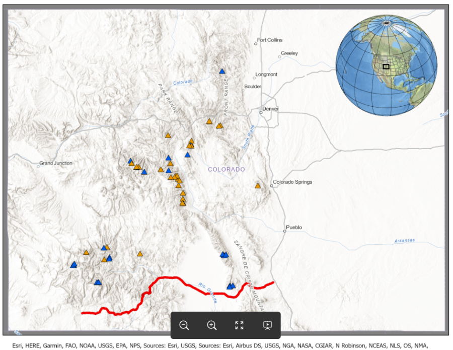
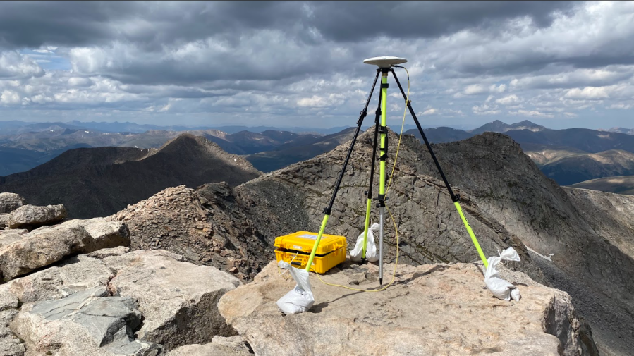
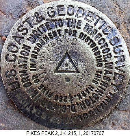
Distribution of 14ers in Colorado. Peaks with triangulated heights in orange, without triangulated heights in blue, and GSVS17 stations shown in red. From Ahlgren et al. (2024) (National Geodetic Survey) Static GNSS Survey of mountain summit station at the top of Mt. Blue Sky. (Photo: Brian Shaw, National Geodetic Survey) Triangulation station disk on Pikes Peak. (Photo: National Geodetic Survey) Historical photograph of triangulation survey on Uncompahgre Peak from Schott (1900) US Coast and Geodetic Survey Special Publication 4. (Courtesy: National Geodetic Survey)

Researchers reevaluated the historical triangulation data from the 1950s that was originally used to estimate mountain elevations, and the triangulation-based zenith angles were found to be too high by about 100 centimeters, according to the NGS.
The results of the study highlight the differences in the various geoid models, which was particularly important for the geodesy community, the NGS said.
Download the FOX31 App: Breaking news alerts & Pinpoint Weather
Going forward, the NGS said the National Spatial Reference System will be modernized and new datums will replace all three North American Datum of 1983, including NAVD 88.
Here are the newly estimated 14er elevations, according to the NGS:
Name | Estimated Total Uncertainty (1s): [m] | Elevation (NAPGD2022* Orthometric Height): [feet] |
Mt. Elbert | ±0.064 | 14437.6 |
Mt. Massive | ±0.061 | 14423.9 |
Mt. Harvard | ±0.062 | 14421.7 |
Blanca Peak | ±0.080 | 14348.5 |
La Plata Peak | ±0.068 | 14343.0 |
Uncompahgre Peak | ±0.065 | 14315.8 |
Crestone Peak | ±0.121 | 14296.8 |
Mt. Lincoln | ±0.060 | 14290.6 |
Grays Peak | ±0.061 | 14275.5 |
Castle Peak | ±0.065 | 14272.3 |
Torreys Peak | ±0.061 | 14270.1 |
Quandary Peak | ±0.058 | 14269.9 |
Mt. Antero | ±0.067 | 14269.0 |
Mt. Blue Sky | ±0.068 | 14266.1 |
Longs Peak | ±0.073 | 14255.9 |
Mt. Wilson | ±0.066 | 14254.1 |
Mt. Cameron | ±0.061 | 14245.9 |
Mt. Shavano | ±0.064 | 14228.3 |
Mt. Princeton | ±0.077 | 14200.1 |
Mt. Belford | ±0.065 | 14199.6 |
Mt. Yale | ±0.063 | 14197.0 |
Crestone Needle | ±0.125 | 14194.8 |
Mt. Bross | ±0.060 | 14177.9 |
El Diente Peak | ±0.064 | 14173.2 |
Kit Carson Peak | ±0.113 | 14165.2 |
Maroon Peak | ±0.063 | 14161.5 |
Tabeguache Peak | ±0.067 | 14157.0 |
Mt. Oxford | ±0.062 | 14156.3 |
Mt. Sneffels | ±0.070 | 14153.3 |
Mt. Democrat | ±0.061 | 14152.3 |
Capitol Peak | ±0.060 | 14136.3 |
Pikes Peak | ±0.067 | 14107.0 |
Snowmass Mountain | ±0.060 | 14101.7 |
Windom Peak | ±0.070 | 14087.0 |
Mt. Eolus | ±0.071 | 14085.0 |
Challenger Point | ±0.113 | 14084.6 |
Mt. Columbia | ±0.064 | 14072.6 |
Missouri Mountain | ±0.069 | 14069.2 |
Humboldt Peak | ±0.118 | 14066.6 |
Mt. Bierstadt | ±0.072 | 14064.5 |
Sunlight Peak | ±0.071 | 14059.0 |
Handies Peak | ±0.069 | 14055.9 |
Ellingwood Point | ±0.081 | 14054.9 |
Culebra Peak | ±0.068 | 14053.2 |
Mt. Lindsey | ±0.083 | 14053.2 |
Mt. Sherman | ±0.064 | 14040.4 |
North Eolus | ±0.071 | 14039.8 |
Little Bear Peak | ±0.089 | 14039.5 |
Redcloud Peak | ±0.097 | 14036.0 |
Conundrum Peak | ±0.065 | 14034.7 |
Pyramid Peak | ±0.067 | 14027.1 |
Wilson Peak | ±0.075 | 14020.4 |
San Luis Peak | ±0.071 | 14020.2 |
North Maroon Peak | ±0.063 | 14019.9 |
Wetterhorn Peak | ±0.062 | 14018.9 |
Mt. of the Holy Cross | ±0.060 | 14005.2 |
Sunshine Peak | ±0.075 | 14004.5 |
Huron Peak | ±0.063 | 14004.1 |
The NGS noted that these measurements are preliminary as a final version of NAPGD2022 has yet to be officially defined.
For the latest news, weather, sports, and streaming video, head to FOX31 Denver.
