Chance of severe thunderstorms in Asheville, WNC overnight; April snow coming Thursday?
ASHEVILLE — The National Weather Service issued a hazardous weather outlook for Asheville and the rest of the Western North Carolina mountains, as a severe thunderstorm system moves across Tennessee and into the area overnight April 2.
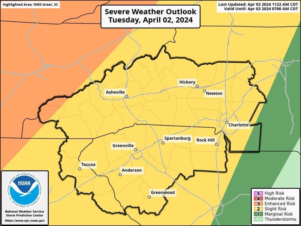
Meteorologist Christiaan Patterson with NWS told the Citizen Times that there's a "pretty good chance" of thunderstorms with a "slight risk" of severe storms in the Asheville area.
"There's a very small sliver of enhanced risk for severe weather over the western mountains, but that's not including Asheville," Patterson said. "Asheville is pretty much in a slight risk, but we have all hazardous conditions possible from isolated tornadoes to some hail."
More: Hot Pi Day? March heat a temperature record for Asheville area weather?
Patterson said storms are expected to start in Asheville around 1 to 2 a.m. April 3, and should be through the area by 5 to 6 a.m.
The hazardous weather outlook from NWS says that isolated damaging wind gusts are expected across WNC, upstate South Carolina and northeast Geogia, with the strongest storms being capable of "producing isolated brief tornadoes."
However, Patterson said isolated tornadoes will likely be more southern near the border of South Carolina and are less likely in the mountains.
"Isolated large hail and localized flash flooding cannot be ruled out," the NWS weather outlook said. "While the threat for severe weather will be slightly higher across the mountains, severe thunderstorms are possible anywhere across the area tonight."
More: Answer Man: Earth just broke climate heat record in February, what about Asheville?
WNC might see an April snow
Though Asheville saw temperatures as high as 81 degrees April 2 before the storm system rolled through the area, the front will cool off temperatures, with highs in the 50s "until at least Saturday," Patterson said.
An inch or two of snow atop Mount Mitchell and other high elevations around WNC is possible April 4, though she said it's hard to tell for sure a couple days out.
"(Asheville) might get a flake. It's not likely to accumulate in Asheville through Wednesday night," Patterson said. "Thursday looks like any kind of flurries will be constricted to the higher elevations."
Overnight temperatures are expected to drop near freezing starting April 4, with a drop below freezing overnight Saturday, April 6, according to NWS.
"Then temperatures will start to recover and warm on Sunday," Patterson said. That's just in time for the total solar eclipse on April 8.
More: What kind of weather will Asheville, Hendersonville experience during the 2024 eclipse?
Ryley Ober is the Public Safety Reporter for Asheville Citizen Times, part of the USA Today Network. Email her at rober@gannett.com and follow her on Twitter @ryleyober
This article originally appeared on Asheville Citizen Times: Asheville under slight risk for severe storms; snow possible April 4

