Central PA has observed an unusually warm, wet spring. Has El Niño played a role?
Showers and even an occasional thunderstorm are back in the forecast for the State College area Wednesday, continuing what has already been a wet and gloomy start to the spring season.
Wednesday’s showers and storms are expected to produce around 0.2 inches of rain, and heavier amounts are possible if strong thunderstorms strike. Alex DaSilva, a long-range meteorologist at AccuWeather in State College, says the unusually wet spring is not unique to Centre County.
“A lot of Pennsylvania is in the same boat,” DaSilva said Tuesday. “Almost the entire state is above normal since the start of the year when it comes to precipitation.”
State College is approaching record levels of measured precipitation through mid-April, and more rain is in the forecast for this week. Here’s what you need to know about central Pennsylvania’s wet start to the spring.
Is State College on track for above-average rainfall this spring?
A quick glance at the latest figures from the National Weather Service shows State College is well above normal levels of precipitation at this point in the year.
Through April 16, State College has received 17.14 inches of precipitation since 2024 began, according to NWS archive data. That figure falls well above an average year, which would have produced about 10.58 inches of precipitation through this point in the spring. This spring’s totals were aided by heavy storms in early April that poured nearly 4 inches of rain on the State College area and contributed to flooding and school closures throughout Centre County.
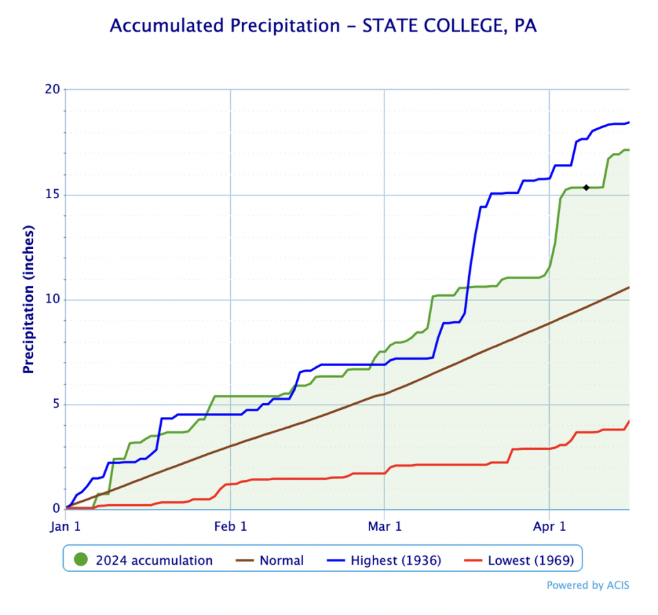
Continued rainfall over the next few weeks could push State College closer to the all-time record, set in 1936 with 18.45 inches of precipitation produced between Jan. 1 and April 16. No year on record was more dry in that period than 1969, which saw just 4.22 inches of precipitation fall in that months-long span.
The Centre County area’s above-average precipitation rates are particularly noteworthy since central Pennsylvania observed such a mild winter, especially concerning snowfall.
Just about 22 inches of snow fell in State College since last October, marking roughly half of a typical year’s winter season snowfall (43.6 inches). All that snow accounts for only a few inches of liquid precipitation, as the NWS generally estimates 13 inches of snow equals about 1 inch of rain.
Despite the below-average snowfall in Centre County, precipitation levels in the area are 14% above normal from October to mid-April, DaSilva says. Plenty of rain has helped make up for the mild winter, and not all of it is bad news.
“One good thing it did was help us with any kind of drought we had,” DaSilva said. “No part of Pennsylvania is currently experiencing any drought, and that’s no surprise given how much rain we’ve received. I think that’s going to be good news heading into the spring and summer.”
DaSilva expects things to dry out in May as temperatures rise and rain becomes less frequent. Near- or below-average precipitation is expected in June, July and August, though temperatures should be warmer than usual.
“So, a hot, sort of dry-ish summer might be in the cards,” DaSilva said. “It’s good that we got all of this rain, because if we were in a drought now, it could worsen during the upcoming seasons.”
How has El Niño affected central Pennsylvania’s rainy spring?
El Niño, a notable climate pattern that can significantly influence weather and climate, has undoubtedly played a role in Pennsylvania’s unusual winter and spring, Da Silva says.
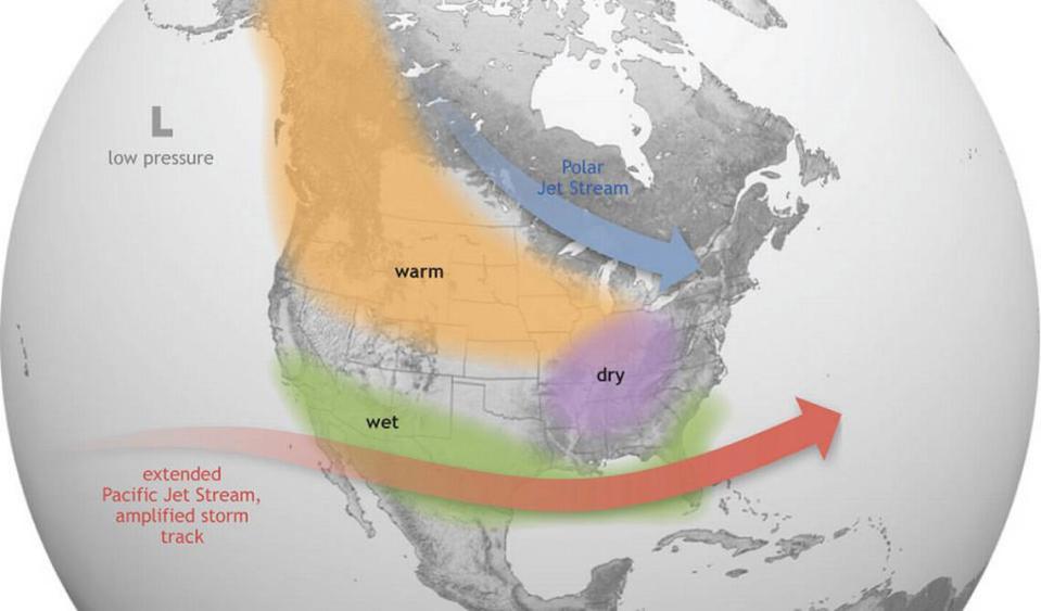
During an El Niño pattern, important trade winds weaken and build up concentrations of warmer water along the equator in the eastern Pacific Ocean. Warmer water can work to alter jet streams and climate systems that help regulate temperatures and precipitation and aid the distribution of nutrient-rich water throughout the U.S. and other parts of the world.
Mild winters are typical when El Niño is in the picture. DaSilva estimates the State College area observed temperatures that were, on average, roughly 4.5 degrees Fahrenheit above historical normals between October and mid-April.
“We’ve been seeing storm system after storm system, which isn’t terribly unusual entering an El Niño spring,” DaSilva said. “We’ve seen a lot of precipitation, but it hasn’t been cold enough for snow. We’ve seen a lot of wind storms thanks to many low-pressure systems cutting up through the Appalachians, and that’s brought us a lot of rain, too. If we’d seen those systems just off the coast and bringing in some cooler air, maybe we would’ve gotten a lot of snow this winter.”
El Niño’s influence is on the way out, DaSilva says, and its effects are beginning to approach neutral levels. El Niño’s sister system, La Niña, is expected to take hold eventually, likely bringing warmer and wetter weather to the northeastern U.S.
“We’re likely going to enter a La Niña pattern, and that should bring major ramifications for the tropical season,” DaSilva said, referencing La Niña’s tendency to produce a more active and severe hurricane season.
The National Oceanic and Atmospheric Administration’s Climate Prediction Center estimates roughly a 60% chance of seeing a La Niña pattern develop between June and August. Atmospheric abnormalities in the Pacific Ocean produced by El Niño are already weakening, the agency says.

