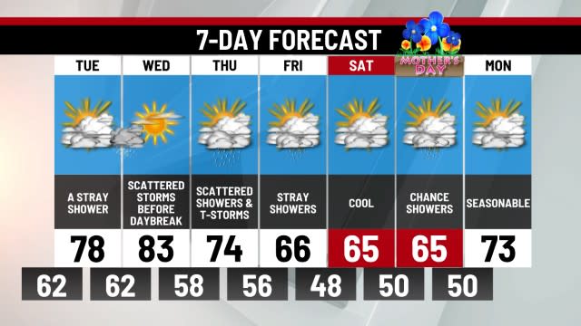
Cool, dry air returns to end the week
EVENING: A stray shower, breezy and cooler. Temps dropping into the 50s.
TONIGHT: Clearing skies, breezy and cool. Patchy valley frost. Low 40.
THURSDAY: Mostly sunny and cooler. High 58.
Wrapping up a Wednesday that brought a few showers and sunshine throughout the day. This resulted from a front that is dropping south, allowing another round of cool and dry air into the Midstate to end the week.
This dry air will lead to patchy frost potential again on Thursday and Friday mornings. Some clouds and a breeze could linger tonight, which may help prevent frost from being a major concern. Friday morning definitely looks like the best chance for frosty spots. Tomorrow will bring partly cloudy skies and a cool afternoon with highs just shy of 60°. Friday looks nice with lots of sunshine and highs in the lower 60s. Pleasant but cool will be the theme to end the week.
The weekend will slowly transition to a warm pattern that begins next week. This transition could lead to a passing shower or two, otherwise, a quiet weekend is on tap before we get into the 80s for several days next week.
-Meteorologist Eric Finkenbinder
For the latest news, weather, sports, and streaming video, head to ABC27.

