Blown Over: Strong winds Saturday fade before ramping up again Sunday night
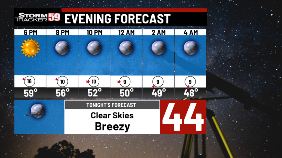
Tonight winds relax a good bit from the 40-50mph gusts we’ve seen today to a more manageable 10-15mph with 20-25mph wind gusts. A clear and mild night for April as lows drop back from the 60s at sunset into the 40s for overnight lows.
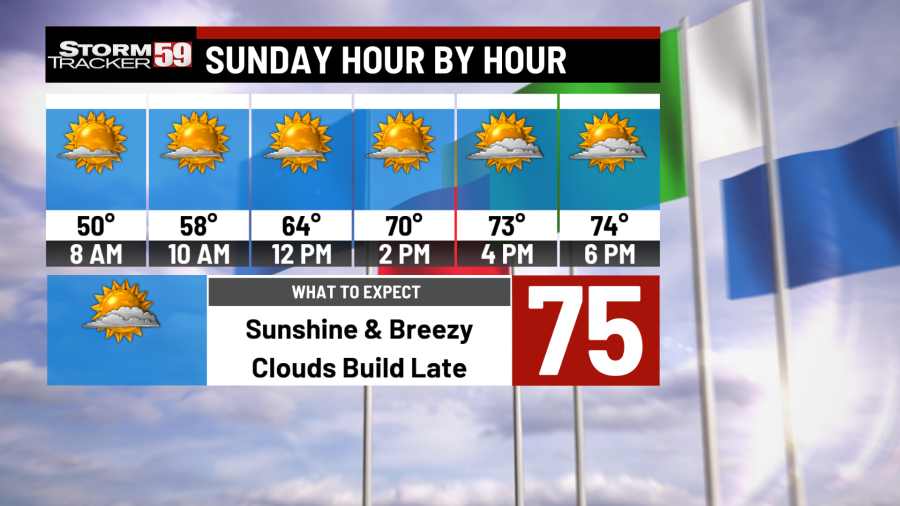
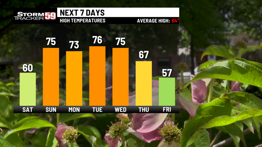
Sunday morning will be cool but pleasant with temps in the 40s and rising steadily after sunrise. We’ll pushing into the mid and upper 70s by the afternoon just in time for the winds to return. 15-20mph winds with gusts pushing 25-30mph at times, especially later in the evening. Clouds will return by the evening hours with a few showers trying to roll down from a system towards Ohio & Pennsylvania.
The weakening system doesn’t look to have the muster to make it too far south but those north of Beckley and Lewisburg could run into a rumble of thunder towards nighttime. Rain will last through the overnight with lows in the mid to upper 50s for a humid night.
Monday showers and mostly cloudy skies continue making for an umbrella morning for those heading back to work and school. Temps are mild in the mid and upper 50s and despite clouds, we still manage to warm back into the 70s with westerly winds 10-15mph. Showers fade by late evening as skies begin to clear for Tuesday morning.

Tuesday sunshine warms us up from the 50s into the upper 70s by the afternoon. If clouds hold off, we’ll have our first 80 degree day for a few towns towards the southwest of Beckley. However, with heat and humidity, pop up showers and even a rumble of thunder for the later afternoon is looking likely. The added instability by an approaching warm front for Wednesday could trigger a few showers, especially late evening Tuesday. Widespread showers become more likely overnight into Wednesday with lows in the mid to upper 50s.
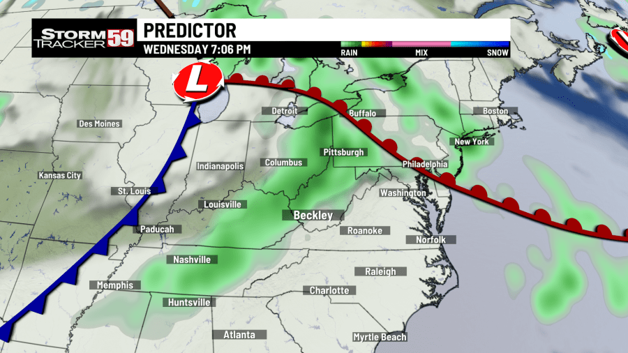
Wednesday another system moves into the region with clouds and scattered showers. Temps are mild and we’re humid so afternoon highs won’t have any trouble pushing into the low to mid 70s. By the afternoon, showers turn to thunderstorms that roam here and there across the region. If you don’t already have our app, it can be a great tool to alert you when lightning is in your area. T-storms fade into the night with steady showers lasting through Thursday morning with lows in the 40s.
Thursday starts soggy and cool in the 40s but we’ll start to see breaks between the clouds Thursday afternoon. A breezy day with clearing skies keeps temps in the mid to upper 60s as cooler air starts to push in for the end of the week.
Friday another system slides in for the morning with a few showers and thunderstorms. Scattered in nature, it’ll be a good day for the interactive radar we offer on our weather tab. These showers will scoot our rather quickly with just a few isolated chances Friday night. Highs take a hit dropping into the upper 50s.
In your extended forecast the spring storm season if fully underway making this a great time to prepare for Mother Natures worst. Especially when the weather is quiet. We’ll see a few breaks between storms where sunshine rules the forecast but temps are unseasonably cool heading into the end of April. Gardeners take note of overnight lows as we dip into frost and freeze territory next weekend.

TONIGHT
Clear, calmer winds. Lows in the low to mid 40s.
SUNDAY
Sunny & breezy. WARM! Showers late. Highs in the mid 70s.
MONDAY
Rainy start, some dry time PM. Highs in the mid 70s.
TUESDAY
Sunny & Warm. Clouds again late. Highs in the low 80s.
WEDNESDAY
Showers and T-storms. Highs in the 70s.
THURSDAY
AM Showers, PM Clearing. Highs in the 70s.
FRIDAY
Showers, breezy, & cooler. Highs in the 60s.
SATURDAY
Clearing and cooler. Highs in the upper 50s.
SUNDAY
Sunshine, near average. Highs in the upper 50s
MONDAY
Sunny and warmer. Highs in the 60s.
TUESDAY
Showers early then T-storms. Highs in the 60s.
For the latest news, weather, sports, and streaming video, head to WVNS.

