Area schools delayed as strong morning storms produce a tornado in southwest Johnson County
Driving rain, 70 mph winds and hail greeted Johnson County residents early Friday morning, less than three days after a separate, destructive storm wreaked havoc in the western part of the state.
A tornado warning, issued shortly after 6:30 a.m., sounded alarms and prompted schools to delay classes due to a string of storms that had the potential to produce tornadoes.
The Iowa City Community School District, Iowa City Regina and Cleark Creek Amana each delayed school two hours Friday morning, according to KCRG.
The same was true for schools in the Cedar Rapids Community School District, which announced on its website that students would not be released early as is typical on Fridays.
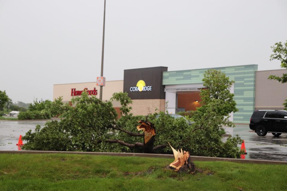
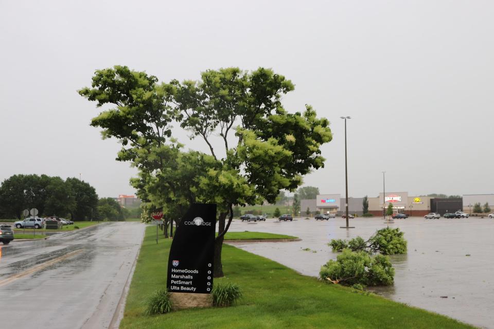
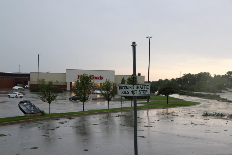
As of 9 a.m., portions of Highway 1 in Iowa City were closed near the intersection with Governor Street. Traffic was being rerouted down Kimball Road.
3:15 p.m: National Weather Service confirms EF1 tornado
An EF1 tornado touched down and rolled between the communities of Wellman and Frytown on Friday morning, an analysis by the National Weather Service confirmed.
The tornado damaged trees and outbuildings, with windspeeds reaching approximately 100 miles per hour.
More preliminary NWS survey results: An NWS survey team has determined an EF-1 tornado occurred this morning from Wellman, IA (Washington County) to the Frytown area (Johnson County) damaging trees and outbuildings. Max winds were around 100 mph. #iawx
— NWS Quad Cities (@NWSQuadCities) May 24, 2024
2 p.m.: Tornado devastates rural Johnson County farm
Rick Brenneman woke up around 5 a.m. Friday, as he always does, joking that he “works from home” as a farmer in southwest Johnson County.
He noticed windy conditions as he started his day near the intersection of 540th Street SW and Angle Road SW, just outside the unincorporated community of Frytown.
“All of the sudden, boom,” Brenneman said. “There were trees falling in my backyard, branches falling, whatever. It was chaos. Crazy.”
He hunkered down in his home for about five minutes as the storm − and a Johnson County Emergency Management confirmed tornado − passed through.
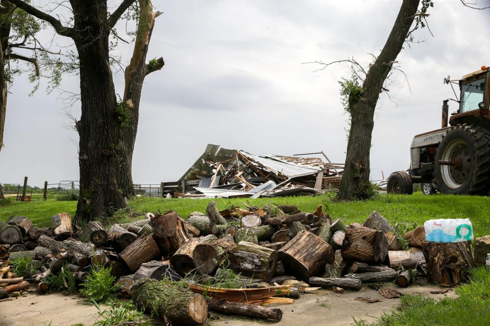
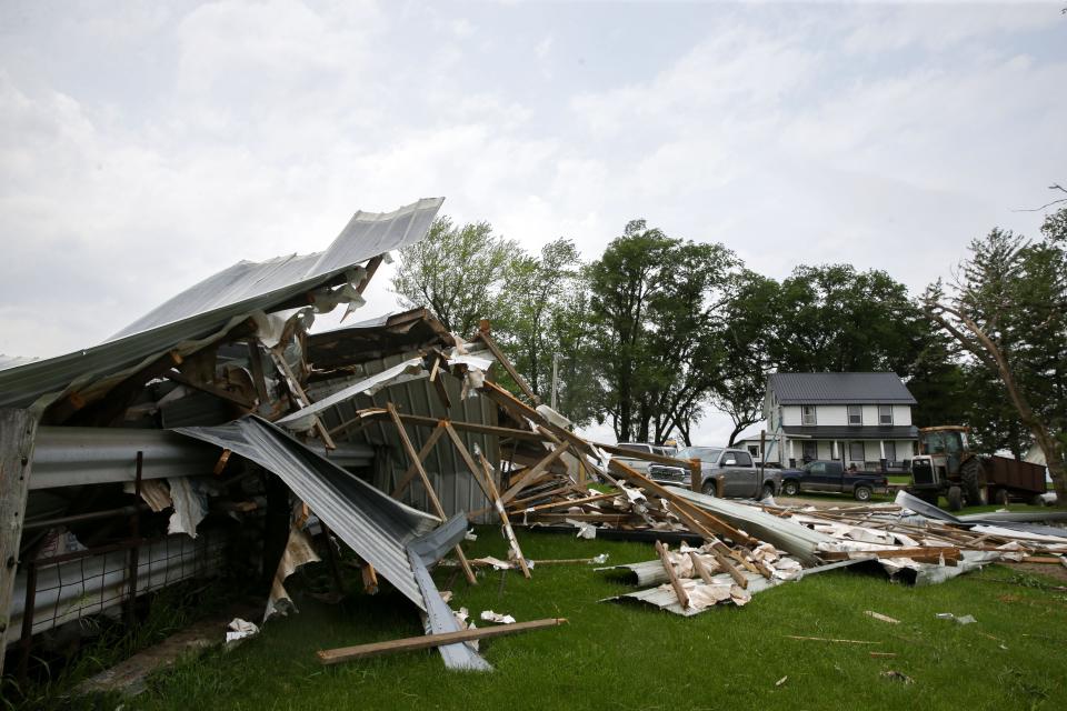
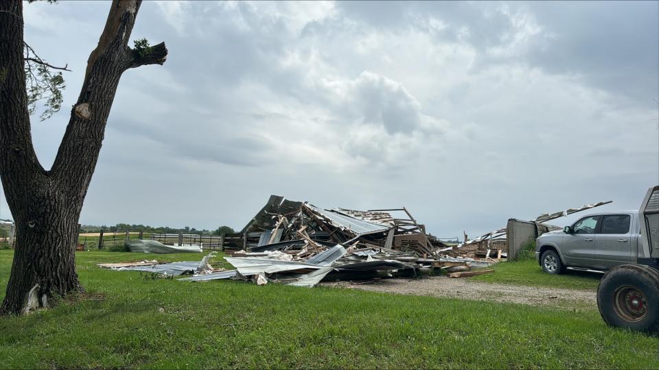
“Then, I looked out the front door,” Brenneman said. “The barn was gone.”
A severe thunderstorm storm had formed and blown overhead so fast, and coupled with the sound of falling branches all around, Brenneman didn't even hear the barn come down.
He ran over in search of the cows and calf that were inside, thinking they had surely been crushed.
“I was digging my way through the rubble," Brenneman said. "And there they were looking at me,”
1:30 p.m.: One injury, no residents displaced in Johnson County
A semi-truck was turned on its side in the strong winds, the lone injury related to Friday morning’s strong storm system, Johnson County Emergency Management Director Dave Wilson said.
A homeowner in Coralville had a tree drop onto his roof. Lightning struck a building in Iowa City, causing a small fire. The netting at Brown Deer Golf Course sustained minor damage.
Wilson estimated that about 50 properties were damaged to some degree — the majority of which were in the southern part of Johnson County. The damage was not significant enough to require temporary shelter, he said.
By 9 a.m. Friday, Johnson County signed a disaster declaration and requested inclusion in the state’s Individual Disaster Assistance Grant Program, which helps homeowners recover from up to $5,000 in storm damage.
Fortunately, Wilson said many of the families he spoke with have property insurance and “appear to be doing pretty well” in the aftermath.
“I would say we’re very fortunate,” Wilson said.
12:30 p.m.: Local officials believe EF0 or EF1 tornado touched down near Frytown
Johnson County Emergency Management Director Dave Wilson told the Press-Citizen that an EF0 or EF1 tornado touched down and damaged property in the southwestern part of the county early Friday morning.
"We're fairly comfortable that it is (EF0 or EF1 rated) based on a combination of some straight-line winds in excess of 70 miles an hour and some people that visually spotted tornadoes," Wilson said.
He said witnesses spotted the tornado on the ground near 540th Street in southern Johnson County near the town of Amish and the unincorporated community of Frytown.
Rick Brenneman’s barn near 540th Street and Angle Road was demolished by the tornado. He initially thought his two cows and a calf perished, but later found them alive after digging through the rubble.
Wilson also said officials are investigating a similar-sized tornado that may have touched down near Lone Tree, southeast of Iowa City.
The National Weather Service in the Quad Cities will assess the damage later this afternoon before providing a preliminary rating.
11:45 a.m.: More severe storms could impact commute home
Radar indicates that more severe storms may arrive in Johnson County around 4 p.m. Friday afternoon. Thunderstorms are expected to hit the heart of Iowa City around 4:45 p.m. en route from the southwest.
11:30 a.m.: Tornado touched down in Frytown
KCRG TV in Cedar Rapids reported that a tornado touched down in the small, unincorporated Johnson County community of Frytown early Friday morning.
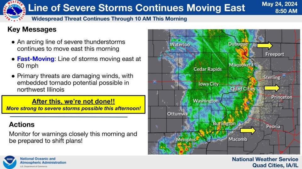
9 a.m.: NWS says storms aren't yet done
The National Weather Service said rain will continue in Johnson County through at least 10 a.m. The storm system is moving at a 60 mph clip into western Illinois, with the potential to produce more tornadoes.
The National Weather Service also indicated that more severe storms are possible in the afternoon.
⛈️An arcing line of severe storms continues to move east at 60 mph this AM. The primary threats are damaging winds, with embedded tornadoes possible in northwest IL. After this line moves out, WE ARE NOT DONE! More strong to severe storms are possible this afternoon. #IAwx #ILwx pic.twitter.com/oEpKD1H8mS
— NWS Quad Cities (@NWSQuadCities) May 24, 2024
8:15 a.m. : Tornadoes spotted near Wellman, Lone Tree
The Quad Cities National Weather Service reports that a tornado touched down near Wellman in Washington County.
The tornado was first spotted on the ground around 6:30 a.m. east of Kinross. The twister was estimated around 50 yards wide and traveled roughly a mile and a half.
Local law enforcement also reported touch down at 6:35 a.m. in Wellman.
The National Weather Service also reported structural damage to businesses and homes and Lone Tree in Johnson County around 6:45 a.m. Initial reports, according to the NWS, suggest a tornado could have touched down.
More: Discover the 6 best burger restaurants in Iowa City, from gourmet to classic delights
Severe Thunderstorm Warning continues for Iowa City IA, Muscatine IA and Coralville IA until 7:45 AM CDT. This storm will contain wind gusts to 70 MPH! pic.twitter.com/eDZBAuih5k
— NWS Quad Cities (@NWSQuadCities) May 24, 2024
7:30 a.m.: Storms produce strong winds, loads of rain and thunder
Weather spotters observed tornadic activity near Kalona and Wellman, the NWS said. The alert also warned of possible hail.
Cities near the Des Moines metro experienced widespread power outages from overnight storms. As of 7:45 a.m. Friday, almost 25,000 MidAmerican Energy customers in central Iowa were without power.
The National Weather Service said they tracked a 70 mph wind guest around 7 a.m. near Highway 6 and 1st Avenue in Coralville that knocked down several tree branches.
A little more than 425 MidAmerican Energy customers and more than 1,000 Alliant Energy customers reported outages in Iowa City.
More: Protesters allege civil rights violations following no-trespass order at Iowa City encampment
We've received reports of power lines downed during this morning's storms. Be careful when you head out this morning! #iawx pic.twitter.com/43N6n2nU0W
— NWS Des Moines (@NWSDesMoines) May 24, 2024
During severe weather, what's the difference between a watch and a warning?
A watch means that conditions are favorable for severe weather, but not immediately occurring, according to the National Weather Service, which is responsible for issuing weather alerts.
A watch is used when the risk of hazardous weather has increased significantly, but its occurrence, location or timing is still uncertain. Its intended goal is to provide enough time for people to prepare and activate emergency plans, the weather service said.
Watches usually cover a large area where severe weather conditions could develop.
More: What's the difference between a severe weather watch and a warning?
A warning happens when conditions are already occurring or will be soon. Warnings typically encompass a much smaller area — cities, towns — that may be impacted.
A warning means weather conditions pose a threat to life or property. People in the storm path need to take protective action immediately.
This is a developing story and will be updated.
Des Moines Register reporter Victoria Reyna-Rodriguez contributed to this article.
Ryan Hansen covers local government and crime for the Press-Citizen. He can be reached at rhansen@press-citizen.com or on X, formerly known as Twitter, @ryanhansen01.
This article originally appeared on Iowa City Press-Citizen: Small tornado confirmed southwest of Iowa City near Frytown

