Another round of severe weather pummels the Southeast. See where tornadoes may hit.
Another round of severe weather rolled through the Southeast on Tuesday, causing power outages and airport delays after deadly storms pummeled the region a day earlier.
The most intense storm conditions – damaging winds, possible tornadoes and up to 5 inches of rain – were forecast for central and northern Florida as well as the Ohio and Tennessee valleys, where large hail was a possibility. An area stretching from Mississippi to Indiana and parts of North Carolina were also at risk of potent thunderstorms, according to the National Weather Service's Storm Prediction Center.
In Georgia, high winds toppled utility poles and overturned trees onto major roads throughout the morning and early afternoon, causing bottlenecks and headaches for commuters. In Florida, delays piled up. The Federal Aviation Administration issued a temporary ground stop for Orlando International Airport at 11:30 a.m. And major airports in Tampa and Miami reported departure delays topping an hour, according to the FAA.
As of Tuesday at 5:30 p.m. ET, about 12,000 people in eastern and southern Louisiana were without power after several rounds of storms tore through the area, kicking up possible tornadoes, according to a USA TODAY outage tracker. More than 16,000 outages were reported in Florida, mostly in Leon County, home of the state capital of Tallahassee, which was ravaged Friday by three tornadoes that local officials said inflicted "historic" levels of destruction.
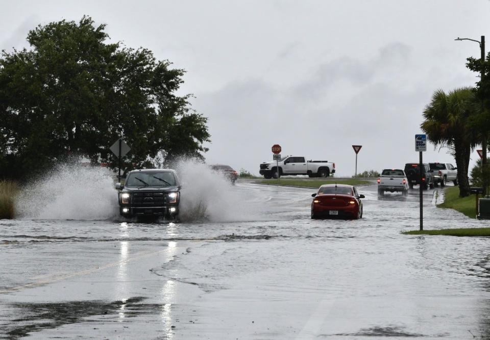
From Monday morning to Tuesday afternoon, some parts of northeast Florida received nearly 8 inches of rain, according to the weather service. The worst of the storms is expected to move off the Atlantic Coast by Tuesday afternoon, though intermittent showers and thunderstorms could hit northern Florida overnight.
2 people killed in Louisiana storms
In West Baton Rouge Parish, to the east of downtown Baton Rouge in Louisiana, one woman was killed when a tree fell onto a mobile home Monday night, according to local media reports. Officials in St. Martin Parish also reported a storm-related death but did not provide more information.
St. Martin Parish Sheriff Becket Breaux said in a Facebook video that based on the severity of the damage a tornado may have touched down in the area. Breaux and Henderson Mayor Sherbin Collette urged residents to stay off the roads and monitor weather updates.
"We have a lot of roads damaged; water across the roads, trees across the roads, debris all over the place," Collette said. "The damage at this point is really, really bad."

The week's forecast: Much of central, eastern US faces storm threats
Showers and storms over the Missouri, Mississippi and Ohio valleys were forecast to spread east through the mid-Atlantic and the Northeast on Tuesday, the weather service said.
The storms left a trail of flooded streets and overflowing rivers throughout parts of the central U.S., especially in Missouri, where two possible tornadoes formed Monday.
While the Northeast faces rounds of showers that could cause localized flooding, the Mississippi Valley got a brief respite from the poor weather. Beginning late Wednesday, however, the next round of showers and storms will begin to spread into the region.
Record heat in South Florida
Dangerously high temperatures are forecast to spread into South Florida this week as humidity punches the heat index into the triple digits.
Wednesday is forecast to be the warmest day: a daytime peak temperature of 95 degrees. The National Weather Service in Miami said the heat risk level on Wednesday is at a “significant” level, meaning the heat index, or “feels-like" temperatures, could rocket to 108-112.
The normal high temperature for mid-May is 85 to 86; the normal overnight low is 71.
The heat this week follows a handful of record-breaking hot days last week, including 97-degree temperatures Saturday. That broke the previous high temperature of 95 set in 2011. A 94-degree measurement on Thursday tied the record set in 1998.
Large hail, fierce winds recorded across the Southeast
While the weather service has not confirmed a tornado in St. Martin Parish, it reported a tornado in Calcasieu, about 100 miles west of St. Martin. Meteorologists recorded nickel and golf-ball-size hail in northern Florida and eastern Texas on Monday.
In Calhoun, Texas, on the Gulf Coast about 80 miles north of Corpus Christi, several campers and RVs were overturned during the storms, leaving at least two people injured, according to reports from the weather service.
From eastern Texas to the Florida Panhandle, torrential downpours caused waterways to rise several feet and dozens of authorities reported flooded streets and water damage impacting homes and businesses. Before Monday's storms unleashed rounds of downpours, streams and rivers were already near or at their flood stage, and much of the ground was soaked because of strong storms in recent weeks.
Contributing: Kimberly Miller, Palm Beach Post; Jim Little, Pensacola News Journal; Jorge L. Ortiz, USA TODAY
This article originally appeared on USA TODAY: Millions brace for another round of severe storms, tornadoes, flooding

