Hurricane season 2024: Rapid intensification of storms could be bad for Florida
As if the news couldn't get any worse.
Everyone is in agreement: The 2024 Atlantic hurricane season is going to be a bad one if all the predictions come true. Some are predicting more than double the average number of tropical cyclones thanks to La Niña and record warm water temperatures.
What's worse is the threat of "rapid intensification" of storms, which could give residents in the path of a hurricane little time to react.
Here's what AccuWeather meteorologists had to say about rapid intensification and why residents in Florida, Texas and the Carolinas especially should be aware.
What is rapid intensification when it come to hurricanes?
Rapid intensification is the term used to describe tropical storms and hurricanes that grow stronger over a short period of time.
Rapid intensification happens when a storm's maximum sustained winds strengthen by more than 35 mph over a 24-hour period.
That could make make a Category 1 hurricane a Category 4 hurricane. That's quite a difference when it comes to preparing and deciding to evacuate in the face of an approaching hurricane. Factor in a storm that undergoes rapid intensification right before landfall and you have a recipe for disaster, literally.
"Rapidly intensifying tropical storms and hurricanes are especially dangerous because they can give the public less time to prepare and often catch people off guard," according to AccuWeather.
What causes a tropical cyclone to rapidly intensify?
Let's start with the recipe for a hurricane, according to the National Ocean Service.
A pre-existing weather disturbance: A hurricane often starts out as a tropical wave.
Warm water: Water at least 79.7 degrees Fahrenheit over a depth of 164 feet powers the storm.
Thunderstorm activity: Thunderstorms turn ocean heat into hurricane fuel.
Low wind shear: A large difference in wind speed and direction around or near the storm can weaken it.
Several factors come into play that cause a tropical storm or hurricane to under rapid intensification. Those factors include:
Low wind shear.
Very warm water.
Abundant moisture.
Not every storm undergoes rapid intensification, but when the right conditions are in place, the chances are much higher, AccuWeather said.
Can forecasters predict when a tropical cyclone will undergo rapid intensification?
"Predicting a storm's peak intensity and its intensity at landfall is one of the most challenging aspects of weather forecasting, and a rapidly intensifying hurricane adds tremendously to that challenge," AccuWeather said.
"The general rule of thumb is that people prepare for one category up on AccuWeather RealImpact Scale for Hurricanes or the Saffir-Simpson Hurricane Wind Scale to allow for fluctuation in the strength of tropical systems," AccuWeather Hurricane Expert Alex DaSilva said.
"However, a danger exists when a tropical storm or hurricane is undergoing rapid intensification as the storm potentially could become much more powerful, dangerous and destructive than even that one-level buffer might account for."
How the threat of rapid intensification affects evacuations
The greater the population affected and the more dense of a population center, the more time is needed for preparations and mandatory evacuations, if necessary. A large, dense population center, such as New Orleans, may need at least 72 hours' notice in the event of a direct strike from a hurricane, according to NOLA Ready.
High winds and storm surge are the biggest concerns when it comes to rapidly intensifying storms since both could affect emergency planning and evacuation routes.
Who should be concerned about rapid intensification of hurricanes?
“This year we’re exceptionally concerned about the Texas coast, Florida Panhandle, South Florida, and the Carolinas,” DaSilva said.
“Storm surge and rainfall flooding are the deadliest threats from a hurricane. More people die from storm surge and flooding than the wind.”
AccuWeather Senior Meteorologist Dave Houk, who is a long-time Florida resident, is urging people to prepare now for tropical threats since they may have less time to react and evacuate.
"Proper planning and preparation prevent panic when a hurricane suddenly forms nearby or undergoes rapid strengthening," Houk said.
“The situation can quickly evolve with rapidly intensifying storms and that can impact your evacuation decisions,” said DaSilva.
“You don’t want to be scrambling last minute to get supplies and evacuate your family. Make sure you are prepared by the official start of hurricane season on June 1.”
Water temperatures across Atlantic basin 'have never been higher'
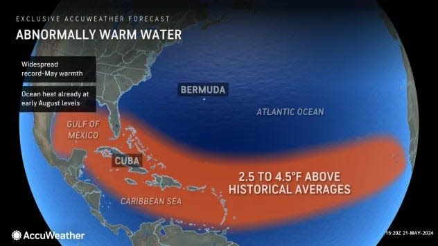
Water temperatures across the Atlantic basin — which covers the northern Atlantic Ocean, Caribbean Sea and Gulf of Mexico — are abnormally warm for May.
Water temperatures are setting records, with ocean heat 2.5 to 4.5 degrees above historical averages.
Temperatures in May are already as high as they typically are in early August, according to AccuWeather.
Sea-surface temperatures across the Atlantic basin have never been higher in recorded history for this date than they are right now, DaSilva said.
Water temperatures will continue to increase into early September.
"The fear is that as we enter the heart of the tropical season—from late August to early October—the sea-surface temperature may continue to eclipse last year's record-breaking season," DaSilva said.
"The warmer the oceans are, the more favorable the environment will be for tropical development and rapid intensification."
What are water temperatures right now around Florida?
The minimum temperature threshold for tropical development is about 80 degrees. Many areas of the Caribbean, Gulf of Mexico, and southwest Atlantic are already above that.
Current water temperatures today and compared to May averages, according to the National Centers for Environmental Information, are:
St. Augustine: 79.0; May average 75.6
20 miles east of Cape Canaveral: 82.0; May average, 77.3
Key West: 87.4; May average, 82.8
Fort Myers: 86.4; May average, 82.4
St. Petersburg, Tampa Bay: 83.5; May average, 81.7
Panama City Beach: 81.5; May average, 76.8
How deep warm temperatures go also plays role in hurricane strengthening
Tropical storms and hurricanes need warm water, but as they move, they churn up the water, pulling deeper water to the surface. That cooler water causes the intensity of a slow-moving storm to level off or weaken. But when water temperatures are warm well below the surface, that calming effect isn't present.
And that's where conditions are now. Temperatures in deeper waters are where they typically are in August.
"There is a patch in the Caribbean, near Jamaica, where 80-degree water reaches a depth of 600 feet this week," DaSilva said.
Those warm deep-water temperatures "is like rocket fuel for tropical cyclones," DaSilva said.
Hurricane Ian was a storm that underwent several phases of rapid intensification
On Sept. 28, Hurricane Ian went from a Category 3 storm with 120-mph winds to a Category 5 story with 160-mph winds in less than 24 hours and right before it made landfall at Cayo Costa in Southwest Florida as a Category 4 storm.
Hurricane Otis grew from Category 1 to Category 5 storm in one day
Another storm that underwent rapid intensification was Hurricane Otis in the Pacific. In October 2023, Otis' winds increased by 80 mph over a 12-hour period, according to the National Center for Atmospheric Research. The storm went from a Category 1 hurricane to a Category 5 storm in one day before making landfall at Acapulco, Mexico.
This article originally appeared on Naples Daily News: Hurricane rapid intensification. What it means for Florida

