2024 hurricane season: Forecasts all point to a busy season with La Niña and warm ocean temps
From the shimmering blaze of an overheated Atlantic Ocean to gales in the underbelly of the stratosphere, all evidence points to a highly active 2024 hurricane season that could rival the busiest years on record.
Forecasts that aim to predict the multitude and muscle of tropical cyclones ahead of the season's June 1 start date are in unsettling agreement, with some predicting more than double the number of average named storms and one labeling 2024 the “hurricane season from hell.”
The ingredients combining for a robust year include a rising La Niña and water temperatures in the runway between Africa and the Gulf of Mexico that are 3.6 to 7 degrees warmer than normal — a buffet of fuel for burgeoning systems.
At least one forecast points to a healthy African jet stream that could churn out tropical waves like a conveyor belt at warp speed. Another is already considering that the season could extend past its normal expiration date as in 2005 when Hurricane Epsilon formed in December.
Scary trend: Major hurricanes in October and November — why is it happening?
“I’m looking for some ray of sunshine in this forecast and I don’t see it,” said Weather.com senior meteorologist Jonathan Erdman. “This has all the makings of a potentially historic hurricane season.”
Yet, there is one atmospheric player in the high-stakes tropical affair that remains a wild card.
The Bermuda High, a yawning subtropical clockwise swish of winds in the Atlantic, was mostly a friend to the United States and the Caribbean last year, steering the bulk of the tropical systems north and out to sea. Although 2023 was an active season with 20 named storms, Idalia was the only hurricane to make landfall in the United States after originating far from the high’s reach in the eastern Pacific Ocean.
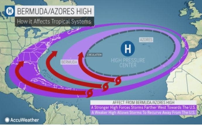
There are signs that the Bermuda High may be stronger and in a different position this year, which could mean more storms are lobbed farther west into the Caribbean, Gulf of Mexico and Florida. But the high is unpredictable and can’t be forecast accurately more than about two weeks ahead.
“If you got lulled to sleep by the last hurricane season, or just moved to Florida and have never experienced an active season, you better get prepared,” Erdman said. “This forecast makes it more urgent than ever to have a plan.”
'It's kind of incredible' expert says about high ocean temperatures
An average hurricane season has 14 named storms, which include seven hurricanes. Of the seven hurricanes, three are major hurricanes of Category 3 or higher.
As early predictions for this season started rolling in as far back as December, it became clear that there was little disagreement between them and higher confidence in the forecasts than in 2023.
WeatherBELL Analytics, which issued a forecast in December for up to 30 named storms and a “hurricane season from hell,” has stuck with that prediction. Colorado State University is predicting 23 named storms, the University of Pennsylvania is forecasting between 27 and 39 named storms, with a best estimate of 33, The Weather Company issued its most aggressive outlook since it began seasonal forecasting in 2006 with 24 named storms, and AccuWeather is predicting up to 25 named storms.
“Everyone has a lot of high numbers out,” said AccuWeather senior meteorologist Paul Pastelok. “When you see water temperatures the way they started in 2024 where they were two to four months ahead of schedule, it’s kind of incredible.”
Last year’s water temperatures were also abnormally warm, but there was an El Niño present. The periodic climate pattern acts to shred fledgling hurricanes in the Atlantic Ocean by increasing wind shear.
The setup of warm water and El Niño was billed as a clash of titans with forecasters uncertain how the hurricane season would unfold.
Erdman said the warm water temperatures won as evidenced by the formation of 20 named storms.
“This year, we have two factors working together and reinforcing each other,” Erdman said. “El Niño is on its last legs. It’s completely out of gas.”
NOAA’s Climate Prediction Center said in early May that La Niña could form as early as June but has a higher chance (69%) of developing between July and September. That corresponds with the peak of hurricane season mid-August through mid-October.
La Niña happens when Pacific waters cool, moving the location of where deep tropical thunderstorms form in the Pacific so that the wind shear in the Atlantic Ocean wanes during summer and fall. In winter, La Niña pulses storms into the Pacific Northwest on a more northerly and inland track, holding the jet stream at higher latitudes longer where it traps cold air to its north.
But there's no guarantee that the climate pattern will behave as predicted.
Bermuda High could save us or lead to ruin

“I would say there are subtleties that we can’t anticipate this early,” said Chris Davis, a senior scientist with the National Science Foundation’s National Center for Atmospheric Research. “We may be able to have some confidence in the number of tropical cyclones but we don’t have as much confidence in where they are going to go and what land they are going to affect.”
For the long-track Cabo Verde storms that stalk off the coast of Africa toward the United States and the Caribbean, the Bermuda High is often the main steering current. Last year, the high was feeble and positioned far to the east so that the storms slid around its western edge and out to sea.
VIDEO: El Niño, 'Godzilla', who protected Florida from hurricanes, is dead
Some storm experts gave credit to El Niño, in part, for weakening the high.
This year, some storm experts are concerned La Niña will stoke the high’s strength, meaning more storms could track into the western Caribbean Sea and the Gulf of Mexico.
Erdman said when The Weather Company looked at past years that had similar atmospheric set up to today, the storms traveled farther west.
Colorado State said 2020 is a comparable year. There were 30 named storms in 2020 — the highest on record and one that forced the World Meteorological Organization to change the way it names storms after the backup name list using the Greek alphabet proved confusing.
Eleven storms made landfall in the United States in 2020 including tropical storms Bertha, Cristobal, Fay and Beta, and hurricanes Hanna, Isaias, Laura, Sally Delta, Zeta and Eta.
“We could see a 2020,” Erdman said. “Unlike last year, there is a fertile breeding ground that will be made more favorable with La Niña.”
Register for the Palm Beach Post's 2024 Storm Season Preparation forum
The 2024 hurricane season is forecast to be one of the most active on record with most predictions calling for more than 20 named storms. To help our communities get prepared, The Palm Beach Post is hosting a forum on storm readiness Wednesday, June 5, from 6:15 to 8:30 p.m. at Palm Beach State College's Lake Worth Beach campus. To attend, please scan the QR Code to register or click this link.

Kimberly Miller is a journalist for The Palm Beach Post, part of the USA Today Network of Florida. She covers weather, real estate and how growth affects South Florida's environment. Subscribe to The Dirt for a weekly real estate roundup. If you have news tips, please send them to kmiller@pbpost.com. Help support our local journalism; subscribe today.
This article originally appeared on Palm Beach Post: Hurricane season 2024 is forecast to be one of busiest on record

