Where to photograph this week’s ‘ring of fire’ annular solar eclipse in America

A rare ‘ring of fire’ annular solar eclipse is coming to America this weekend. On Saturday, October 14, 2023, much of North and South America will enjoy a partial solar eclipse as the moon drifts across most of the sun’s disk over a few hours. However, for those lucky enough to be within a narrow 125 miles wide path, through the US Southwest, Central and South America we'll get to see something, much rarer – a ring around the moon that will last up to 5 minutes 17 seconds.
What is a ‘ring of fire’ annular solar eclipse?
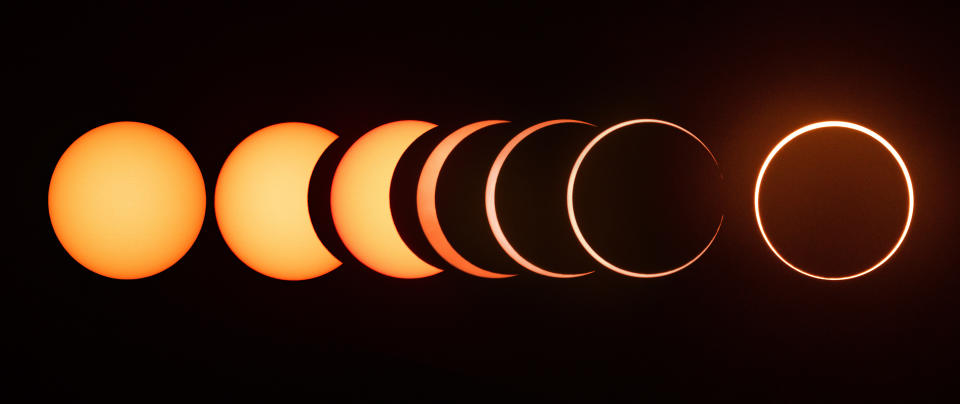
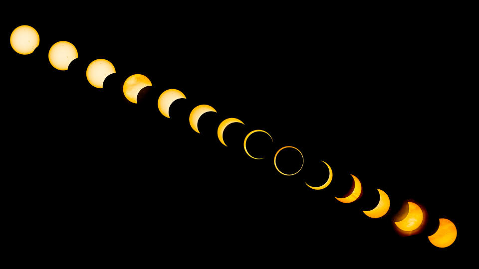
The ‘ring of fire’ is an annular (ring) solar eclipse. It occurs because the moon’s orbit of the Earth is elliptical, so its apparent size in our sky waxes and wanes throughout the month. Normally, this goes completely unnoticed. Even during a ‘supermoon’, when the moon is at its largest apparent size (something called perigee) it's a difficult thing to see. However, the apparent size of the moon becomes most noticeable during a solar eclipse. A total solar eclipse occurs when a perigee moon crosses the sun, while an annular solar eclipse is when an apogee moon—the furthest it can be from Earth—crosses only the central part of the sun. On October 14, 2023, up to 91% of the center of the sun’s disc will be covered by the moon to cause a ‘ring of fire’—in effect a pretty kind of partial solar eclipse.
Get ready with a pair of the best solar eclipse binoculars
Where the annular solar eclipse is happening?
Update 19 Sep 2023: It was announced on September 15, 2023 that Monument Valley Navajo Tribal Park and other parts of the Navajo Nation will be closed for a minimum of five hours (8 a.m. to 1 p.m.) on Oct. 14, during the annular eclipse, for eclipse observance by staff. This will also apply to the Four Corners Monument Navajo Tribal Park and to the management office at the Tséyi’ Diné Heritage Area-Cottonwood Campground (TDHA-CC) within Canyon de Chelly National Monument.
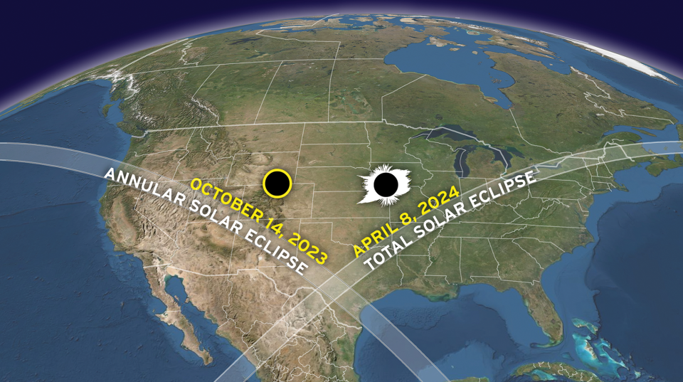
Although all of the Americas will enjoy a partial solar eclipse lasting about two-and-a-half hours, you need to be within the 125 miles wide path of annularity to photograph the ‘ring of fire’. Chronologically, it begins in the morning in Oregon on the US West Coast, before moving southeast across California, Nevada, Utah, Arizona, Colorado, New Mexico and Texas before it exits the US in the late morning.
The attraction of this vast area, of course, is its mess of national parks, state parks, and other spectacular locations for landscape photography. Iconic landscapes of the American West that the ‘ring of fire’ will be visible from include some of Utah’s most famous national parks, the iconic mittens of Monument Valley (see above), and the red rocks of the Four Corners region – not to mention some of the geological treasures of Oregon. As a bonus, many of them are International Dark Sky Parks, so prime locations for wide-field astrophotography.
After it departs the US, the ‘ring of fire’ will be visible from the Yucatán Peninsula in Mexico, Belize, Honduras, Nicaragua, (where, at 5 minutes 17 seconds, the maximum duration of the ‘ring of fire’ will occur) Panama, Colombia and Brazil.
Outside of that path, a number of big cities will enjoy huge a partial solar eclipse, including Denver at 78%, Las Vegas 82%, Dallas 80% and Salt Lake City 86%. New York City will see a 23% eclipse.
Photographing an annular solar eclipse
While an annular solar eclipse is less of a photographic occasion than the upcoming 2024 total solar eclipse (one of which will cross North America on April 8, 2024), the path of annularity this time is a gift to landscape photographers. The fact that you have to use a solar filter to photograph any partial solar eclipse (which, essentially, is what an annular eclipse is) makes it difficult to capture the event in the context of its environment. However, as an excuse for a landscape and astrophotography road trip with a bonus close-up of a ‘ring of fire’, it doesn't get much better than this.
Note that the closer you are to the centreline of the path, the longer the ‘ring of fire’ will last. However, celestial mechanics means that it varies from a maximum of 4 minutes 29 seconds at the Oregon coast to 4 minutes and 52 seconds as it leaves Texas. You should notice a drop in light levels when the sun is around 50% blocked by the sun.
Where's the best place to go?
‘Ring of fire solar eclipse’: where's the best place to go in the US Southwest?
It may not be strictly necessary for you to be somewhere iconic for the eclipse itself, but what better excuse to be in some of the best landscape photography locations in the US? Here are just a few highlights from a path of annularity that is stuffed with tempting places to go hang out with your camera:
Best places for dark night skies
Much of the path through the US Southwest is over sparsely populated land and at high elevation, so finding a Dark Sky Place won’t be a problem. It also helps that solar eclipses always take place at New Moon, when night skies are their very darkest.
Great Basin National Park, Nevada
9:24 am PDT for 3 minutes 29 seconds with the sun 27º above the southeast horizon.
Bryce Canyon National Park, Utah
10:27 am MDT for 2 minutes 18 seconds with the sun 30º above the southeast horizon
Capitol Reef National Park, Utah
10:27 am MDT for 4 minutes 37 seconds with the sun 30º above the southeast horizon.
Devils River State Natural Area (International Dark Sky Sanctuary), Texas
11:48 am CDT for 2 minutes 22 seconds with the sun 45º above the southeast horizon.
Best places for geological wonders
Whether it’s the deepest, bluest lake in the Americas or the strange hoodoos and pillars of the Colorado Plateau, the eclipse path holds multiple incredible photographic opportunities.

Crater Lake National Park, Oregon
9:17 am PDT for 4 minutes 23 seconds with the sun 19º above the east-southeast horizon.
Goblin Valley State Park, Utah
10:28 am MDT for 2 minutes 54 seconds with the sun 30º above the southeast horizon.
Goosenecks State Park, Utah
10:31 am MDT for 4 minutes 40 seconds with the sun 31º above the southeast horizon.
Best places for rare ‘edge effects’
If you position yourself at the edge of the eclipse path, the ‘ring of fire’ will last, but a few seconds, possibly a minute. However, what you can see from here that you cannot see near the centreline is Baily’s beads for many minutes before and after. It’s a bit of a geeky sight to chase, but eclipse-chasers swear by them…
Buck Canyon Overlook, Canyonlands National Park, Utah
10:30:42 am MDT for 28 seconds with the sun 31º above the southeast horizon.
Vista Grande Overlook, Santa Fe Ski Area, New Mexico
10:37:01 am MDT for 1.3 seconds with the sun 36º above the southeast horizon.
How to plan a trip to shoot the ‘ring of fire’
There are some major factors in choosing where to be to photograph any solar eclipse. Here’s what you need to think about:
The climate and likely weather on the day.
Having plenty of room to set up and use a tripod.
What shot you’re going for and the sight lines.
It's always interesting to capture the human side to events like this – such as people wearing eclipse classes, and using colanders to project crescent suns – but the ‘ring of fire’ is mostly something to zoom-on on, for which you’ll need a 200-500mm lens and solar filters, according to PhotoPills. Think about whether you’re going for a series of random shots or you want to get really organized and go for a sequence of phases.
With so much space available throughout the path, there’s little reason to attend huge viewing events, which in any case won’t be that numerous (after all, this is not a total solar eclipse).
Instead, focus on the climate when you’re planning (the Four Corners area has a 30% chance of cloud, which is about as low as it gets), but it’s far more important to check local weather a few days in advance because a cloudy sky during the eclipse will render this a non-event, photographically-speaking. Check out this interactive Google Map for positioning and eclipse duration, but also for the built-in PeakFinder links that will give you sight lines to the eclipse (probably only relevant for the Oregon and California part of the path).
Read more:
Astrophotography: How-to guides, tips and videos
Astrophotography tools: the best camera, lenses and gear
The best lenses for astrophotography
The best star tracker camera mounts
The best light pollution filters

