Unusual natural wonders that scientists can't explain
Mother Nature’s last great mysteries
Scope Images/Shutterstock
Scientific advancements mean we now have rational explanations for many of the world’s amazing landscapes. But some mysterious places around the globe continue to perplex experts. From a perfectly semi-circular lakeshore in Canada to a polka-dotted patch of earth in Namibia and a bright blue spring in France with no apparent origin, these beguiling natural wonders remain unexplained.
Read on for more mysterious places around the globe, from a perfectly semi-circular lakeshore in Canada to a bright blue spring in France with no apparent origin...
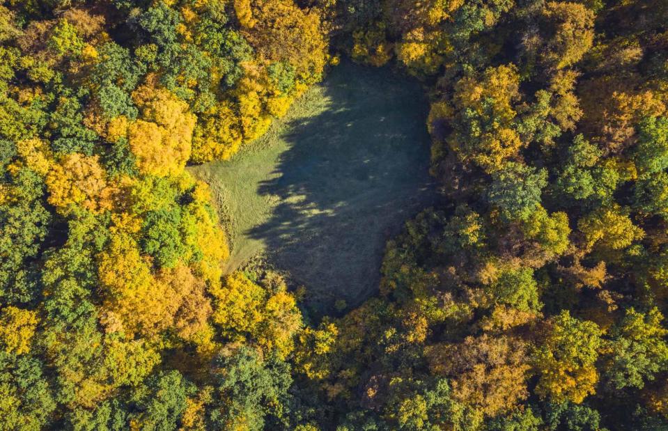
Hoia-Baciu Forest, Romania
salajean/Shutterstock
Under the right circumstances any forest could feel spooky, but Hoia-Baciu in Transylvania definitely dials things up a notch. Filled with crooked trees and carpeted by an eerie mist, the area has been dubbed ‘the Bermuda Triangle of Romania’ since there have been many tales of people going missing and other strange occurrences here. Horror stories aside, there’s an even bigger puzzle even scientists can’t explain...
In the heart of the woodland there’s a near-perfect circular patch, known as ‘the Clearing’, where nothing grows – and no one knows why. Outside of the circle, trees grow in strange, twisted forms. Various scientists have taken soil samples, studied the plant life and tested for radiation here, but their results have not yielded an answer as to why this desolate patch exists. One thing’s not up for debate, though: this forest will send a chill down the spine of anyone who ventures in.
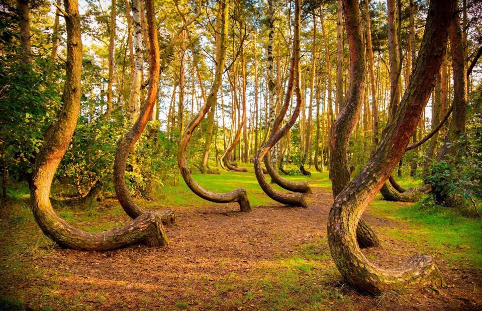
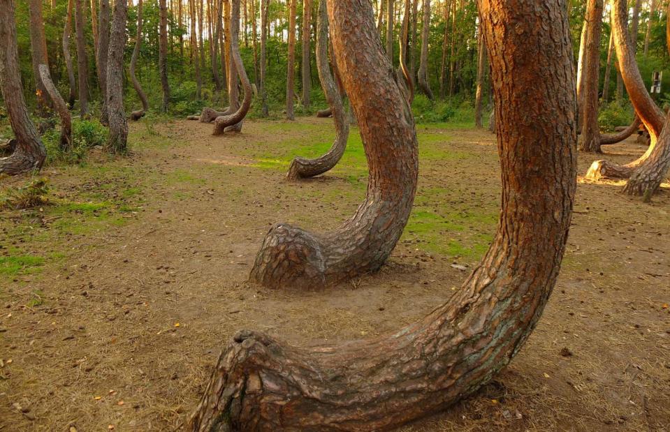
Crooked Forest, Poland
seawhisper/Shutterstock
With its J-shaped tree trunks, the aptly named Crooked Forest is as baffling as it is beautiful. Located near the Polish city of Gryfino, it’s home to more than 400 pine trees believed to have been planted in the 1930s and each displaying a curved trunk. Stranger still, the vast majority of them bend in a northward direction. Arboriculturists (tree scientists) have debated how this otherworldly landscape came to be but so far no one has been able to explain it.
Crooked Forest, Poland
Robert Szymanski/Shutterstock
One of the more outlandish theories was that this area has a unique gravitational pull which caused the trees to bend – an idea that was quickly dismissed. Another, slightly more plausible, hypothesis is that the trees buckled under the weight of heavy snowfall, but a patch of straight-trunked trees nearby seems to disprove this. It has also been suggested that there could be a genetic reason, although the smoothness and similarity of the curves makes this unlikely. For now, the fairy-tale forest remains a total mystery.
Fosse Dionne, France
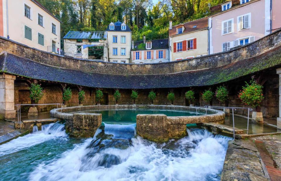
Herve Lenain/Alamy Stock Photo
Residents in the village of Tonnerre, in the heart of France’s Burgundy region, have been mystified by this bright blue spring for hundreds of years. The seemingly bottomless well gushes out around 311 litres (68 gallons) of water per second, yet its source has never been discovered. Cue plenty of local legends. One says its depths are patrolled by a huge, deadly serpent, while another suggests it’s a portal to other worlds.
Fosse Dionne, France
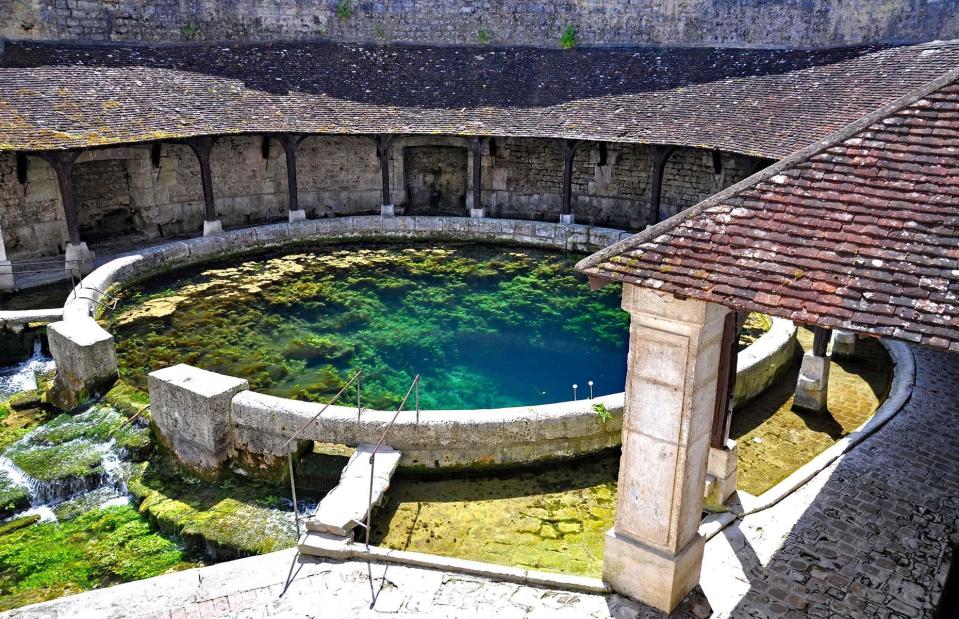
NORTH DEVON PHOTOGRAPHY/Shutterstock
In 1974, two hardy divers descended into the pit in an attempt to find the water's origin, but died while attempting to navigate its narrow passages. More than 20 years later, another diver went down into the well and met the same sorry fate. In October 2019, professional diver Pierre-Éric Deseigne was hired by the town to explore the spring, filming as he went. He managed to descend some 1,214 feet (370m) underwater, further than anyone had ever been before. But, while his footage gave some indication of what it’s like down there, he still couldn’t locate the spring’s source.
Richat Structure, Mauritania
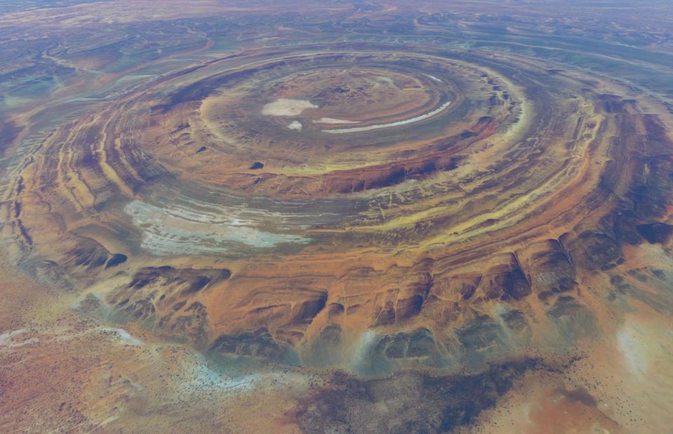
GLF Media/Shutterstock
This strange natural formation in the heart of the Sahara Desert only became widely known when we began sending humans into space. Dubbed Eye of the Sahara, because it appears to be gazing out to other planets, the Richat Structure was first captured on camera by astronauts on NASA’s Gemini IV mission in 1965. It’s thought that only a handful of local people previously knew of the geological oddity, which spans across a 25-mile (40km) region in Mauritania, northwest Africa.
Richat Structure, Mauritania
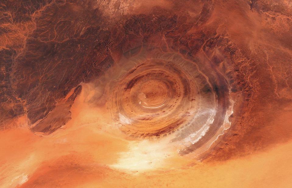
Trismegist san/Shutterstock
It was initially hypothesised that the natural wonder was created when a meteor crashed into Earth, but this idea was dismissed as there wasn’t enough melted rock in the area to show a collision. Today, the most prominent theory is that it was created more than 100 million years ago when the mega-continent of Pangaea was being forced apart. As the world’s tectonic plates shifted, molten rock pushed up to the surface but didn’t quite make it, resulting in the dome-like shape. Meanwhile, its concentric rings were created as different types of rock were eroded at different speeds.
Fairy circles, Namibia
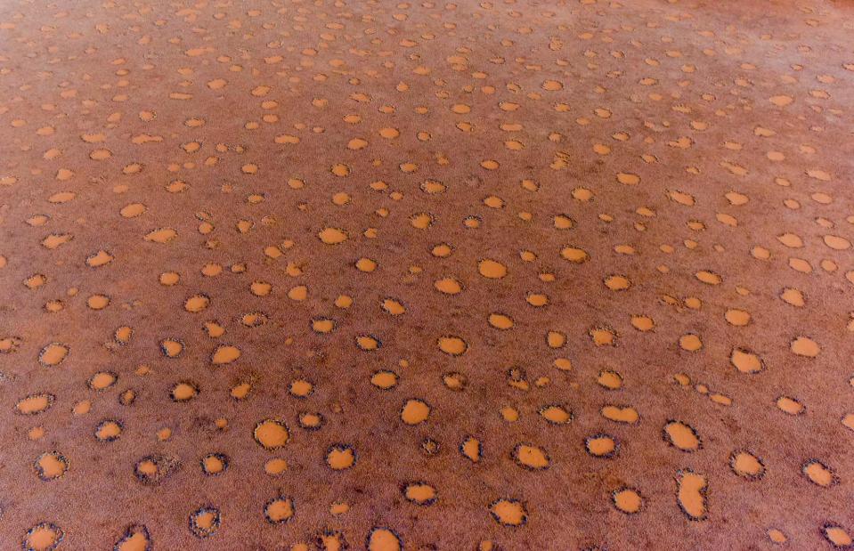
Felix Lipov/Shutterstock
Seen from above, the circular markings on this grassy desert in Namibia look like a vast sheet of polka dots. For hundreds of years, researchers have been unable to determine the cause of the fairy circles, which vary from 10-65 feet (3-20m) in diameter and extend across hundreds of miles. Local folklore states they’re the footprints of gods or that they were created by the breath of an underground dragon. But science has struggled to find a conclusive answer.
Fairy Circles, Namibia
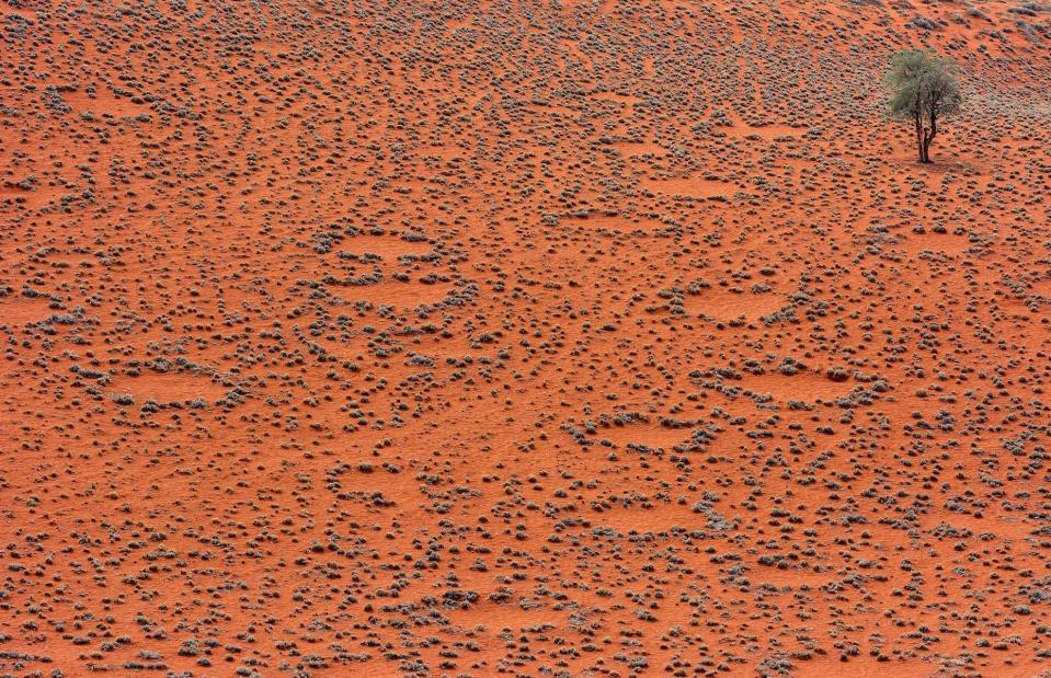
LUC KOHNEN/Shutterstock
One theory suggests that underground termites help to shape the circles, while another proposes that competition between different grasses in the desert is behind their formation. In 2021, a new study by researchers at the University of Pretoria argues that the distinctive markings are created as a plant releases toxic sap into the ground when it dies, stopping other plants from growing in these regions. The study’s authors noted that rising temperatures in Namibia may have fuelled increased competition between these plants, causing more of them to die and creating more fairy circles.
Carolina Bays, various states, USA
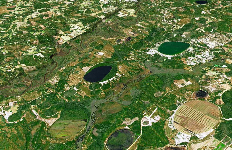
Joshua Stevens/Courtesy NASA Earth Observatory
From the ground, the wetland- and lake-filled depressions that make up the Carolina Bays on America's East Coast don’t look particularly unusual. So it wasn’t until the 1930s – when aerial photographs were taken of America’s Atlantic coastline for the first time – that their geological oddity became apparent. Resembling a series of oval-shaped depressions, which tend to be found in clusters and are filled with either water or vegetation, these egg-shaped forms all face in exactly the same direction.
Carolina Bays, various states, USA
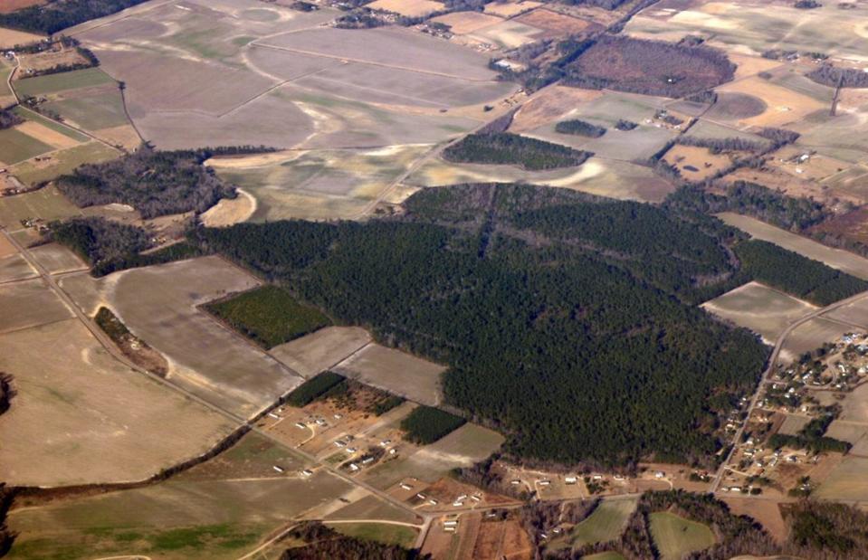
Public Domain/Wikimedia Commons
In the 1950s, scientists suggested that a meteor shower could have been responsible for their formation. But carbon-dating studies soon debunked this theory, revealing that the Carolina Bays were not formed at the same time, with some being tens of thousands of years apart. Another hypothesis states that, around 2.5 million years ago, strong southwesterly winds created currents on the surface of the ponds, which led them to deposit sediment on their north and southeastern sides. While this is considered the most likely answer, scientists still don’t know for sure.
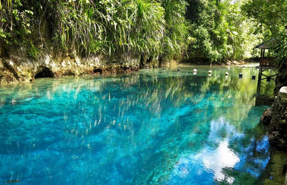
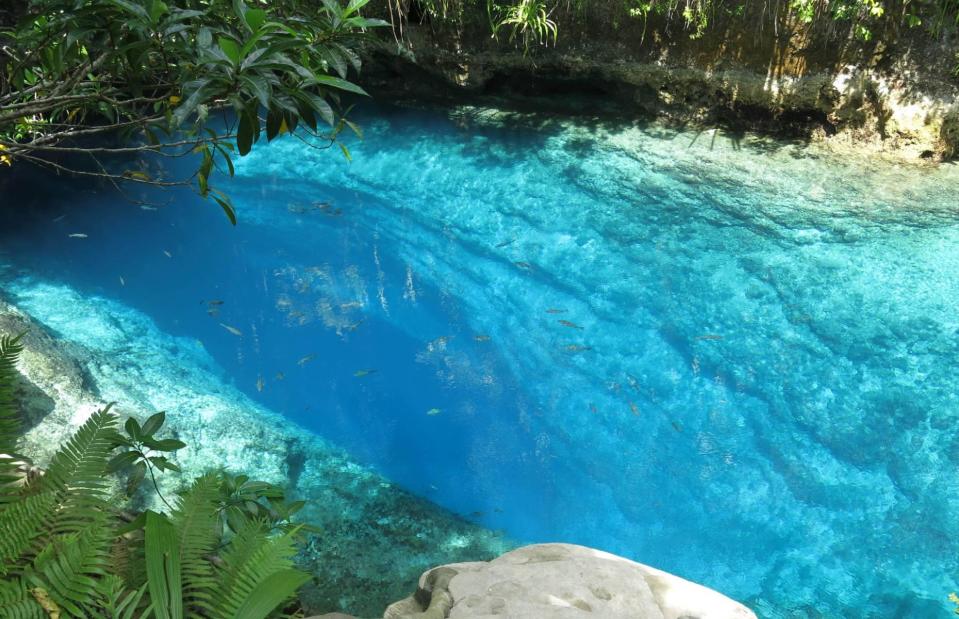
Enchanted River, Philippines
RicKy SantiAgo/Shutterstock
Enchanted by name and (apparently) enchanted by nature, this eye-popping blue river flows through an area of thick forest on the island of Mindanao in the Philippines. Local lore suggests the magical waters are inhabited by mythical creatures including engkanto (a kind of environmental spirit), and that sapphire and jade from fairies’ wands are responsible for its dramatic colour. But the biggest mystery of all is that this saltwater river has no apparent source.
Enchanted River, Philippines
RicKy SantiAgo/Shutterstock
The most convincing theory is that it was formed by seawater flowing through underground caves and resurfacing here. In the late 1990s, Filipino cave diver Alex Santos went down there and found a system of caves, which are thought to filter the water and make it crystal clear. In 2014 another diver, Alfonso Amores, dived down in an attempt to uncover more of the river’s secrets. But he didn't resurface, and his body was discovered in an underwater cave around eight hours later. For now, the river’s precise source and formation remains shrouded in mystery.
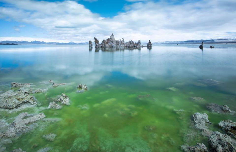
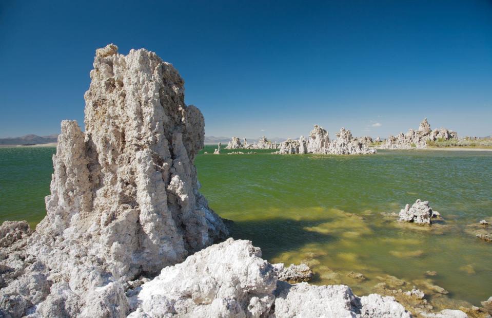
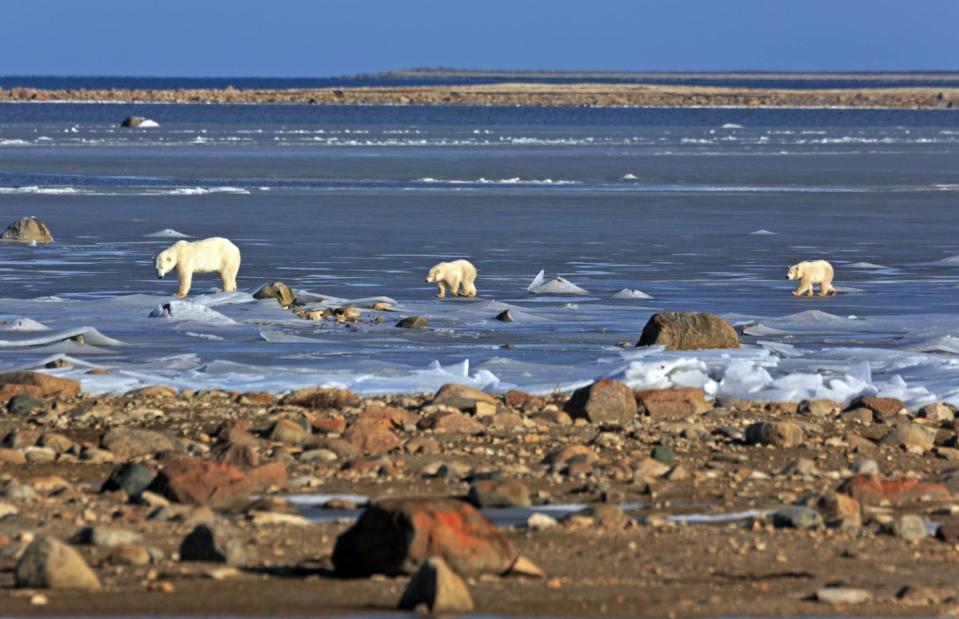
Mono Lake, California, USA
Cavan Images/Alamy Stock Photo
There are so many curiosities about California’s Mono Lake that it’s hard to know where to begin. For one, the 65-square-mile (168sq km) body of water is filled with hulking tufa towers which look like they've landed from Mars (they’re actually formed by underground springs). Another striking feature is its bright green hue. While it's know that this is a result of algal blooms, which reproduce due to the higher salt and alkaline levels that occur when the lake dries up, there’s still some mystery surrounding this process.
Mono Lake, California, USA
Scope Images/Shutterstock
The green algae usually get their energy from photosynthesis, which requires sunlight. But scientists’ samples found algae even right at the bottom of the lake, where it’s almost completely dark. This suggests that the conditions of the lake are creating remarkably tolerant algae, which can produce oxygen without sunlight, although further studies are needed to confirm this. Adding to the list of weird things scientists have found at the lake, an ‘otherworldly’ species of worm with three sexes was recently discovered there.
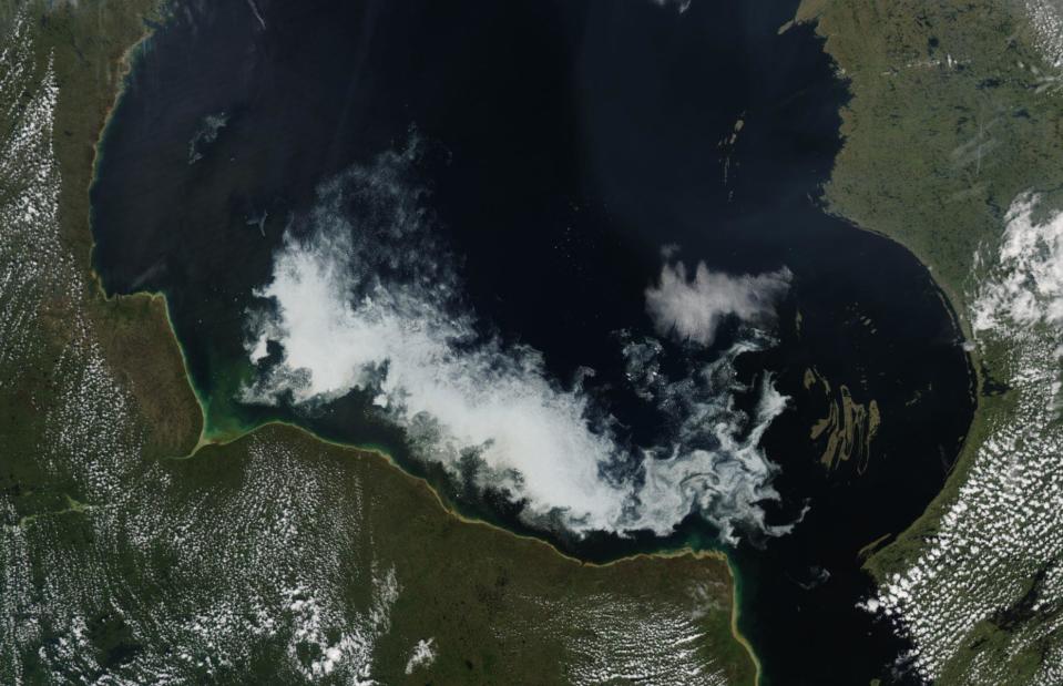
Nastapoka Arc, Quebec, Canada
NASA/Public Domain/Wikimedia Commons
Also known as the Hudson Bay Arc due to its location on the eastern edge of the inland sea, the Nastapoka Arc is a bizarre geological feature that no one quite understands. Seen from the skies, it resembles an almost perfect semi-circle, as if a giant cookie cutter were used to separate the land. The strange feature in northern Quebec was found by sailors on British ship Discovery, which drifted into the bay in 1611.
Nastapoka Arc, Quebec, Canada
Bildagentur Zoonar GmbH/Shutterstock
Amazed by the smoothness and regularity of the shape, scientists initially suspected Nastapoka Arc was formed by a meteor. But two American geophysicists, who travelled here in the 1970s to study the arc, found no evidence to support that theory. Today, the prevailing idea is that the bay is a tectonic boundary, created when one rock shelf was pressed under another.
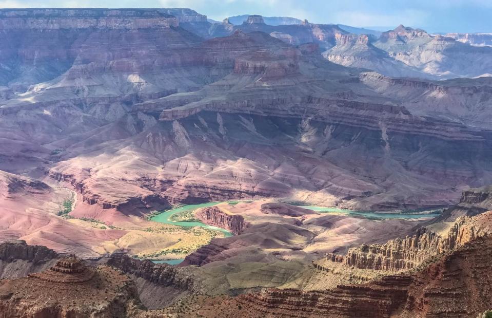
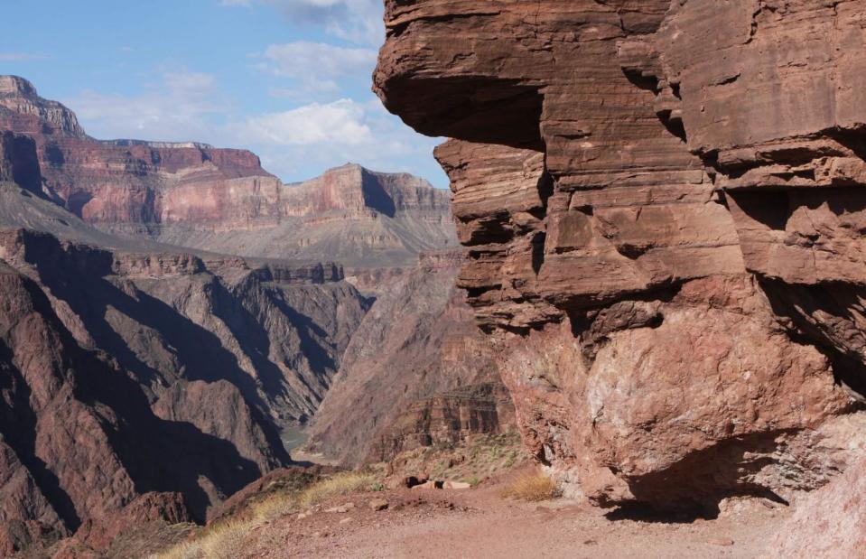
The Great Unconformity, Arizona, USA
Nate Loper/Shutterstock
Since the Grand Canyon is one of the most-visited places in the US, you’d think we know everything there is to know about it. But that isn’t strictly true. In fact, this stunning natural wonder is home (or, rather, not home) to a weird phenomenon known as the Great Unconformity: a gap in the layers of rock indicating an unaccounted-for period of 250 million-1.2 billion years. This geological gap has been found in other regions across the world but the reason for its presence is thought to vary from place to place.
The Great Unconformity, Arizona, USA
brewbooks/CC BY-SA 2.0/Flickr
Scientists can be certain that there is a gap because of the large disparity between the ages of the rock layers around it. While it’s still unclear how exactly it came to be, researchers have put forward the theory that the rock layers were lost during a period of tectonic uplift, when the ancient supercontinent Rodinia broke apart some 750 million years ago. They suggest that this rifting created the faults in the rock we can see today. Researchers are also studying similar ‘unconformities’ across North America to find out what’s behind these mysterious periods in the planet’s history.
Yamal Craters, Russia
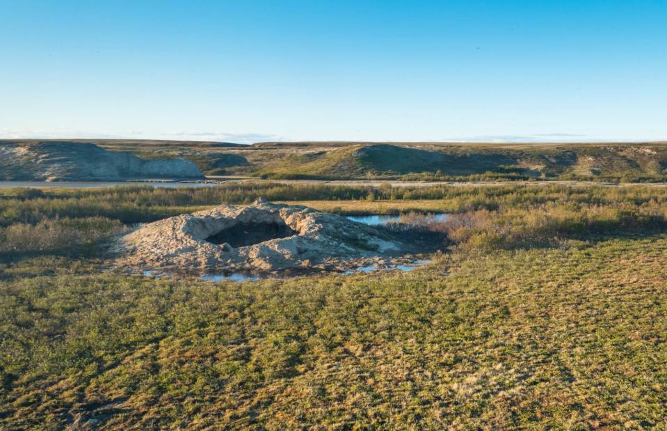
V. Belov/Shutterstock
On a remote Siberian peninsula in the Arctic Circle are a series of enormous craters which are literally exploding into existence. The bizarre natural phenomenon which creates the holes, known as the Yamal Craters, was first observed by scientists in 2014. At the time, they said such a feature had never been seen before in permafrost (ground that remains frozen for more than two years). There are currently 17 such craters in the region in west-central Russia, all of which have come into being within a decade.
Yamal Craters, Russia
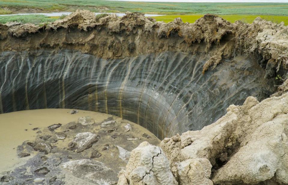
Aleksandr Lutcenko/Shutterstock
How the craters are formed largely remains a mystery. It’s widely speculated that climate change plays a role, as the rapid melting of permafrost has been responsible for many other drastic changes in the Arctic ecosystem. At the moment, researchers know that the explosions were caused by gas, which builds up under the tundra for several years before breaking apart the land. However, it’s still unclear where the gas comes from in the first place.
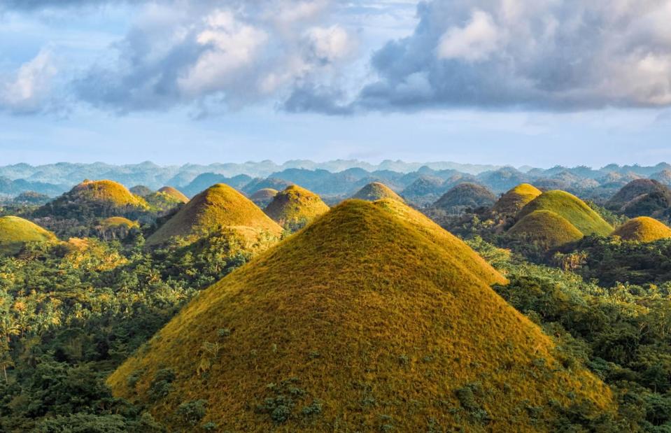
Chocolate Hills, Philippines
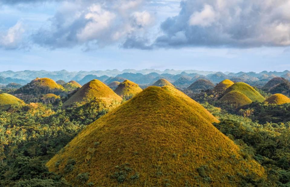
Pelikh Alexey/Shutterstock
So-named because they resemble little mounds of chocolate in the dry season – when their grassy coverings go from verdant green to brown – these otherworldly hills have puzzled scientists for decades. The peaks, which spread across 19 square miles (50sq km) on the island of Bohol in the Philippines, vary in size but have strikingly similar and symmetrical shapes as if created in moulds.
Chocolate Hills, Philippines
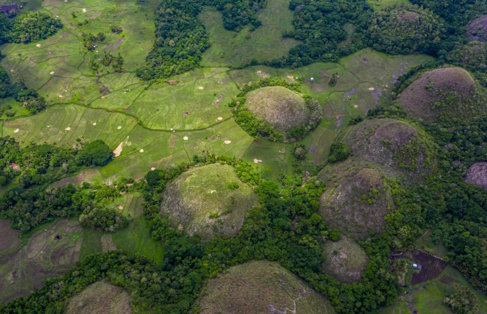
Avigator Fortuner/Shutterstock
The most widely accepted hypothesis is that the hills were formed by the weathering of limestone. As tectonic plates shifted, the limestone was lifted above sea level and the hills were gradually sculpted by rain, wind and erosion. Another theory is that the hills are in fact former coral reefs, brought above sea level due to a geological shift. Myths and legends on the island provide plenty of other ideas, suggesting they were formed by the tears of a heartbroken giant – or that they were created when two battling giants threw rocks at each other.
Want more myths and mysteries? Discover the most magical places on Earth

