The New Triple Crown: Meet the Next Best Long Trails
This article originally appeared on Backpacker
Hiking the Triple Crown is an amazing feat, but North America is home to more than just the Appalachian, Pacific Crest, and Continental Divide Trails. Long trails criss-cross the continent, and can take you across nearly every region and ecosystem in North America. Few are as well-known or developed as the Triple Crown trails are, and when you tell your friends you're quitting your job to hike, say, the Hayduke Trail, you're likely to get blank stares. But that's part of the appeal: The most popular thru-hikes are, let's face it, getting crowded. In comparison, lesser-known long trails are opportunities for real adventure--the kind that require routefinding, problem solving, and embracing the unknown.
Backpacking a lesser-known long trail is like taking a step back in time. Do you wish you could hike the Appalachian Trail as it used to be, when the shelters weren't packed shoulder-to-shoulder, and A Walk in the Woods was just an idea in Bill Bryson's head? If so, set your sights on one of these up-and-coming routes. All three are hikeable today, though there's some bushwhacking, compass wrangling, and road walking to be had. But when it comes to embarking on a "New Triple Crown", that's all part of the fun.
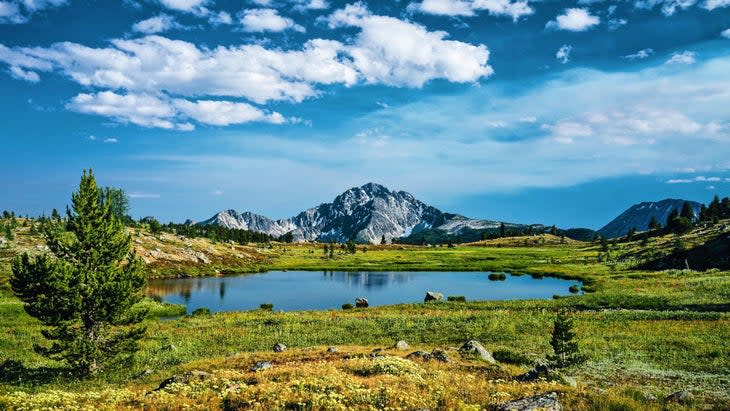
Pacific Northwest Trail

At a Glance
Length: 1,200 miles
Ideal Start Date: Late June or early July
Highlights: Crossing two of the country's proudest mountain ranges
Challenges: Routefinding--much of the trail is unmarked and unsigned.
The Pacific Northwest Trail is one of the newest members in an exclusive club--America's growing collection of National Scenic Trails. Running about 1,200 miles from the Continental Divide in Montana to the Pacific Ocean in Washington, the trail is a highlight reel of all there is to love about the American West: alpine peaks, temperate rainforests, high desert scrub, and immense solitude.
"The PNT is first and foremost a wilderness trail," says Eric Wollborg, a 2016 PNT thru-hiker who is now the communications director for the Pacific Northwest Trail Association. "It passes through some really remote country--amongst the most remote landscapes in the lower 48."
Though the number of PNT thru-hikers has been steadily climbing (Wollborg says there are now about 100 thru-hikers each year, compared to a dozen in 2016), a trip along it is still a lesson in solitude. Thru-hikers are likely to see more bears than fellow humans, not to mention wolves, lynx, and other life-list wildlife.
The PNT might be a newer trail, but the idea behind it traces back to the 1970s and a man named Ron Strickland, who was a tireless advocate on the trail's behalf. After identifying a route, Strickland convinced Congress to look into national trail designation in 1976. A year later, he founded the PNTA. In 1979, the National Park Service and U.S. Forest Service released a study that examined the costs and impacts of designating the PNT as a National Scenic Trail and opted against it.

Rather than giving the agencies the last word, Strickland got back to work, organizing volunteers, raising funds, and spreading the trail's gospel. In order to publish the trail's first guidebook, he thru-hiked the PNT himself in 1983. After some 30 years of grassroots effort, officials could no longer resist the on-the-ground reality: The Pacific Northwest Trail did exist, and it was worth protecting. In 2009, it became an official National Scenic Trail.
Today, the PNTA is a dedicated non-profit with a staff of five. The organization also hires about 50 seasonal trail workers each year, mostly high schoolers and twenty-somethings from trail-adjacent communities. Together with hundreds of volunteers who organize more than 50 trail work events each year, the PNTA is slowly but surely reopening out-of-commission trails, rerouting the PNT off jeep roads, and realizing its goal of a continuous wilderness trail from Glacier to the Olympic Peninsula. As of now, Wollborg says about one-third of the trail remains on forest and paved roads, but that percentage is dropping every year.
One thing that's common among those helping to develop the PNT is that they don't want it to change too much.
"When people hear 'National Scenic Trail', they tend to think there's going to be uniformity, like the national highway system," says Wollborg. But the PNT is designed to feel remote and primitive, and there are no plans to change that. Much of the trail is so narrow that the Appalachian Trail and Pacific Crest Trails seem like sidewalks in comparison. That's by design. Established campsites are often few and far between, too.
That means one of the biggest goals of the PNTA is to help "manage expectations," Wollborg says. "The PNT is not signed on the ground, it’s not blazed. You're definitely going to be referring to maps or GPS more often."
Most hikers attempt the trail east to west, heading toward the coast. The journey begins in Glacier National Park, where the PNT shares a few miles with the Continental Divide Trail, and snow can hold on until midsummer. For a more flexible start date, an increasing number of thru-hikers now opt to flip-flop, starting in Oroville, Washington near the midpoint of the trail and circling back around to complete it later. This allows hikers to tackle the desert section in early summer while the snow melts in the mountains.
No matter how hikers choose to approach the PNT, there's plenty of remote and inspiring terrain to experience. In the Idaho Panhandle, hikers cross the craggy and isolated Selkirk and Purcell mountain ranges. In central Washington’s Pasayten Wilderness, thru-hikers will cross the third-longest roadless stretch in the national trail system, bested only by the Bob Marshall Wilderness on the CDT and a section of the Sierra Nevadas on the PCT.
"The PNT packs a ton of variety in what's actually a pretty short thru-hike," says Wollborg. "It climbs up and over ranges instead of along the spine, so you're passing through rainforests and rain shadows." Within a few days of travel, hikers will not only cross imposing mountain passes, but watch the ecosystem change before their eyes. It all adds up to an awe-inspiring experience that can leave thru-hikers feeling lost in time.
"Hiking the PNT is like tackling the PCT or CDT in the 1970s," Wollborg says. "There are problems for you to solve, there's some adventure to be had. You won't always know what to expect, and that's part of the experience."
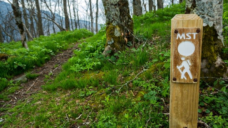
Mountains-to-Sea Trail

At a Glance
Length: 1,175 miles
Ideal Start Date: September or October
Highlights: A taste of everything the East Coast has to offer, from 6,000-foot peaks to wetlands and beaches
Challenges: There's a lot of road walking.
One of the challenges for any long trail on the East Coast is avoiding people. With a majority of Americans living east of the Mississippi River, it can be hard to find solitude. One eastern trail that's made peace with that reality is the Mountains-to-Sea Trail: Over its 1,175-mile length, there's plenty of natural splendor to enjoy, from the Blue Ridge Mountains to the beaches of the Outer Banks. But the trail also embraces civilization by routing hikers along main streets and through the historic towns of North Carolina.
"The MST is a little different," says Brent Laurenz, the executive director of Friends of the Mountains-to-Sea Trail, the non-profit dedicated to the trail. "From the outset it was never designed to be a purely wilderness trail. One goal was to connect the communities."
The MST was first conceived in 1977 by Howard Lee, the secretary of the North Carolina Department of Natural and Cultural Resources. His idea was suitably grand: a path that traveled the width of the state, beginning in Great Smoky Mountains National Park and ending on the shores of the Atlantic Ocean. As with other long trails, decades passed before the path existed on the ground. In 1997, Friends of the Mountains to Sea Trail formed to spur new interest in completing the trail. In 2000, North Carolina incorporated the trail into its state park system, and progress has continued ever since.
Crossing the state west to east, the MST offers more diversity than hikers might expect from an East Coast trail. It summits Mt. Mitchell, the highest point east of the Mississippi, as well as the East Coast's tallest sand dune in Jockey's Ridge State Park.

"Despite what people might think, you're not just walking through a hardwood forest most of the time," says Laurenz. Instead, there are three distinct sections that make up the MST: First, the mountains, which center around long climbs, expansive views, and dense forests. Central North Carolina is the Piedmont (or foothill) region, where hikers will traipse through farmlands, woodlands, and historic towns. Finally, the coastal region features wetlands, sand flats, and marshes, culminating with beach walking along the barrier islands of the Outer Banks.
Tara Dower, who thru-hiked the MST in 2020--setting the women's fastest known time in the process--enjoyed the mountainous western section most of all. But she says the rest of the trail surprised her, especially once she reached the coast: "It was a lot of beach walking, but it was quiet, peaceful, and a completely new experience."
Dower says the MST makes for a perfect spring or fall hike. In the heat of summer, bugs can be overwhelming, especially as you near the coast. In the southern Appalachians, snow isn't a worry until the dead of winter. It's reasonable to hike the trail in either direction, but heading west leaves the best for last. The western terminus is atop the observation tower at Clingman's Dome, with 360-degree views of the Smoky Mountains.
As for challenges? The sheer amount of road walking is one. While about 725 miles of the trail are on trails or paths, that still leaves some 450 miles on pavement.
"I’d recommend a red flashing light on the back of your pack and a high visibility vest," says Dower, adding that traffic on some roads was faster than she expected.
There are ways around the road sections. One option is to paddle: there are water trails on the Yadkin River and Neuse River that together total nearly 200 miles. These mostly replace sections of road walking, and are considered an official part of the trail. Some hikers have also opted to bike, skateboard, or push a scooter along lengthier road segments, though choosing any of those options requires some logistical maneuvering.
Laurenz and his colleagues at Friends of the MST are, of course, hard at work rerouting the trail off the roads wherever they can. By their estimates, that's happening at a rate of about 15 miles per year. Volunteers are also crucial to maintaining and building the trail. Twenty volunteer trail crew leaders each maintain a segment of the trail, and manage groups of volunteers--over a thousand in total. Together, those volunteers contributed more than 44,000 hours of trail work last year.
Laurenz stresses that while the MST isn't particularly rugged or remote, it takes more planning than hikers might expect.
"It does require some pre-planning," Laurenz says. "Camping and lodging opportunities can be complicated. Once you get to the coast, you have to catch a ferry a couple times. There are a lot of little things like that."
Great Divide Trail

At a Glance
Length: 750 miles
Ideal Start Date: Late July
Highlights: The grandeur of the Canadian Rockies
Challenges: Routefinding, bushwhacking, and grizzly bears
The Great Divide Trail picks up where the Continental Divide Trail leaves off--quite literally--at the edge of Glacier National Park. But while the CDT is already the most remote and logistically challenging of the Triple Crown trails, it is just a taste of what's to come north of the border. The Great Divide Trail might be only 750 miles long, but it packs a punch: While the mountains in this part of the Canadian Rockies don't have the sheer elevation of the highest peaks in Colorado or California, they're rugged and prominent enough that it's easy to forget that. The Great Divide Trail traverses five national parks including dream-trip candidates like Banff, Jasper, and Yoho, and crosses the Divide 30 times.
"It's 750 miles of 'wow'", says Doug Borthwick, who thru-hiked the GDT in 2010, and now volunteers as the president of the Great Divide Trail Association's board of directors. "Other trails I've hiked have certain sections that are amazing, but the scenery on the GDT is nonstop."
Unsurprisingly, the idea of a path through the Canadian Rockies has captivated hikers' imaginations for quite some time. The concept first materialized in the 1960s when the Girl Guides, Canada's analogue to the Girl Scouts, proposed it. From there, the idea gained traction, and Parks Canada signed on, approving a plan to complete the trail by 1975. Within a few years, however, the agency had scrapped the plan, and the trail languished for years. A guidebook published in 2000 by Dustin Lynx reignited interest in the trail, and in 2013, the Great Divide Trail Association (which had formed in the 1970s but dissolved in the intervening years) reestablished itself. That, plus the newfound surge in thru-hiking's popularity over the past decade, means the Great Divide Trail is back on the map and ready for adventurous hikers to explore.
Still, It's difficult to put into words just how difficult this trail really is. Though some stretches are on well-maintained national park trails, that's the exception, not the rule. There are many places where faint trails disappear altogether, leaving hikers to travel by map across ridgelines, burn scars, and timber cuts. River crossings can be dicey, and the GDT is grizzly country from start to finish. If anything goes wrong, help is probably a long way off.

There's also a lot to plan. Since navigation is difficult, thru-hikers need to be prepared with paper and GPS maps to find their way. Wildfires and other trail closures could leave hikers figuring out reroutes on the fly. Then there's the hiking season itself--which only extends from July to September in an average year.
Austin Hager, a 2021 GDT thru-hiker who now leads GDTA's outreach program, devotes a lot of his time to educating and informing hikers about the challenges they'll face. "Living in British Columbia, we kind of forget that not everyone is used to the wildlife and terrain that we have," he says. Every year, he runs a webinar series for prospective hikers, detailing challenges like weather, trail conditions, and animal encounters. The big takeaways? Bear spray is non-negotiable. Neither is planning.
"The hardest thing about the trail is the logistics," says Borthwick. One especially tricky aspect of the GDT is the lack of a thru-hiker permitting system. That's because Canada has no National Scenic Trail system, and the GDT is not an official trail by the letter of the law. Without that, thru-hikers are left scrambling for the same uber-popular national park campsites that everyone else is, and must keep to a strict schedule in order to reach each campsite on the correct date. Borthwick says rectifying the confusing permits and getting an official trail designation are top priorities at the GDTA.
For hikers who come prepared, those challenges are a big part of the appeal. The extreme remoteness also means more wildlife encounters, especially in the northern stretches, where roads and other human visitors are increasingly rare. Hikers have reported run-ins with not only grizzlies, but moose, lynx, wolverines, and endangered woodland caribou.
As is the case with any dedicated trail organization, the GDTA is hard at work maintaining and rerouting the trail. In 2020, the group completed a seven-year project called the High Rock Trail, which moved 30 miles from forest roads onto brand-new singletrack. Today, about 80 percent of the GDT is purpose-built trail (the remainder is about an even split between forest roads and cross-country routefinding), but organizers and volunteers want to bump that number even higher.

Best of all, the Great Divide Trail isn't done expanding. Today, there are several northern endings to choose from. Officially, the trail extends to Lake Kakwa, though many hikers finish their journeys in Mount Robson Provincial Park due to logistical challenges getting back on the trail to the north. Hager suggests going all the way.
"The entire feeling of that last section is hard to describe," he says. "It's roadless, so you'll be hiking 10 or 11 days without a resupply or break. It's the best chance to see wildlife, due to the solitude. It almost feels like the rest of the trail was preparing you for this."
But one day, even Lake Kakwa might not be the end of the journey. Lynx noted that he thinks the trail could extend even further by adding another 125-mile stretch and finishing among the glaciers and waterfalls of Monkman Provincial Park. And Hager notes that making it accessible is a priority for the GDTA.
"Many people are apprehensive about hiking the trail," says Hager. "As a thru-hiker and now a volunteer, that kind of hurts. We know it's a difficult trail, but we want to make sure if people want to experience it, there are ways to do it, whether that's on a thru-hike, a section hike, or a dayhike. The trail is for everyone."
For exclusive access to all of our fitness, gear, adventure, and travel stories, plus discounts on trips, events, and gear, sign up for Outside+ today.

