Torreys Peak: The Ultimate Hiking Guide
- Oops!Something went wrong.Please try again later.
- Oops!Something went wrong.Please try again later.
Backpacker
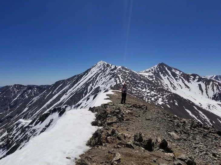
Thanks to its breezy standard hiking route and its proximity to the Denver metro area, 14,267-foot Torreys Peak remains one of Colorado’s most popular 14ers to summit. Combining it with Grays Peak makes for a classic 14er adventure: The two summits are less than a mile apart and joined by a pleasant Class 2 ridgewalk. Claiming two ranked 14,000-foot summits in a single hike is part of the appeal.
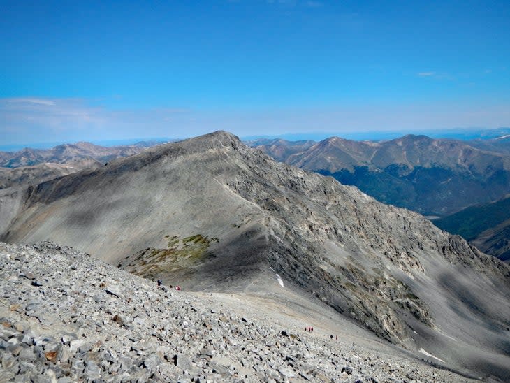
That means an average year sees 20,000+ visitors to Torreys Peak. The majority of these hikers take the standard route out of Stevens Gulch--a gorgeous hike that starts by passing mining ruins from the early 1900s before ascending through willows to break treeline into an open alpine basin. Hikers eventually reach a high ridge on the Continental Divide with wide views of the Rocky Mountains to the west and flat prairie land to the east. Most hikers top out on the shorter Torreys first before traversing over to 14,278-foot Grays Peak.
But beyond the standard route lie several options that offer more challenge and bypass the crowds. For thrill-seekers, Kelso Ridge offers a Class 3 scramble that culminates in a brief but exciting knife-edge traverse just below the summit. Endurance-driven hikers can summit Torreys by the west ridge connecting it to 13,427-foot Grizzly Peak D (so-named because it is the fourth-highest mountain in Colorado with the name "Grizzly Peak"). Strong hikers can add 13,850-foot Mount Edwards to the mix by traversing to or from Argentine Pass. And those looking for an all-day epic can aim for the daunting Loveland Pass to Guanella Pass Traverse: One of the most ambitious treks in the Front Range, it covers seven summits over 13,000 feet in elevation in a bruising 13.7 miles and 6,638 feet of elevation gain.
A Very Brief History of Torreys Peak
Torreys Peak is named for John Torrey (1796 – 1873), a well-liked and highly accomplished scientist who has been referred to as America's first botanist. (If you happen to summit Torreys Peak on August 15th, raise your water bottle as you celebrate John Torrey's birthday.)
Torrey's student Asa Gray (1810 – 1888) went on to have a botany career equally as distinguished as his mentor. The two are immortalized on the neighboring peaks. Gray taught at Harvard University and counted Charles Darwin as a personal friend. He visited Darwin in 1868 at the latter's home in England to discuss the emerging idea of natural selection.
Both summits were named by fellow botanist Charles C. Parry. Parry made the first recorded European ascents of the peaks in 1861. Torrey never climbed the peak named in his honor but did see it from afar in 1872, a year before his death. Asa Gray also first saw Grays Peak in 1872, but the energetic 62-year-old actually climbed to the summit of his namesake mountain.
Gear & When to Hike
Torreys Peak is best climbed from June – early October. Afternoon thunderstorms are always a concern, so getting on the trail before 6 a.m. is wise. Climbing on summer weekdays or in shoulder season can mitigate Torreys’ constant traffic. Mid-September is a sweet spot: The weather is cool, thunderstorms are less likely, and autumn's palette decorates the basin’s willows in blazing hues of yellow, orange, and red. Snow can be on the peak year-round, and most years should be expected until mid-June.
Day hiking trail shoes are fine for the standard route and on Kelso Ridge, but longer traverse options with sections of unstable rock like the West Ridge are better suited for full hiking boots. As with all Colorado mountain hikes, bring at least 48 ounces of water, plenty of snacks, and warm clothing layers (hat, gloves, shell) as storms can come at any time of year. Sunscreen and UVA/UVB-rated sunglasses will keep the high-altitude sun from scorching your skin and eyeballs.
Altitude Considerations
Torreys Peak is high enough for serious altitude sickness risk. Most people who live over 5,000 feet in Colorado can do the hike without much discomfort, but they aren’t immune. Out-of-towners should take two to three days to acclimate at 7,000 – 9,500 feet before trying the peak.
Anyone attempting the long traverses should be acclimated and have a high level of fitness. The Loveland Pass to Guanella Pass traverse never drops below 11,670 feet, and most of the route is above 13,000 feet.
Torreys Peak Hiking Routes
Note: There may be minor discrepancies in distance and elevation, as is common in GPS tracking.
Standard Route – Grays and Torreys Peaks via Stevens Gulch
The classic way up Torreys Peak. Most hikers include a walk over to Grays Peak before descending.
Difficulty Medium
Class 2
Distance 8.1 miles out-and-back
Estimated Time 5 – 7 hours
Directions & Trailhead GPS
Grays & Torreys Trailhead 39.66149, -105.78476
From I-70 take Exit 221 for Bakerville. Go south off the exit to FS Road 189 (this is the winter parking area). From here it is 3 miles up a bouncy, rutted road to the trailhead. Passenger cars are not advised, though they can drive up 1 mile to the Grizzly Gulch turnoff and park there. Summer hikers should aim to be at the parking lot by 5 AM. As of 2021, Clear Creek district rangers are enforcing occasional weekend and holiday closures on the access road below the parking lot. When these closures are in effect, hikers must park down farther on the road either at the Grizzly Gulch pull-off or the winter parking area.
About the Hike
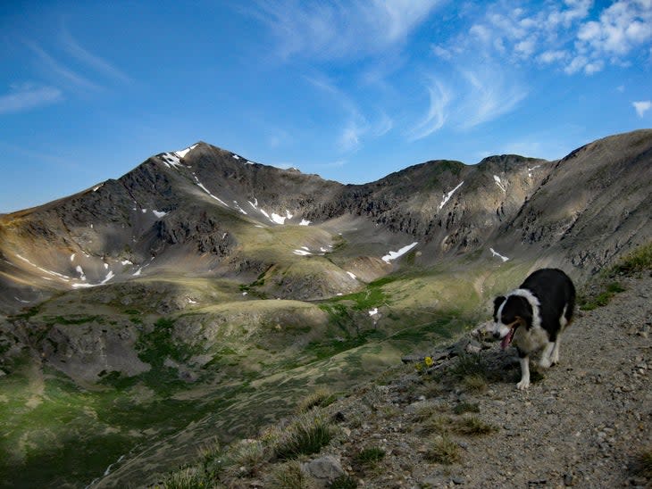
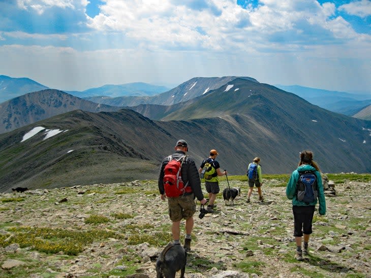
There will be crowds, especially on summer weekends. Try to get out on a weekday or in the autumn shoulder season from September through October. Still, the popularity of this hike doesn't diminish from the incredible scenery and breathtaking views from the summit ridge. Stevens Gulch is an amazing glacial curl that has been smoothed out enough to offer accommodating passage to Grays and Torreys Peaks.
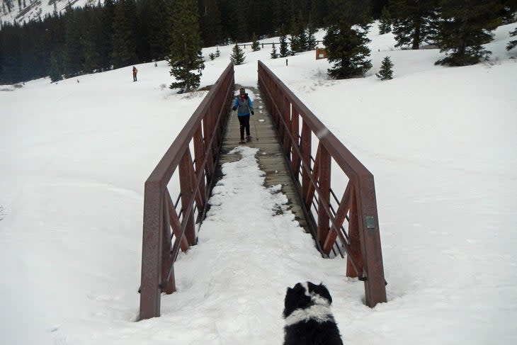
Starting from the Grays and Torreys Trailhead, cross a well-built wooden bridge and begin the hike through fields of willows and shrubs. Soon both towering summits will be in view. Continue above treeline, eventually switchbacking up a well-worn trail to Grays Peak. From there, traverse over to Torreys Peak. There are trails the entire way, and the connection between the two peaks will be obvious. After summiting Torreys, return to the saddle and drop down an access trail that saves a little distance when regaining the main trail back to the parking area.
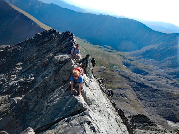
Kelso Ridge via Stevens Gulch
Kelso Ridge is a Class 3 ridge that ups the exposure in brief sections. This direct line up Torreys Peak is a classic scramble that is a good introduction to Colorado’s Class 3 terrain.
Difficulty Hard
Class 3
Distance 6.5 miles lollipop loop
Estimated Time 5 – 7 hours
Directions & Trailhead GPS
Grays and Torreys Trailhead 39.66149, -105.78476
Kelso Ridge shares a trailhead with the standard route on Grays and Torreys. See above for directions.
About the Hike
Start your hike on the Grays and Torreys Trail. Two miles in, diverge from the main trail to the northwest along a well-traveled (but unmarked) social trail. This short path brings you to the saddle of Torreys Peak and Kelso Mountain.
This is where the real fun begins: Torreys peak looks intimidating from this vantage point. Head west along the ridge--it is 0.9 miles to the top from here. There will be a braid of climbers' trails, but there is no single "right" trail. Stay as close to the top of the ridge as possible, but a few easy Class 3 scrambles can be navigated on the sides, where easier terrain awaits. The crux of the scramble is a brief but highly exposed 20-foot-long knife-edge that connects the ridge with the top of spooky Dead Dog Couloir that demands full attention.
Downclimb into the Dead Dog Couloir notch and enjoy an easy walk up to the summit from there. Return via the standard Grays and Torreys route, tacking on Grays Peak as an optional summit if you're feeling it.
Grizzly Peak – Torreys Peak Traverse via Loveland Pass
This unique route explores Torreys west ridge, a Class 2+ scramble with an approach hike that grabs two 13ers en route. While this route is better done as a traverse, it's possible to do it as a long out-and-back.
Difficulty Medium/Hard
Class 2+
Distance 8.5 miles out-and-back
Estimated Time 7 – 9 hours
Directions & Trailhead GPS
Trailhead GPS 39.66389, -105.87907
This hike begins from the paved parking area at the top of Loveland Pass. Take Exit 216 off I-70 and follow the paved pass south about 4 miles past the Loveland Ski Area parking lot. There is overflow parking on the south side of the pass, just note the hike itself begins at the highest parking lot at the signed summit atop the pass.
About the Hike
The route here is listed as an out-and-back, but finagling two vehicles to do this as a point-to-point to the Stevens Gulch Trailhead saves a lot of time and 2,500 feet of elevation gain. Even if you leave a car at the bottom of the Stevens Gulch access road, it's only a 3 mile downhill hike from the Grays and Torreys Trailhead.
If you're going for the out-and-back, start before 5 a.m.; you will be above treeline the entire hike. Begin the ascent up to the ridge to the east via a well-worn trail. Before reaching the highest point on the ridge, detour off right (southeast) to a connector trail that will gain the open, broad ridge. The next 1.5 miles is a pleasant walk that passes over 13,117-foot Cupid Peak before leading to a Class 2+ downclimb to the saddle to the north of Grizzly Peak.
Scramble up 13,427-foot Grizzly Peak via a climbers' trail and reach your second summit of the day. Now the real work begins: It's about 1.5 miles from here along a boulder-strewn, Class 2+ ridge to Torreys Peak. Scrambling along this route can be slow-going as there is no formally established trail. At mile 4.3, top out on Torreys Peak. If you’ve left a vehicle at the Grays and Torreys Trailhead, take the standard route up Torreys down. If not, reverse your route, reclimbing Grizzly Peak and the scrappy scramble back up to Cupid.
By the time you reach Cupid for a second time (at mile 7), the rest of the walk down will go quickly.
Torreys – Mount Edwards Traverse via Argentine Pass
This out-and-back scramble starts at the ghost town of Waldorf and traverses over 13,850-foot Mount Edwards and Grays Peak en route to Torreys. It's also possible to modify the route by starting on the opposite side of Argentine Pass and taking the Class 3 route up Gray Peak's south ridge.
Difficulty Medium
Class 2
Distance 9.8 miles loop
Estimated Time 7 -9 hours
Directions & Trailhead GPS
Waldorf Townsite Trailhead GPS 39.63777, -105.76604
You will need high clearance 4×4 to get to this trailhead. Stock SUVs with enough clearance and off-road-ready tires can handle this drive. Drivers of sport-utility crossovers like the Suburu Forester or Honda CRV should consider the alternate route from the west side of Argentine Pass.
From the town of Georgetown, take Guanella Pass 2.5 miles up to the abrupt turn off to the dirt road that is Leavenworth Creek Road.
The first 1.1 miles of this road (FS 352) is steep, rutted, and loose with tight switchbacks. 4-low is a good idea for 4 or 6-cylinder vehicles. At mile 0.9, there is a very tempting smooth road that goes straight that you must ignore (it is listed as 248.1B). This road is for Jeeps and modified vehicles--it will absolutely bash stock SUVS and trucks.
Rather, go right up what seems to be a terribly steep and loose hill. At the top of this hill, turn left and enjoy a smooth 4×4 road for 4.2 miles to the large open ghost town of Waldorf. A large parking area past a metal structure is the trailhead. While 4×4 roads continue up from this point (including to Argentine Pass), this is where SUVs / trucks should park.
About the Hike
After the exciting drive up, hike up to the today of Argentine Pass and turn north along a gentle ridge to hit your first objective, Mount Edwards. From here it's a simple out-and-back to Grays Peak then Torreys Peak along the Continental Divide on Class 2/2+ ridge.
Though it's not really practical, this could be done as a point-to-point leaving a car at the Stephens Gulch parking area at the Grays and Torreys Trailhead. That would involve a second punishing drive up to Waldorf to retrieve your vehicle.
Option 2 via Western Side of Argentine Pass & Grays Peak South Ridge
Argentine PassTrailhead GPS 39.60926, -105.79975
This route is also possible from the Argentine Pass Trailhead on the west side of the pass. It also mixes it up with an ascent of Gray Peak's south ridge (Class 2), then the traverse to Torreys. Go back to Grays then continue on to Mount Edwards and fresh terrain down to Argentine Pass.
To get there, start from US 6 at Keystone Resort and turn east onto Montezuma Road. Go 4.2 miles on this paved road to the turnoff for CO 260 (Peru Creek Road). This dirt road is rutted but relatively flat and passable by sport-utility cars, SUVs, and trucks. Follow it 4.5 miles into Horseshoe Basin and a small parking area where the Argentine Pass Trail begins.
About the Hike
Begin the hike by hiking north on the Peru Creek Road high into Horseshoe Basin. Leave the road and gain the eastern spur that connects to Gray Peaks south ridge, south of the small chain of ponds listed as Grays Lake on topo maps. There are some social trails here but no formal trail.
Top out on Grays Peak and meander over to Torreys Peak. Return to Grays Peak then go due east along a Class 2+ ridge to Mount Edwards. From here, turn southeast to Argentine Pass and take the beautiful trail southwest back to the parking area.
Loveland Pass – Guanella Pass Traverse
This is a huge day that gains over 6,500 feet of total elevation and nabs seven summits over 13,000 feet. Difficulty never exceeds Class 2+, but you'll need great endurance (and two vehicles) to complete this epic traverse.
Difficulty Hard
Distance 13.7 miles point-to-point
Class 2+
Estimated Time 9 – 11 hours
Directions & Trailhead GPS
Loveland Pass Trailhead GPS 39.66389, -105.87907
Gunanella Pass Square Top Lakes Trailhead GPS 39.59750, -105.71282
Your "start" vehicle will be at the Loveland Pass Trailhead (see above for directions). Your "finish" vehicle will be parked at Guanella Pass. These are both paved roads. For the finish parking, start in Georgetown and drive Guanella Pass 11 miles to the top parking area. The extremely popular (and likely full) Mount Bierstadt Trail is on the east side of the road. Your parking lot, Square Top Lakes, is on the west side of the road.
Pro tip: This huge day is made easier if you have pals hiking Mount Bierstadt who can give you a lift back to your vehicle at the end of the day.
About the Hike
This incredible ridgewalk is strictly for strong, acclimated hikers. It extends the Loveland Pass route beyond Torreys and Grays to go over Mount Edwards, Argentine Peak, and Square Top Mountain. The navigation is relatively simple--you're following the Continental Divide. From Argentine Pass to Square Top Mountain, there are no formal trails but the way is straightforward.
The difficulty never exceeds Class 2 but this is a big outing with close to 7,000 feet of vertical elevation gain. It's worth starting very early for this hike, 2 a.m. at the latest, as you'll be above treeline the entire time. Saving this one for September or even early October will help hikers find the sweet spot of longish days and lower chances of thunderstorms.
For exclusive access to all of our fitness, gear, adventure, and travel stories, plus discounts on trips, events, and gear, sign up for Outside+ today.]]>

