Take a Scenic Drive Near the Grand Canyon
This article originally appeared on My Grand Canyon
Grand Canyon National Park is only the beginning.
The terrain surrounding Grand Canyon, through which visitors travel through on their way to and from the country’s most popular natural wonder, varies from deserts and canyons to mountains and ancient ruins. There are scenic drives in all directions.
If your itinerary allows, we recommend visitors travel different routes to and from Grand Canyon National Park. The best way to experience the spectacular and unique country that surrounds and makes up the Grand Canyon is to drive through it.
Retrace Route 66 in Arizona with Side Trips to Big Lakes
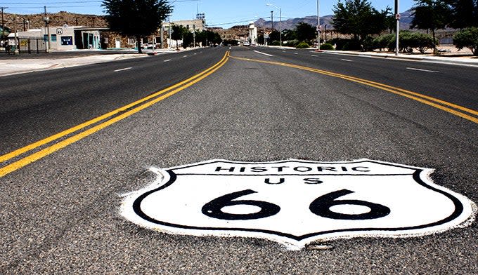
Historic Route 66 dates back to 1926, the year highways were first marked in this country. It has its longest stretch in, you guessed it, Arizona. From Las Vegas, you can drive 33 miles to Lake Mead National Recreation Area on US 93 and US 95. On Lake Mead, you can kayak, canoe, swim, rent boats and cool down from the hot summer sun. You’ll also want to visit Hoover Dam, the enormous hydropower facility that gave rise to Lake Mead.
From there, head to the legendary Route 66 by first stopping in Kingman, Ariz., home to the Route 66 Museum, which is definitely worth visiting. In addition to exhibits on the Mother Road, you can explore the gift shop full of Route 66 souvenirs. There’s Mr. D’z Diner across the street that looks like it is straight out of the 1950s, including its menu.
From Kingman, travel west on Highway 66. You’ll drive through ghost towns and old mining towns. Peach Springs is home to the Hualapai Nation and once a terminal of the Santa Fe Railroad, to Grand Canyon Caverns and Seligman, where the route rejoins the Interstate 40.
You’ll also reach Williams, Ariz., on I-40 where music streams from nearly every street corner and Route 66 signage and memorabilia line the streets and storefronts. From Williams, you are just under an hour from the South Entrance to the Grand Canyon by car. Or leave your car in Williams and take the Grand Canyon Railway to the park, a fun-filled trip that includes a reenactment of the Old West with robbers played by actors coming on board the train only to be confronted by the town sheriff.
Drive through Oak Creek Canyon and Stop at a Swimming Hole
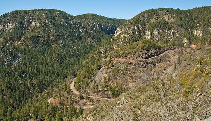
Another fantastic scenic drive is Oak Creek Canyon, which connects Flagstaff, Ariz., with Sedona via a serpentine road that clings to the walls of the canyon in its descent to Sedona. From Flagstaff take Route 89A. The road was originally built in 1914 and then paved in 1938. This 15-mile drive one-way offers beautiful views from the top of Mogollon Rim on down through the canyon. It’s actually hard to believe such a lush area exists in a land of little water and wide open dry landscapes. It was the agricultural potential of the area that attracted Frank Pendley to the canyon where he planted his first apple orchard in 1912 seven miles from Sedona. His irrigation practices are still in effect today in what is now called Slide Rock State Park, which has been called one of America’s top 10 swimming holes. Put on your jeans and slide down the famously smooth slide rock for a refreshing plunge or just wade in the creek’s pools.
After you have dried off, head farther down the canyon to Sedona where the town’s legendary vortexes await you. Said to bring about mental clarity and peace, Sedona’s four vortexes are scattered around the area and are accessible. They include Cathedral Rock, Boynton Canyon, Bell Rock and Airport Rock. The easiest one to get to is Airport Rock at the bottom of Airport Mesa where you can literally park in front of it at the bottom of the hill leading to the airport. If the parking lot is full, drive up Airport Road to the top of the mesa and park in the lot up there. Follow the dirt path along the airport’s chainlink fence down for a 20-minute walk to Airport Rock. This is a fantastic place to watch the sunset in the evening, but arrive early to get a good spot on the rock as dozens of other visitors will have the same game plan as you.
Cruise the Red Rock Scenic Byway
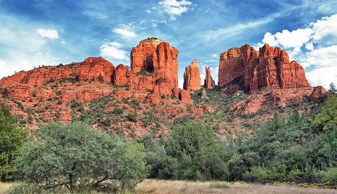
If you are in Sedona, the Red Rock Scenic Byway is another great drive. From Uptown Sedona, head south on Highway 179. This stretch is only eight miles but the drive is full of striking red rock country. It actually is Arizona’s first “All-American Road” named by the U.S. Department of Transportation. Along the way, you can stop at Cathedral Rock, one of Sedona’s vortexes and a great hike. A mixture of rock scrambling and a dirt path leads you up to the base of Cathedral Rock where you can see for miles in several directions. It’s a great hike for people of all ages who are fit and old enough to handle one steep rock scrambling section that has a 15-20-foot drop on one side.
Tour the San Francisco Peaks Scenic Road
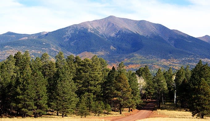
From Flagstaff, you can drive the 44- mile loop road about the San Francisco Peaks when the road is open,which is usually late March through early November, depending on snow conditions. Bring a lunch and picnic blanket and stop along the journey to take in the wildflowers growing in the summer and the colorful aspens during the fall. From Flagstaff, drive northeast 14 miles on US 89 to Forest Road 418. Turn west 12 miles to Forest Road 151. Then go south 8 miles to US 180. It’s 9.5 miles back to Flagstaff. Depending on how many stops you make, the drive will take 2 to 3 hours or longer.
Drive Through Monument Valley
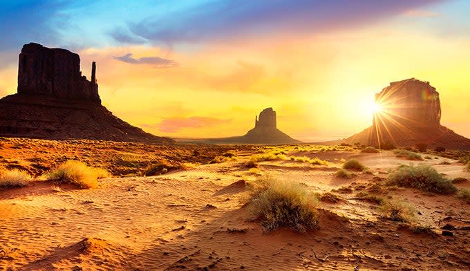
Monument Valley, which straddles the southern border of Utah and northern border of Arizona, is often called America’s most scenic drive. It’s full of spectacular, towering red rocks (“monuments”) that thrust out of an otherwise vast and stark “Mars-like” landscape. The tallest of red-rock formations stretches 1,000 feet high. You can drive along Highway 163 from Kayenta to Mexican Hat for free, or pay an access fee and do the 17-mile loop on Valley Drive in the Monument Valley Navajo Tribal Park. It costs $20 per car with a maximum of four people. Children 9 and under are free.
You also can purchase guided jeep tours with Navajo guides at the park’s visitor center. Check the Navajo website for summer and winter scenic drive hours. The visitor center is 1 mile east of U.S. Highway 163 on the Arizona-Utah border.
For exclusive access to all of our fitness, gear, adventure, and travel stories, plus discounts on trips, events, and gear, sign up for Outside+ today.

