Powerful Nor'easter To Slam Northeast With Heavy Snow Starting Tomorrow
Ski The East's Instagram account posted something today that has skiers all over the Northeast quaking in their ski boots.
With a snow forecast detailing the storm rolling in over the next couple days, Ski The East wrote, "About time Ullr 🙌 @yawgoo valley we’re coming for ya 🎿"
Tomorrow morning, things will start getting dicey as over half a foot accumulates throughout the day for areas across the East Coast.
Sadly, it doesn't look like my home state of Maine will be benefitting much from this storm cycle, but Massachusetts, Connecticut, and Rhode Island are going to get dumped on.
In other words, things are looking good for Jiminy Peak, MA, Wachusett Mountain Ski Area, MA, Mohawk Mountain, CT, Mt. Southington, CT, and Powder Ridge, CT, and Rhode Island's Yawgoo Valley (which the Ski The East crew is striking!) among others.
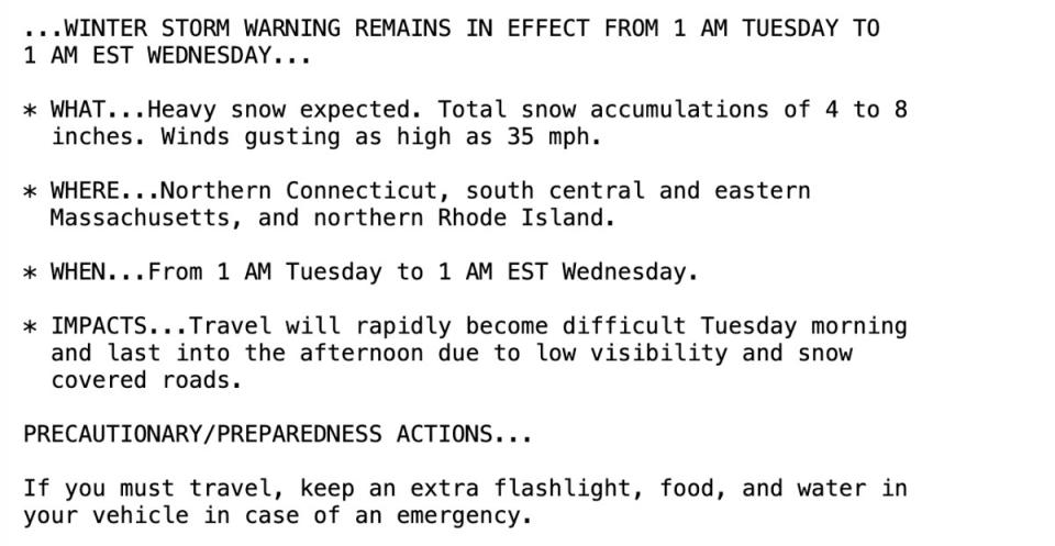
The National Weather Service administered a Winter Storm Warning that is in effect from 1am Tuesday until 1am Wednesday (EST, of course)!
The winter storm even made its debut on Good Morning America.
New York will even see the "heaviest snow in over two years" according to The New York Times.
Beginning late Monday and going into Tuesday, heavy snow is predicted to fall across the Northeast, with some areas expected to get up to two inches of snow an hour.
The NY Times highlighted that "the band of heaviest snow will fall from northern New Jersey to southern New England. Cities like Boston are likely to receive a foot of snow or more."
Additionally, The Washington Post reported that "winter storm warnings are in effect for much of the Northeast ahead of a powerful nor’easter that will bring heavy snow, strong winds and coastal flooding late Monday night and Tuesday."
"Some areas could be pasted by a foot of heavy, wet snow, including Hartford, Conn.; Providence, R.I.; and Boston."
The sweet spot for accumulating snow will probably stretch from central Pennsylvania through southern New York and Connecticut into southeastern Massachusetts, where at least 8 to 12 inches could fall between Monday night and Tuesday.
At this time, "over 40 million people are under winter weather alerts from the panhandle of West Virginia to southeastern Maine."
And skiers in those areas are under skip-school-and-work-to-ski alerts.
We're stoked for you East Coasters to not have to brave the ice this week! And unlike the carnage Tahoe sees every time there's a storm, we're not too worried about those East Coast powder chasers driving up to the mountains... they're used to bad roads! Get after it!
Related: Utah Ski Resort Measures 30+ Inches Of New Snow
Don't miss another headline from POWDER! Subscribe to our newsletter and stay connected with the latest happenings in the world of skiing.
We're always on the lookout for amusing, interesting and engaging ski-related videos to feature on our channels. Whether you're a professional or just an amateur, we want to see your best footage and help you share it with the world. Submit your video for a chance to be featured on POWDER and our social channels. Be sure to subscribe to our YouTube channel to watch high-quality ski videos.

