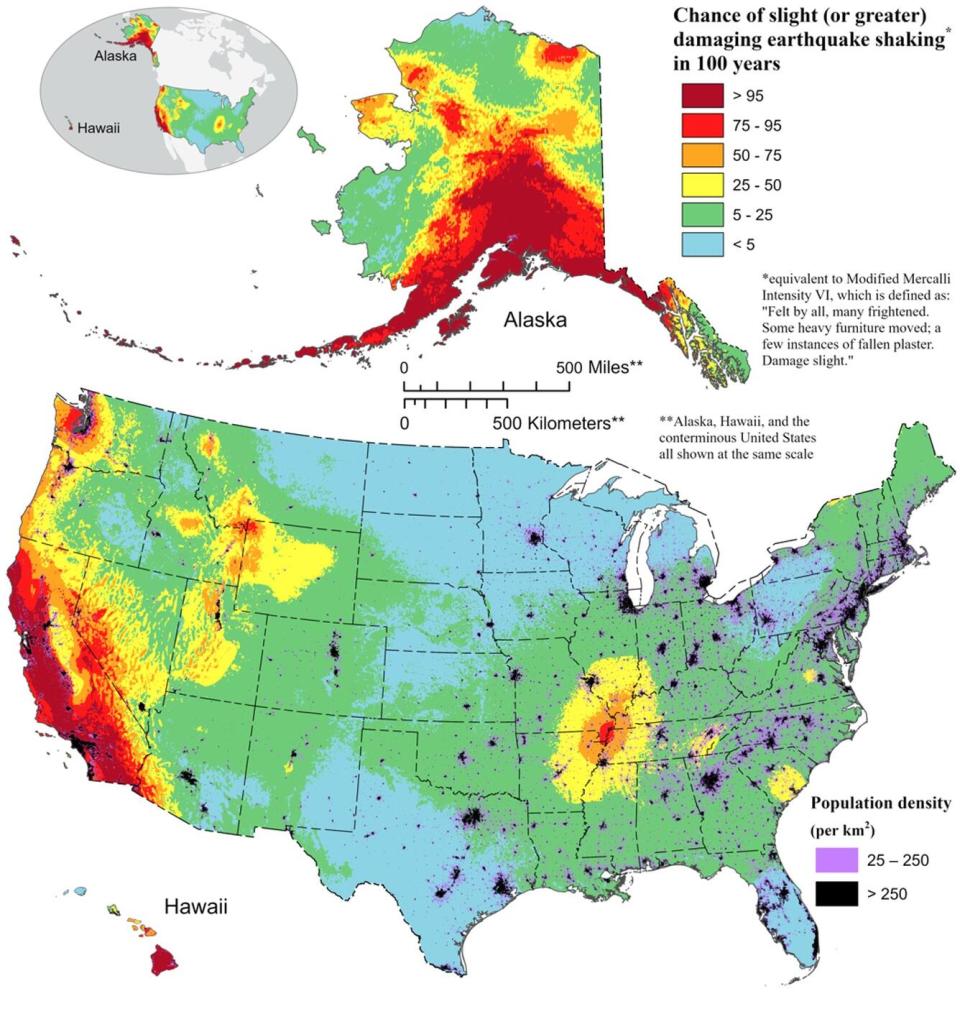
Nearly 75% of the US is at risk from damaging earthquakes, new map reveals

Nearly 75% of the U.S. could be struck by damaging earthquakes, the U.S. Geological Survey (USGS) has discovered.
The new finding, made by a model used to build a color-coded earthquake map, reveals that millions of Americans live in areas with a high earthquake risk. That includes known earthquake hazard zones such as Los Angeles, San Francisco, Portland and Seattle but also locations like Salt Lake City and Memphis.
According to the new model, 37 U.S. states have experienced earthquakes greater than magnitude 5 in the last 200 years.
The new information helps to update the odds of harmful quakes in the seismically active regions of Alaska and California and highlights the possibility of more damaging earthquakes along the central and northeastern Atlantic coastal corridor, which includes the cities of Washington D.C., Philadelphia, New York and Boston. The researchers published their findings Dec. 29 in the journal Earthquake Spectra.

"Earthquakes are difficult to forecast but we've made great strides with this new model," lead author Mark Petersen, a geophysicist at the USGS, said in a statement. "The update includes more faults, better-characterized land surfaces, and computational advancements in modeling that provide the most detailed view ever of the earthquake risks we face."
Earthquakes occur because tectonic plates get locked together as they move over the mantle. The forces that caused them to collide continue to build up until the plates suddenly shift . This creates a gigantic rupture, releasing energy in the form of potentially devastating seismic waves that violently shake the ground.
RELATED STORIES
—Balanced boulders on San Andreas fault suggest the 'Big One' won't be as destructive as once thought
—Aftershocks from devastating 1886 Charleston earthquake may still be hitting the US today
—Deadly swarm of earthquakes in Japan caused by magma moving through extinct volcano
Scientists have searched for patterns that could forecast major earthquakes for decades, but without a precise map of Earth's subterranean crust, these efforts have come up short. Instead, geophysicists collate data on past earthquakes' locations and magnitudes to create risk maps indicating where the strongest and most frequent temblors could hit.
The new map is the first National Seismic Hazard Model to chart this risk across all 50 states, and is the result of a collaborative effort between federal, state and local officials.
Notably in the new model, the strength of the quakes in Hawaii have been upgraded — the consequence of increased volcanic activity witnessed in recent years in the region.
"This was a massive, multi-year collaborative effort between federal, state and local governments and the private sector," Petersen said. "The new seismic hazard model represents a touchstone achievement for enhancing public safety."

