National Trails Day is June 1. Celebrate the outdoors on one of these 7 Springfield trails
Correction: An earlier version of this story misnamed the Frisco Highline Trail and Ozark Greenways. It also included incorrect or outdated information about the features of the Frisco Highline Trail, Wilson's Creek and James River greenways and the African-American Heritage Trail. The story has been updated.
Lace up the hiking boots and grab the sunscreen because National Trails Day is less than two weeks away.
National Trails Day, hosted by the American Hiking Society, is Saturday, June 1. Deemed the country's largest celebration of trails, the holiday is designed to promote trail maintenance and usage throughout the U.S.
You don't need to leave city limits to enjoy great trails around Springfield. Check out a list of seven trails compiled by the News-Leader. This is not a comprehensive list of trails around Springfield.
Frisco Highline Trail
Where to start: Springfield Trailhead at 3845 W. Kearney St.
Length: 35 miles
The Frisco Highline Trail is a 35-mile trail that connects Springfield and Bolivar, weaving through the Ozarks. Originally, this 35-mile stretch was occupied by the St. Louis-San Francisco Railway Co. The trail includes both paved and gravel sections.
Don't feel intimated by the 35-mile length, there are plenty of different entry points and attractions along the Frisco Highline Trail anyone can stop in at. Notable points of interest include the History of Willard's 1908 Bank Robbery Kiosk (mile 6), 7C's Winery in Walnut Grove (off mile 18) and a series of former railroad bridges from mile markers 17 through 35. For a full list of attractions along the Frisco Highline Trail, visit the Ozark Greenways website.
Wilson's Creek Greenway
Where to start: Tal's Trailhead at 3351 S. Kauffman Road
Length: 5 miles
Located in southwest Springfield, the Wilson's Creek Greenway travels through Rutledge-Wilson Farm Park. It connects to Jordan Creek Greenway at Ewing Park, and to South Creek Greenway east of Tal’s Trailhead, granting access to other points of interest on those trails such as Cruse Dog Park and Nathanael Greene/Close Park, respectively.
The Wilson's Creek Greenway is intended for walkers, runner, bicyclists and in-line skaters. The trail is wheelchair and stroller accessible. The trail features a combination of mixed asphalt and paved surfaces with minimal inclines.
In addition to Tal's Trailhead, parking is available at the Volunteer Nature Trail section, Rutledge-Wilson Farm park and Ewing Park Sports Complex.
Galloway Creek Greenway
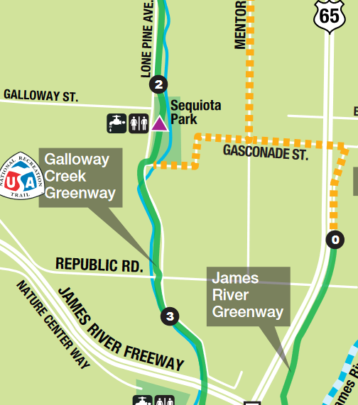
Where to start: Pershing Middle School at 2713 E. Seminole St.
Length: 5 miles
The first trail in Missouri to be designated as a National Recreation Trail in 2003, the Galloway Creek Greenway runs north to south in southwest Springfield. The trail features a combination of asphalt and concrete surfaces with moderate inclines.
In addition to Pershing Middle School, parking is available at The Towers Shopping Center, Sequiota Park, Springfield Conservation Nature Center and James River Iron Bridge.
James River Greenway & Trail of Honor
Where to start: Southwood Boat Access & Trailhead at 5201 S. Southwood Road
Length: 3 miles
The James River Greenway is split up into three one-mile segments: James River Iron Bridge Bridge north to the former frontage road east of U.S. 65 (Gasconade Avenue), the north bank of Lake Springfield Park and the Trail of Honor, which is located along the banks of James River up to the Missouri Veterans Cemetery. The greenway is a mix of concrete and asphalt with minimal to moderate inclines.
In addition to the Southwood Boat Access & Trailhead, parking is available at Lake Springfield Park.
Springfield-Greene County African-American Heritage Trail
Where to start: Timmons Hall at 1055 E. Webster St.
Though it is not a traditional outdoor hiking trail, the Springfield-Greene County African-American Heritage Trail provides a great way for residents and visitors to learn about the history of Springfield's Black community.
Winding through the city, the trail is planned to feature 20 sites of interest — markers have been installed at a portion of them — including the Commercial Street Business District, Sherman Avenue Corridor, Silver Springs park, Lincoln Memorial Cemetery, Jones Alley Business District, Alberta's Hotel, Bartley-Decatur Neighborhood Center, Park Central Square, Kentwood Arms Hotel, Washington Avenue Baptist Church, Benton Avenue AME Church, Pitts Chapel Methodist Church, Gibson Chapel Presbyterian Church, Graham's Rib Station, St. Louis Street, former Lincoln School and Springfield Art Museum.
Fassnight Creek Greenway
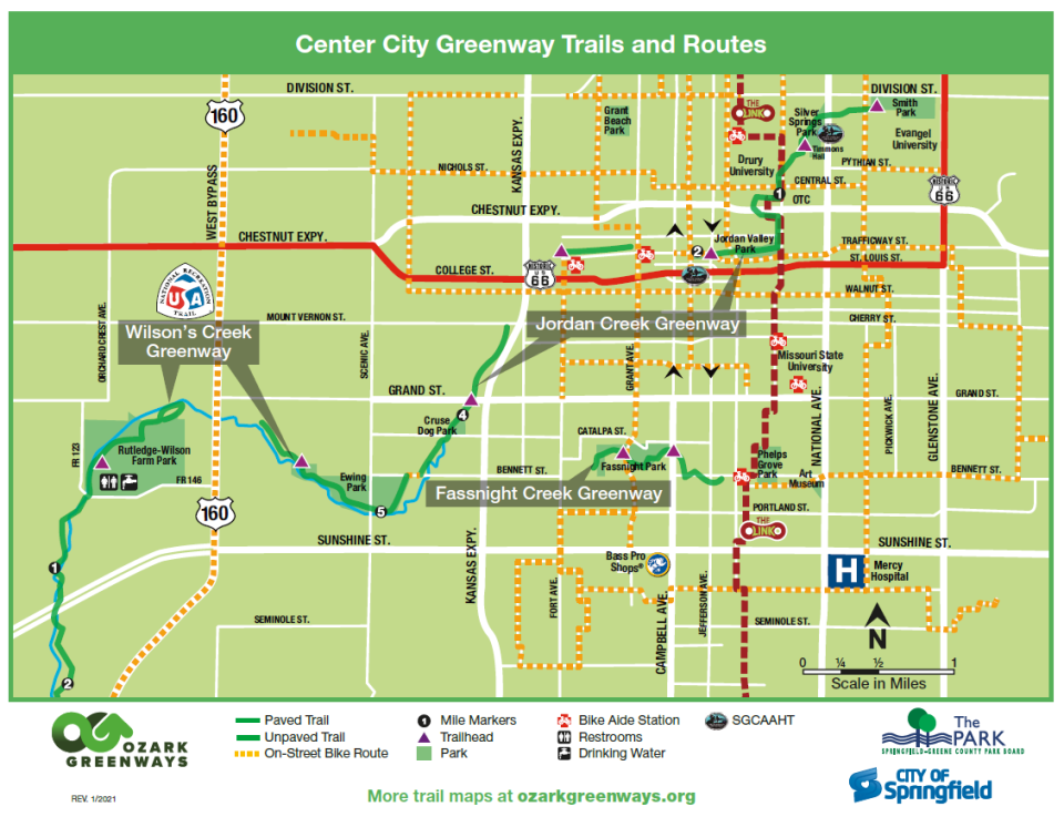
Where to start: Fassnight Park at 1301 S. Campbell Ave.
Length: 1.2 miles
Located in the heart of Springfield, the Fassnight Creek Greenway passes through Fassnight Park and Phelps Grove Park and runs under Campbell Avenue, Bennett Street and Jefferson Avenue. All of the greenway is paved, ideal for walkers, runners, bicyclists and in-line skaters.
Sac River Mountain Bike Trails
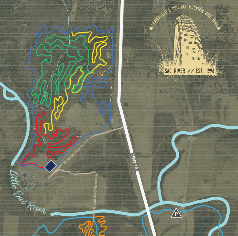
Where to start: Sac River Mountain Bike Trails Trailhead located three miles north of Interstate 44 off Highway 13
Length: 14 interconnecting miles
If you're interested in a longer, more remote trail, the Sac River Mountain Bike Trails on the northwest side of Springfield may be perfect for you. The trail, which features 14 interconnecting miles, is best suited for mountain bike riders of any skill level, trail runners and hikers. The trail's terrain is a single dirt track. It is rocky in some places.
The Sac River Mountain Bike Trails weave near Little Sac River, a small picnic pavilion, two historic cemeteries and Ritter Springs park.
If you're interested in learning about more trails located around Springfield, visit the Ozark Greenways website and Springfield Missouri Convention & Visitors Bureau website. Hiking platforms like All Trails, Gaia GPS and TrailLink also provide clear information about nearby trails and parks.
Travel outside of Springfield for these 3 American Hiking Society events
In addition to self-exploration, the American Hiking Society is hosting countless events throughout the country for National Trails Day, including three in Missouri.
Salem (2 hours from Springfield)
The Missouri Chapter Trail of Tears Association and The Dent County Historical Society is hosting a two-mile hike on the old Mark Twain National Forest Trail Path on June 1 from 9 a.m. to noon in Salem. The hike will begin on Reynolds County Road 903 where the National Park Service Trail of Tears National Historical Trail Original Route Sign is located. Parking is free and long pants, a hat and boots are recommended.
Also in Salem, the Ozark Trail Association is hosting a trail maintenance event along the upper current of the Ozark Trail on June 1 from 9 a.m. to 5 p.m. Folks should meet at the Current River State Park to learn more about the trail and how they can help preserve it. After cleanup, a dinner will be served for all participants and a raffle will be held.
Brownfield (1 hour from Springfield)
The Back Country Horsemen of Missouri Brownfield chapter is hosting a hike, cycle and horseback ride day at Cole Creek Trail in Brownfield on June 1 from 9 a.m. to 5 p.m. The come-and-go event will feature a five-mile walking hike, eight-mile bicycle trail and 10-mile horseback trail.
Organizations are still able to register their own official National Trails Day events on the American Hiking Society website at americanhiking.org/national-trails-day/host-information/.
Enter the National Trails Day photo contest to win a $1,500 prize package
To promote the holiday, the American Hiking Society is hosting a photo contest for National Trails Day with a prize package worth $1,500.
To enter, folks should share photos or videos on Instagram, tagging @AmericanHiking and using the hashtag #NationalTrailsDay. The photo contest opens June 1 and closes June 8.
The prize package includes LEKI trekking poles, LOWA hiking boots/shoes, Fjällräven Vidda Pro or Keb Trousers, Wild Tribute Smokey Vintage Bear t-shirt and Smokey Vintage Bear hat, six-pack of Athletic Brewing Co. non-alcoholic beer and pint glass, Osprey Downburst Pack, Mile Marker greeting cards, Brunton Navigator Bundle, $100 XERO Shoes gift card, Your True Nature Advice from the Trail card set, Backpacker's Pantry New Meal Bundle with a long-handled spoon and backpacker mug, Hydrapak Contour 21 Reservoir and assorted American Hiking Society stickers. For more information about the prize package, visit the American Hiking Society website. Four prize packages will be available to win.
Greta Cross is the trending topics reporter for the Springfield News-Leader. She has more than five years of journalism experience covering everything from Ozarks history to Springfield’s LGBTQIA+ community. Follow her on X and Instagram @gretacrossphoto. Story idea? Email her at gcross@news-leader.com.
This article originally appeared on Springfield News-Leader: 7 trails worth exploring around Springfield for National Trails Day

