This Interactive Map Will Tell You Exactly Where and When to See This Weekend's Solar Eclipse
Find the best viewing spots and the exact times that the rare celestial event will take place in each location.
Courtesy of The Planetary Society
One of the rarest kinds of solar eclipses — the annular eclipse, also known as a “Ring of Fire” — will make its way across the Americas on Saturday creating a spectacle for those in its pathway.
Those looking for the perfect time and place to see the eclipse are in luck as The Planetary Society, a non-profit space organization whose current CEO is Bill Nye, has come up with a Total Solar Eclipse Map to find the best viewing locations and provide exactly what time the occurrence will happen there.
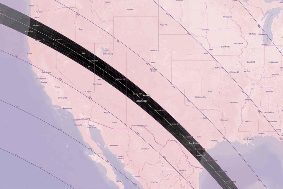
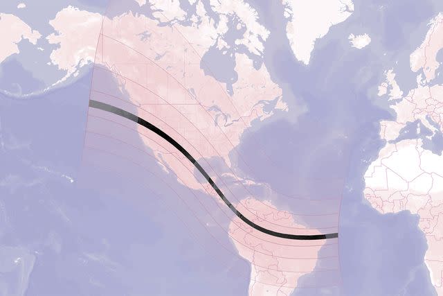
The map opens up to a view of North and South America, with the ribbon across the annualarity region (the areas that will witness the complete coverage of the moon across the sun), crossing from Oregon through northern Brazil.
Courtesy of The Planetary Society
Click on the major cities in those regions, and the map will reveal the time of the annualarity (down to the second), how long it will last, the average cloud cover, and the sun altitude. Additionally, there’s a drop down menu that will reveal what kind of phenomenon will be viewable at that particular spot.
For instance, Eugene, Oregon, will be in annularity from 9:16:57 a.m. to 9:20:52 a.m. local time for a duration of three minutes and 55 seconds. There will be average cloud coverage of about 45 percent during the time and the sun’s altitude will be at 18 degrees. Partially-covered sun, crescent shadows, sharper shadows, color changes, the ring of fire, diamond ring, and Bailey’s Beads — the beads of sunlight that shine from behind the moon during a solar eclipse — will also be visible at this time.
Over in Corpus Christi, Texas, the same seven phenomenon will be viewable with annualarity happening for five minutes and two seconds from 11:55:30 a.m. to 12:00:52 p.m. with an average 50 percent cloud cover and 49 degree sun altitude.
For select destinations, the map even goes as far as having a link to hotels in the area with availability on Booking.com. (Yes, there are still rooms available in Eugene and Corpus Christi!)
Locations outside of the band can also find out how much of the partial eclipse they can see. For instance, the map shows that New Yorkers are 1,537 miles from annualarity, but will be able to see the sun partially covered from 12:07 p.m. to 2:36 p.m, and those in Los Angeles are 379 miles from the annualarity pathway, but can see the partially-covered sun from 8:07 a.m. to 10:50 a.m., as well as crescent shadows and sharpers shadows.
The Planetary Society’s Eclipse site also provides a map for next spring’s total solar eclipse on April 8, 2024, as well as vocabulary lists, viewing expectations, and safety tips of how to best experience the rare event. And for The Planetary Society superfans, they even sell a limited edition Bill Nye Eclipse Glasses, with their famous CEO’s face on it.
For more Travel & Leisure news, make sure to sign up for our newsletter!
Read the original article on Travel & Leisure.

