Hurricane Florence Officially A Category 4 As It Continues To Gain Strength
UPDATE: Sept 11, 2018: With winds hitting up to 130 mph, Hurricane Florence has officially been upgraded to a Category 4. It is currently moving west-northwest at a pace of 15 mph as it heads for its predicted landfall in North Carolina.
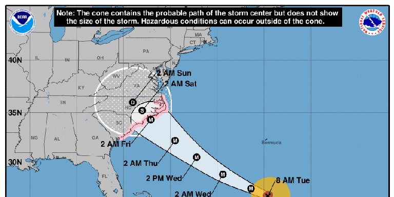
The National Hurricane Center (NHC), whose predictions about Florence have been accurate so far, now says that the storm will build in size, strength, and speed before it reaches land on Friday.
Hurricane #Florence has weakened slightly but is expected to restrengthen later today. This morning view from #GOESEast shows the powerful storm about 1,000 miles east-southeast of Cape Fear, N.C. Latest: https://t.co/LdMJC4oIds pic.twitter.com/sIRmw8vVQp
- NOAA Satellites (@NOAASatellites) September 11, 2018
Florence currently sits around 1,000 miles from Cape Fear, North Carolina. But the Tar Heel State isn't alone in facing danger. The entire Mid-Atlantic region from South Carolina to Washington, D.C will likely be affected by Florence. The NHC has issued a storm surge warning from Edisto Beach, South Carolina to the North Carolina-Virginia border. A storm surge warning indicates that there will be a possibility of life-threatening conditions from rising waters.
“Florence is expected to remain an extremely dangerous hurricane when it approaches the U.S. coastline,” says National Hurricane Center specialist Daniel Brown, speaking to South Carolina's Post and Courier. “The hurricane is predicted to meander over the eastern portions of North or South Carolina (Friday and Saturday),”
At its peak scientists say that Florence should hit 150 mph, bringing it just 7 mph of being classified as a Category 5 hurricane.
Hurricane #Florence is not just a threat to the coast. Very heavy, prolonged rainfall is expected over a large portion of the Carolinas and mid-Atlantic. Here is the latest 7 day rainfall forecast from @NWSWPC. pic.twitter.com/HVMCOMDQIr
- National Hurricane Center (@NHC_Atlantic) September 10, 2018
Florence's temporary weakening this morning can be attributed to a phenomena known as eye wall replacement. Eye wall replacement is a regular and violent occurrence amidst intense storms, when "a new eye wall or ring of thunderstorms within the outer rain bands forms further out from the storm’s center, outside of the original eye wall," according to NASA. This new ring of thunderstorms starves the original eye of momentum and moisture. The eye wall begins to collapse, temporarily weakening the storm.
If given the chance to complete the cycle, the new ring of thunderstorms will eventually take main stage as the new eye wall. With the new, stronger eye wall in place, the hurricane continues to gain strength.
A prime source of Florence's gaining power have been sea surface temperatures in the western North Atlantic, which according to NOAA have been "running significantly above normal" for the last several weeks. Scientists attribute these warming waters to climate change.
Monday, September 10: The National Hurricane Center (NHC) is now forecasting that Florence will hit North Carolina, South Carolina and Virginia as a Category 4 by early Friday morning. The three states have declared a preemptive state of emergency.
OK you guys, my intention is not to scare anyone with this message.
But Hurricane #Florence-the storm bound for North Carolina-is going to be about the size of North Carolina when it arrives.
This is what it will look like, according to the latest high-res model prediction: pic.twitter.com/B8vCm3FDi6- Eric Holthaus (@EricHolthaus) September 10, 2018
Hurricane Florence is forecast to become a major hurricane today; residents in the Southeast and Mid-Atlantic should closely monitor Florence https://t.co/3mqezNysQA
- NWS WPC (@NWSWPC) September 10, 2018
Using infrared satellite data, NASA detected the growing eye of Hurricane Florence yesterday. At that time, Florence was around 610 miles (985 km) miles northeast of the Northern Leeward Islands in the Caribbean. The hurricane's swells are expected to hit Bermuda especially hard.
Florence is currently a Category 2 hurricane, but meteorologists at the NHC are predicting the storm will spend Monday gathering great strength. "There is an increasing risk of life-threatening impacts from Florence," the NHC said in a statement early Monday morning. The NHC suggesting these impacts could stem from a "storm surge at the coast, freshwater flooding from a prolonged and exceptionally heavy rainfall event inland, and damaging hurricane-force winds."
The NHC also stressed that, with a predicted landfall early on September 14, "it is too soon to determine the exact timing, location, and magnitude of these impacts." But it's never too soon to start planning in the event of a hurricane. For those living in areas that will likely be affected by Florence, now is a perfect time to run through hurricane checklists.
If and only if everything is tied down and preparations are set, there's always the option of throwing a hurricane party.
But think carefully before busting out the red solo cups. For a reference point on the power of a Category 4, that was the measured strength of last year's Hurricane Harvey. Both Florence and Harvey have gained speed using the same underlying principle: hotspots and updrafts meeting in the ocean. Observed hurricane activity over the last several decades has shown that the storms are gaining more intensity in concert with global warming.
You can follow the National Hurricane Center's tracking of Florence here.
Source: National Hurricane Center
('You Might Also Like',)

