I Hiked Across the Ozarks Looking for Adventure—and Got More Than I Bargained For
This article originally appeared on Backpacker
It was the middle of a long Montana winter, and I needed an escape. The landscape was a canvas of snow-covered peaks, beautiful yet isolating, and the relentlessly short, cold days gnawed at my morale. So I started looking south.
In late 2020 I had thru-hiked the Ouachita Trail, and enjoyed the rolling hills, pristine shelters, and deciduous forests. Throughout that trip, hikers and trail angels kpet recommending the Ozark Highlands Trail, a route in the Arkansas mountains. The OHT is more rugged and mountainous, with more waterfalls, lakes, and rivers along the way. It's also a lot more remote: It avoids most towns and roads along its 250-mile routes, which makes resupplying a challenge. Compared to the Ouachita, it would be less forgiving, and a lot tougher to escape if weather rolled in. It sounded perfect. With a two-week window to finish the trip, I thought I might even be able to do it twice, going for an FKT on the return leg. I booked my ticket.
I flew into Fort Smith, Arkansas, and caught a ride from a good friend and incredible hiker, Lo Phong La Kiatoukaysy, aka Lil' Buddha, who drove us to the terminus at Lake Fort Smith to begin the thru-hike. We had last backpacked together in the Sierra when I was a 20-year-old with an external-frame pack and Buddha was out finding himself on the long-distance trails of America. While our lives had run parallel since then--we both built our careers around our passion for foot travel on trails--we hadn't shared miles in too long.
It may have been winter, but as we hiked around Lake Fort Smith, it felt like spring. Birds were chirping, and armadillos scampered across the trail. The path meandered around the shores of the lake, crossing small streams that spilled into the lake at each inlet. We had eleven years to catch up on, and by the time we finished, we had covered the first 30 miles of the trail. Buddha was as strong a hiker as I remembered: Unlike with other partners, I never had to worry whether he could break camp fast enough or keep pace with me. The trail was peaceful, too. Every night we had a vibrant sunset, soft ground to sleep on, and a nearby stream to have an icy soak in. Before the sun rose every morning, we were back on the trail and heading east.
After two days with a partner and help with a resupply, I was on my own for the rest of the trail. Shortly after Buddha left, things took a turn for the tougher. A brutal, freezing rain began to fall, and soon morphed into snow. The temperature plummeted, putting my three-season gear to the test. For the next two days, I wore every layer I had packed.
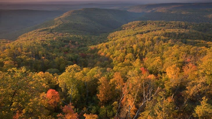
The weather kept getting worse. The temperature dropped into the 20s, and winter storm warnings pinged my phone. The streams swelled until they spilled their banks. The trail's sunny start faded into a distant memory. And then, I arrived at Hurricane Creek.
Among the many stream crossings on the Ozark Highlands Trail, Hurricane Creek stands out. Despite the name, it is the size of a river and swells quickly with the weather. The water is swift, and the banks are steep and overgrown. Every inch of the creek is different: At one bend, large boulders may be stacked up haphazardly all the way across the water, and around another, the current may have cut a deep channel into the soil. It is remote, with few alternates or suitable fords. When I arrived, it was near its peak flow and icy cold.
At the first crossing, I found a series of boulders a foot below the raging current and tiptoed my way across. But at the second crossing, there were no rocks. The banks were near vertical and mostly made of soft mud. I slowly side-hilled my way upstream a couple hundred yards, but it took 30 minutes, and I knew I would need to cross it. The water was muddy and nearly 30 feet across; I couldn't tell how deep it was, so I prepared for the worst. With no way around it, I packed everything in watertight bags and waded into the water.
With the first step, I sank up to my waist; the second, up to my chest. I quickly realized I would have to swim. One deep breath, and I sprawled out into the water. It was deceptively fast. Buoyed by my pack, I slowly doggy-paddled, aiming slightly upstream and letting the current correct me. The cold was shocking, but with adrenaline kicking in, I barely felt it. I made slow and deliberate progress, focusing on holding my head up and rhythmically stroking my arms through the muddy water. When my feet finally touched the bottom, I gasped. It was eerily similar to swimming the Kennebec River on the Appalachian Trail--an unwise act I had hoped never to repeat. Once again, I had neglected to plan for changing weather and the impact of torrential rain on water sources, and my thru-hike had included a swim.
Now, I had another problem: I was wet, and the temperature had dropped into the 20s. I quickly started hiking east, hoping exertion would warm my body. Water continued to cascade down the rocks, and then the rain turned to snow. My situation was beginning to feel dangerous. A hotel and a break after the events of the day were much more appealing than huddling for warmth in a damp tent and sleeping bag. I hiked to Highway 7 and thumbed a ride into Clarksville.
A couple with a long history in the area picked me up and spent the ride filling me in on the viewpoints, farms, and the Rotary Club's work maintaining trailheads and outdoor recreation through the remote mountain range. I soaked it in. I had missed this kind of history on the 18-inch-wide footpath. What the remote route offered in nature and ruggedness, it lost in its connection to the communities it passed.
If my ride was an introduction to local culture, I got a full immersion once we arrived in Clarksville. Only one restaurant was open, and it happened to be a dingy-looking buffet. But at $8, I was in. I stuffed myself with crawfish, questionable sushi, barbeque, and pasta. It was a return to my roots: Eat until you can barely walk, and then waddle back to the hotel.
The next day, I returned to the storm. The trail was a muddy mess. It was cold, with few breaks in the downpour. I thought back to my original plan to thru-hike the trail in one direction and then try for an FKT on the return trip. Now, trudging through the rain, the plan seemed foolish. No one sets a record time on a trail that involves swimming. Knowing it wasn't going to happen actually eased my mind: Now, I had the luxury of slowing down and enjoying the views.
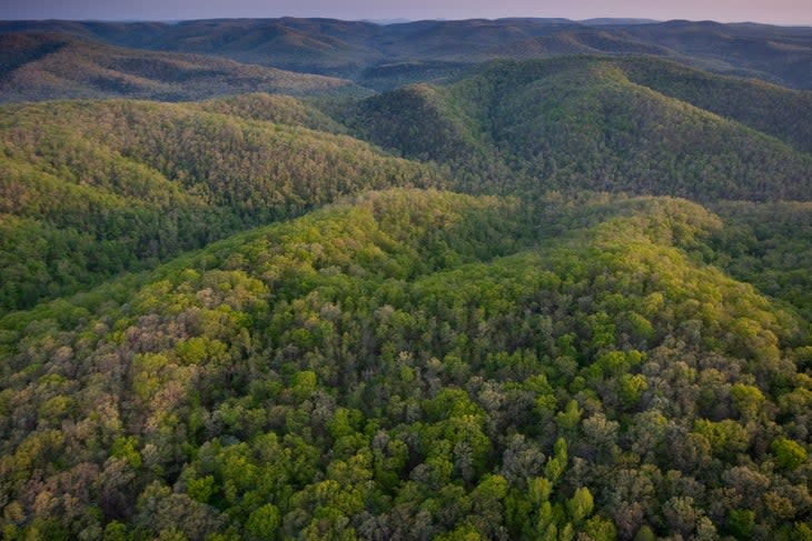
The weather had improved overnight. The sky was dotted with fluffy clouds and patches of sunshine. The rolling, forested hills disappeared into the distance, and the trail began to climb more steeply up the mountains. Without the pressure to finish quickly, I felt oddly comfortable on the rough path. Best of all, I had it all to myself.
My next obstacle was the Buffalo River, where the trail's current path ended. I had originally planned on turning around there, but with no FKT in my future, I decided to continue onward along the OHT's proposed route to Matney Knob. First, I had to cross the Buffalo, and there was no way I was swimming this one. I sat on the swollen river's banks, listening to elk bugle in the meadow nearby. The water was swift and thick with mud, carried down by the rain as it flowed off the surrounding hills.
Within an hour, a boat launched from the campground on the other side, and I flagged them down. After I explained that, yes, I truly did intend to keep hiking off into the wilderness, they were kind enough to shuttle me over, and I was back on my way.
It was obvious few hikers had ventured beyond the Buffalo: Over and over again, the trail climbed straight up to the top of a 300-foot rock wall overlooking the river, and then suddenly dropped back down to its banks. Branches and thorns hung across the trail, grabbing at my clothing and cutting up my legs. Sometime after reaching Grinders Ferry, my trail disappeared entirely, and I found myself bushwhacking. Blackberry thorns had long overgrown any potential pathway; the route followed the side of a muddy hill, and casual glimpses of the river were my only assurance that I was on track. I climbed up car-size rocks, down fallen trees, and crawled through brambles to connect back to a more maintained trail 15 miles further on. But it seemed pointless. This section of the trail had seen little love (if any), and I needed to change my plan.
I camped for the night and looked at my maps before falling asleep. Gravel roads crisscrossed the area, and they would be my best chance at completing this entire route on foot. I found one road that I could hike to a more popular trail, which I could then follow east. Another storm was coming in, and this time; the forecast was for rain, ice, and a layer of snow on top. My goal changed again: I decided to push hard in hopes of wrapping up the adventure before the snow arrived.
Regaining the trail the next morning was a treat. The terrain was completely different: The woods were old and eerie, with hundred-foot trees and very sparse undergrowth. I hiked through the mist all day. As night came, however, thunder clashed in the distance, and my tent nearly doubled over in the wind. By 4 a.m., the floor of my shelter was a puddle, and the storm showed no sign of letting up. So, I packed up to begin my last 18 miles: My desire to be comfortable had finally surpassed my hunger for adventure. With the early start, I figured my soaked gear and I could hit the finish line by mid-afternoon.
After seven more hours of trudging through the swampy forest and across more creeks and ledges, I finally arrived at Matney Knob Trailhead, the end of my thru-hike. My adventure on the OHT hadn't been what I expected, but it was every bit as invigorating as I had hoped. As the falling flakes built into a snowstorm, I stuck out my thumb and hitched a ride, bound for Fort Smith and then back to snowy Montana for the winter.
The Ozark Highlands Trail: Tips from a Thru-Hiker
Mentally prepare for wet feet: Waterfalls and streams are everywhere and keeping your feet dry is impossible in many of the sections. Pick a quick-draining, easy-draining pair of shoes.
Map out all possible resupply points: Even if you intend to do long carries, having a list of the possible early bailouts and resupplies will make any plan changes much easier. The trail is rugged and remote, which makes the miles slow and tough.
Prepare for quickly changing weather: The trail lacks the exposure of many alpine and high-altitude trails, but the weather can change just as fast.
Both termini are hard to reach from an airport: Set up a ride or have a plan for the start and conclusion of the hike.
For exclusive access to all of our fitness, gear, adventure, and travel stories, plus discounts on trips, events, and gear, sign up for Outside+ today.

