Hike to Yosemite’s Taft Point
This article originally appeared on My Yosemite Park
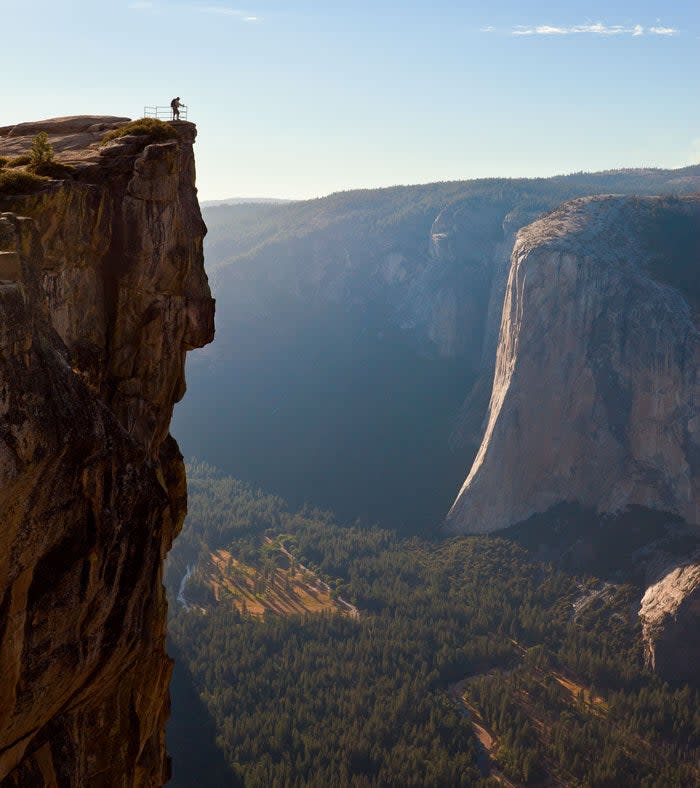
If you've seen photos of Yosemite on Instagram, you've likely seen a heart-stopping shot of far-away people on a precarious-looking drop-off above Yosemite Valley. This is Taft Point. Located just down the road from the famous Glacier Point, Taft offers similar views without the guard rails. A popular destination for elopements, those looking to get an incredible photo or just hikers who want great views, Taft Point is a short and easy trail with a big payoff.
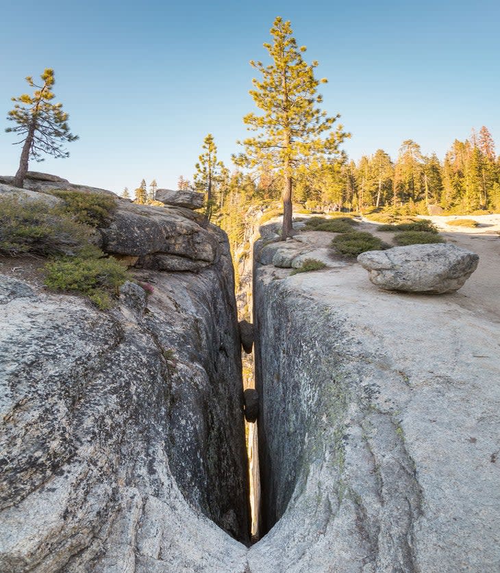
Along the way you'll hike through a picturesque forest and see interesting fissures in the granite that plunge far below your feet.
How Long is the Taft Point Hike?
The hike to Taft Point is 2.2-miles roundtrip. From the Taft Point Trailhead on Glacier Point Road, follow the signs for Taft Point, heading left.
The trail begins in the forest, following a wide dirt path across Sentinel Creek. You'll quickly reach a junction marked with a sign. Stay straight, following the directions to Taft Point. Parts of the trail can get quite muddy, so it's a good idea to wear hiking boots rather than tennis shoes to keep your feet clean and dry.
When you emerge from the forest, the trail will start to head downhill. On the right side of the trail, you'll see large fissures in the cliff, plummeting down long distances.
There are several overlooks at Taft Point. The first has a small fence on top and is the best viewpoint if heights make you nervous. Take in the astounding views of Yosemite Valley, including Yosemite Falls.
From here, you can either head back the way you came, or continue on to the next overlook. If you want the classic shot of you standing on the point over the abyss, leave someone in your group at the fence to take the photo.
There's a smaller trail that leads to the obvious point to your left. Head towards the big boulders. Just past them is the guardrail-less point. The views here are stunning. You'll see El Capitan and the rest of Yosemite Valley in the distance. While the point is larger and flatter than it looks in photos, the sheer drop below is 3,000 feet. People have died falling here. Be extremely careful of your footing and stay away from the edge. Keep small children close to you and don't venture out onto the point if there are strong winds.
If you're looking for a longer hike, add in Taft Point to a hike to Sentinel Dome, making a 5-mile loop. Both hikes start at the same trailhead and can be connected via the Sentinel Dome and Pohono Trail, but it's easier to go counterclockwise and start with Sentinel Dome.
How Hard is the Taft Point Hike?
The hike to Taft Point is fairly easy. It only gains approximately 200 feet in elevation, and all of that is on the way back as the point is lower than the parking lot. While the distance and lack of elevation gain make this hike on the easy side, it's not a good choice for families with small children as the steep drop-offs without guardrails are every parent's nightmare.
Taft Point sits much higher than Yosemite Valley at 7,500 feet in elevation. Those who live at sea level may find the hike more challenging due to the altitude. Make sure to bring and drink plenty of water to stay hydrated and fight the effects of any altitude-related symptoms like headaches or nausea.

Can I Drive to Taft Point?
You cannot drive to Taft Point. To get this iconic view, you'll have to hike 2.2-miles roundtrip from the trailhead. To get there, drive Glacier Point Road approximately 6 miles from its beginning at Wawona Road. The trailhead is on the left. If you reach Glacier Point, you've gone too far.
If you're looking for a similar view that doesn't require a hike, keep going to the end of the road where you'll find Glacier Point. A short walk will bring you to stunning views of Half Dome and the rest of Yosemite Valley, plus ample guardrails and benches make it a great choice for families with small children to take in the views more safely than Taft Point.
In 2022, Glacier Point Road is closed for construction. Part of the improvement projects will be increasing parking at the Taft Point Trailhead, which will be a welcome respite from the current crowding in the tiny lot. The only way to access the road in 2022 will be by hiking one of three long and strenuous trails up (and back down) from Yosemite Valley. It's probably a good idea to save Taft Point for 2023 when you can drive to the trailhead, although thirty-minute delays are possible spring through fall in 2023. Check for road conditions at www.nps.gov/yose/planyourvisit/conditions.htm.
For exclusive access to all of our fitness, gear, adventure, and travel stories, plus discounts on trips, events, and gear, sign up for Outside+ today.

