Hike Mauna Kea: The Expert Guide to Hiking Hawaii’s Highest Point
This article originally appeared on Backpacker
Hiking Hawaii's Highest Point
Jump Right to the Hike & Map | Important Information on Altitude Sickness
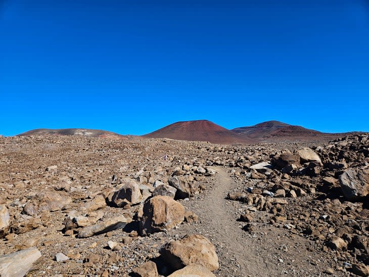
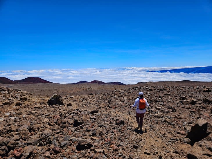
Hawaii's highest mountain is one of the most spectacular hikes on the planet, a place where the Arctic and the tropical meet. Mauna Kea's volcanic topography feels like a land before time, primal and raw. Pockets of plant life defiantly decorate the coarse, sandy soil on the lower slopes, giving way to barren stretches of chunky rock and ashy sand. It's not unusual for the terrain over 11,000 feet to be coated in a hyper-white layer of snow.
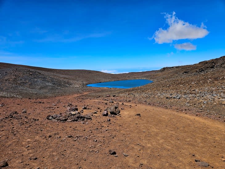
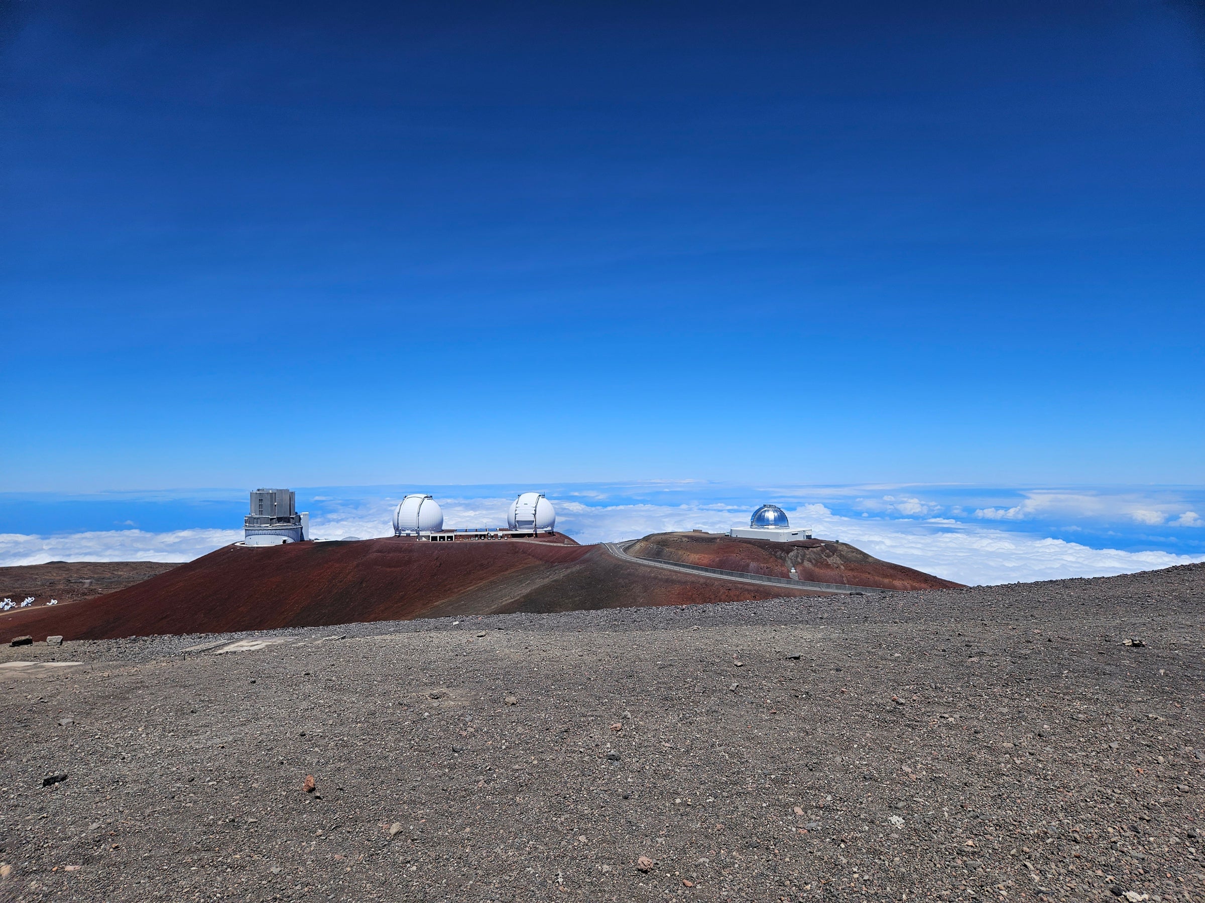
Lake Waiau is a surprising feature of Mauna Kea, a small but permanent lake at 13,020 feet. It's one of only two natural lakes on the Big Island of Hawaii (there are only five natural lakes in all of the Hawaiian islands). But perhaps the most fantastic sight is the collection of thirteen summit observatories atop the peak. High above the clouds on this sacred mountain, the future and the past merge.
The standard route to the summit, The Humu'ula Trail, is an excellent day hike--if you are adequately prepared. It's 13.2 miles round-trip, with a stiff 4,500 feet of elevation gain. On the plus side, it's not a technically difficult hike. The trail itself is a Class 1 walk-up. The last mile is along a paved road, though you won't begrudge it when you see the views it offers.
Backpacker's guide to Mauna Kea will share the knowledge and preparation needed to not only summit Hawaii's state point but to do so without feeling the withering effects of altitude.
Important Note on Mauna Kea's True Summit & Lake Waiau
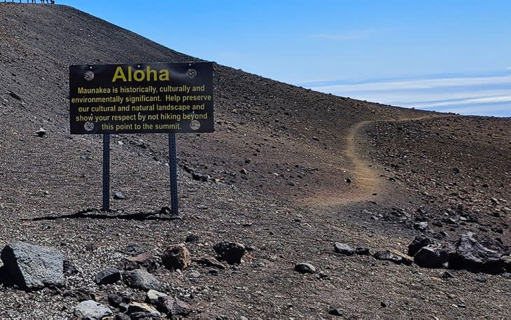
You can hike or drive to the summit area of Mauna Kea, but please do not visit the small hill that marks the mountain’s highest point. This area is sacred to Hawaiians--both ancient and modern. Rangers will remind you to refrain from walking over to this point when you check in at the visitor's center. This isn't a wink-wink-nudge-nudge recommendation; seriously, don't go there.
Likewise, the water that makes up tiny Lake Waiau is not to be touched. Don't throw rocks in, swim, or refill your water bottles. Just admire it from a distance.
Five Things to Know Before Hiking Mauna Kea
Mauna Kea's 13,804-foot summit means altitude will be a significant concern, especially for hikers who aren't prepared for it. This guide consulted Dr. Peter Hackett, a leading high-altitude expert, for advice on how best to hike Mauna Kea and feel good doing it. If preparation isn't possible, you can always drive a 4×4 vehicle to the summit or do a shortened hike starting from the 12,800-foot Lake Waiau Trailhead.
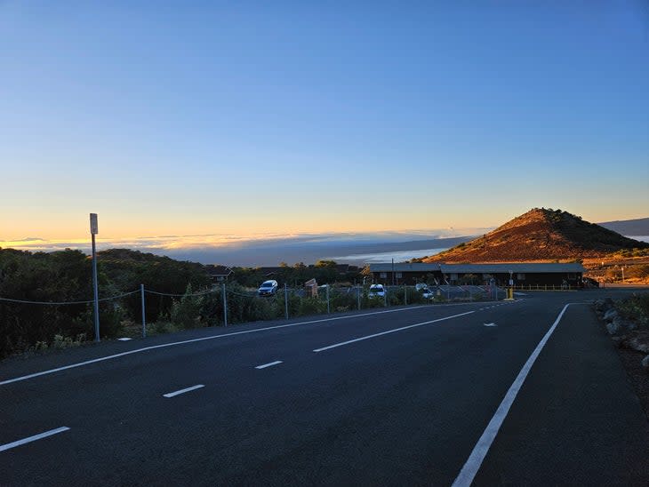
The Onizuka Visitor Center at 9,200 feet is your last chance to get water. There is no usable water on the mountain or in the buildings on the summit. The facilities are open only from 9 AM-9 PM. Since you should start your hike early, this means you need to get your water for the day with you before you drive up.
Be sure to bring sunblock and high-quality polarized sunglasses. The sun can be insidiously intense at high elevations.
An early start is highly recommended--6 a.m. or earlier. Unlike many other mountains in the continental US, this isn't to avoid storms. It's to beat the mid-afternoon heat and return before dark.
The Humu'ula Trail is occasionally closed for invasive species eradication or during bad weather (it does snow above 11,000 feet from time to time). Visit the visitor center page to check on trail conditions.
Quick Questions
How Long Does it Take to Hike Mauna Kea?
Rangers say to expect a 10-hour day for the entire hike. My time was 6 hours and 30 minutes, but I came from hiking 14,000-foot mountains in Colorado, so I was well-acclimated and in good hiking shape. Strong, acclimated hikers can expect around 7-9 hours. Less experienced or less acclimated hikers will be more like 8 – 11 hours.
Is Mauna Kea a hard hike?
If you prepare correctly, Mauna Kea is a moderate hike for fit hikers. It's long and steep but spread out over the 6.6-mile ascent along a Class 1 trail. There is no technical climbing or scrambling on the trail. That said, the altitude, distance, and cooler temps near the top can make for a challenging day for less fit or underprepared hikers.
Can you hike Mauna Kea without a tour? Does it cost anything to hike?
You do not need a guide or tour group to hike the Humu'ula Trail; it's free to explore. Likewise, there is no parking fee at the visitor center. Note that you do have to check in with a ranger at the start of your hike and check out at the visitor center when you are done.
How Tall is Mauna Kea?
Mauna Kea is 13,804 feet above sea level as measured by LiDar, the most accurate means of surveying height. Some maps have it at 13,796 or 13,803 feet, slightly off the LiDar measurement.
Is Mauna Kea still an active volcano?
It is! However, the chance of it erupting without warning is very low. If there is any danger, scientists will know well in advance, so don't let the idea of a spontaneous eruption deter your hike.
What gear do I need to bring for the hike?
I used day hikers for my feet--heavy boots are overkill for most people, as there is no technical terrain. You may want low gaiters to keep dust out of your boots on the lower, sandy part of the mountain. I highly suggest hiking poles, especially for the descent. Bring a light fleece jacket, a light shell for rain/wind, and a light puffer for the upper body.
It rarely gets below 30 degrees high on the mountain, but can be windy. Bring along a winter hat, gloves, sunglasses, and, of course, a backpack to carry it in. Don't forget water and snacks. Throw a headlamp in your pack just in case you're caught after dark. Finally, I did bring my inReach emergency locator device, though there is occasional cell reception on the mountain (and the rangers keep track of hikers as well).
Is there water along the way or at the top?
Nope. While Lake Waiau is high on the peak, its waters are sacred to the Hawaiian people and should not be touched. The summit facilities have no public water, though there are Portapotties.
How much water should I bring on the hike?
80-100 oz. (3 liters) per person. I suggest a 100oz. Camelbak or similar water-carrying system. The air is extremely dry and the hike at lower elevations can be hot.
Do people really ski on the mountain?
It's possible in rare circumstances, and it's a novelty, but it's not a regular thing. The mountain occasionally gets enough snow (usually in January or February) to "enjoy" a few hundred feet of turns on thin snow (over volcanic rock).
Is Mauna Kea part of Hawaii Volcanoes National Park?
No, it is outside of the boundary of the park. Mauna Kea is part of the Hawaiian crown lands, which are publicly accessible.
Strategies to Deal with Altitude Sickness
Advice for dealing with Mauna Kea's altitude found across the web can be misleading or, in some instances, downright wrong. Even some local Hawaiian printed guide literature is inaccurate.
I saw enough shaky advice online--such as waiting for a few hours in the parking lot to acclimate before your hike--that I consulted leading altitude expert Dr. Peter Hackett from the Institute for Altitude Medicine. Dr. Hackett is one of the world's leading authorities on altitude illness. Here's what he had to say.
"The healthy human body has an amazing capacity to tolerate the low oxygen air at high altitudes. On the summit of Mauna Kea, for example, at 13,800 ft, the oxygen in each breath is only 60% of what it is at sea level," says Dr. Hackett. "Despite that, most healthy folks can drive to the top and enjoy the views with only a bit of breathlessness and a mild headache as long as they don't stay longer than a couple of hours."
"Hiking to the top of Mauna Kea from the visitor's center at 9,200 ft on the day of leaving the beaches is an opportunity for suffering," continues Dr. Hackett. "The hike requires much more time and exertion than walking around a bit at the top after arriving by car. A period of acclimatization is necessary to do this comfortably. Spending a night or even two at 7,000 – 9,000 feet and then hiking to the top results in a safer and more comfortable experience. Sleeping at 7-9,000 feet somewhere for a night or two, or more, in the two weeks before going to Hawaii to hike Mona Kea is also helpful."
"The medication Diamox can speed up the acclimatization process and make the day more enjoyable. Ibuprofen can also help prevent headaches or can be taken at the first tinge of a headache. Spending an extra hour or two at the visitor's center is insufficient time for adjustment to the low oxygen and won't be of much help."
My personal experience is that Advil Liqugels (an Ibuprofen-based medicine) is best for staving off a low-level, manageable altitude headache. (As with any medication, consult with your doctor before trying a new over-the-counter med.)
Dr. Hackett adds, "Anyone considering the hike without prior acclimatization needs to take it slow, stay hydrated and nourished, and turn around if their body is telling them it is just too much."
The Difference Between Coming from High or Low Altitude
If you're lucky enough to come to Hawaii from a high home elevation (5,000 feet above sea level or higher), prioritize your Mauna Kea hike toward the start of your Hawaii adventure. Take advantage of all those thick, rich red blood cells flowing through your body. I came in from 7,200 feet at home and hiked Mauna Kea three days into my trip, and neither myself nor my wife felt anything from the altitude.
Should home be lower than 5,000 feet, Dr. Hackett’s Diamox option is a good option. It's a prescription, so you'll need to get it from your doctor before your trip.
Another good idea is to camp or sleep at a modestly high elevation, such at the 4,000-foot Volcano House or one of the campgrounds at Hawaii Volcanoes National Park. Besides being one of America's most amazing National Parks, two nights at this elevation can greatly help your body prepare for the big hike.
Camping is available at the Mauna Kea Recreation Area (also called the Gilbert Kahele Recreation Area) at roughly 6,400 feet.
Unfortunately, there is no public lodging at the visitor center, which is a shame because, at 9,200 feet, it would be a great place to spend a night or two before the hike.
Directions and Logistics
Parking
Driving to the Mauna Kea Visitor's Center is straightforward.
From Hilo the drive is about 45 minutes (35 miles). Google Maps Directions from Hilo.
From Kona it's roughly an hour and ten minutes (54 miles). Google Maps Directions from Kona.
Directions
Regardless of where you start, you'll take Saddle Road (HI 200) and turn north onto the marked Mauna Kea Access Road. Follow the road 6.2 miles to the Visitor's Center on your right. Rangers will have the road beyond the parking at the Visitor's Center blocked off. The general public can access the higher road only if they have a vehicle with 4×4.
For hikers of the Humu'ula Trail, a regular rental car without 4×4 is perfectly fine to reach the parking lot.
Note that it is actually illegal to sleep/camp in your car in Hawaii in public spaces and this includes the Visitor's Center.
Parking Coordinates for GPS: 19.760041176177154, -155.45443551514666
Fees
There are no fees to hike the Humu'ula Trail or to drive up the Mauna Kea access road beyond the Visitor's Center.
Registering to Hike
You must register to hike the Humu'ula Trail at the Visitor's Center. When you complete your hike, you must sign out on the form.
Visitor Center Hours
The Visitor Center is open 9AM – 9PM daily. Rangers are generally stationed at the road starting at 5AM and can assist you with your registration form--if they aren't there, go to the Visitor's Center's entrance and fill one out. There are portapotties at the lower parking area available 24 hours a day, but the main restrooms (and water supply) is only available when the center is open.
Visitor Center Information
808-934-4550
Mauna Kea Weather and Road Conditions
808-935-6268
Mauna Kea Visitor Center Website (https://hilo.hawaii.edu/maunakea/visitor-information/station)
Alternate Options to Get to the Summit
Before we dive into the standard hiking route via the Humu'ula Trail, note there are a couple of different ways to reach the summit.
The least difficult is to rent a 4×4 and simply drive the access road to the top. This is an obvious option if you are concerned about altitude sickness or aren't here for the hike.
If you feel like a hike but don't want a long day out, another option exists. You will need a 4×4 vehicle. Drive 6.6 miles up the Mauna Kea Access road to the Lake Waiau Parking lot on the right. From the parking lot at 12,800 feet, it's a 0.5-mile hike to connect with the Humu'ula Trail (and an additional 0.2 miles to see Lake Waiau).
Once you join the Humu'ula Trail, it's 0.6 miles to the hike-a-road section, then 1.1 miles to the top. That means it's roughly 2.2 miles one-way, or 4.4 miles round trip. This is an excellent option if you're looking for a shorter day hike--after all, you are in Hawaii, and there's a lot to see!
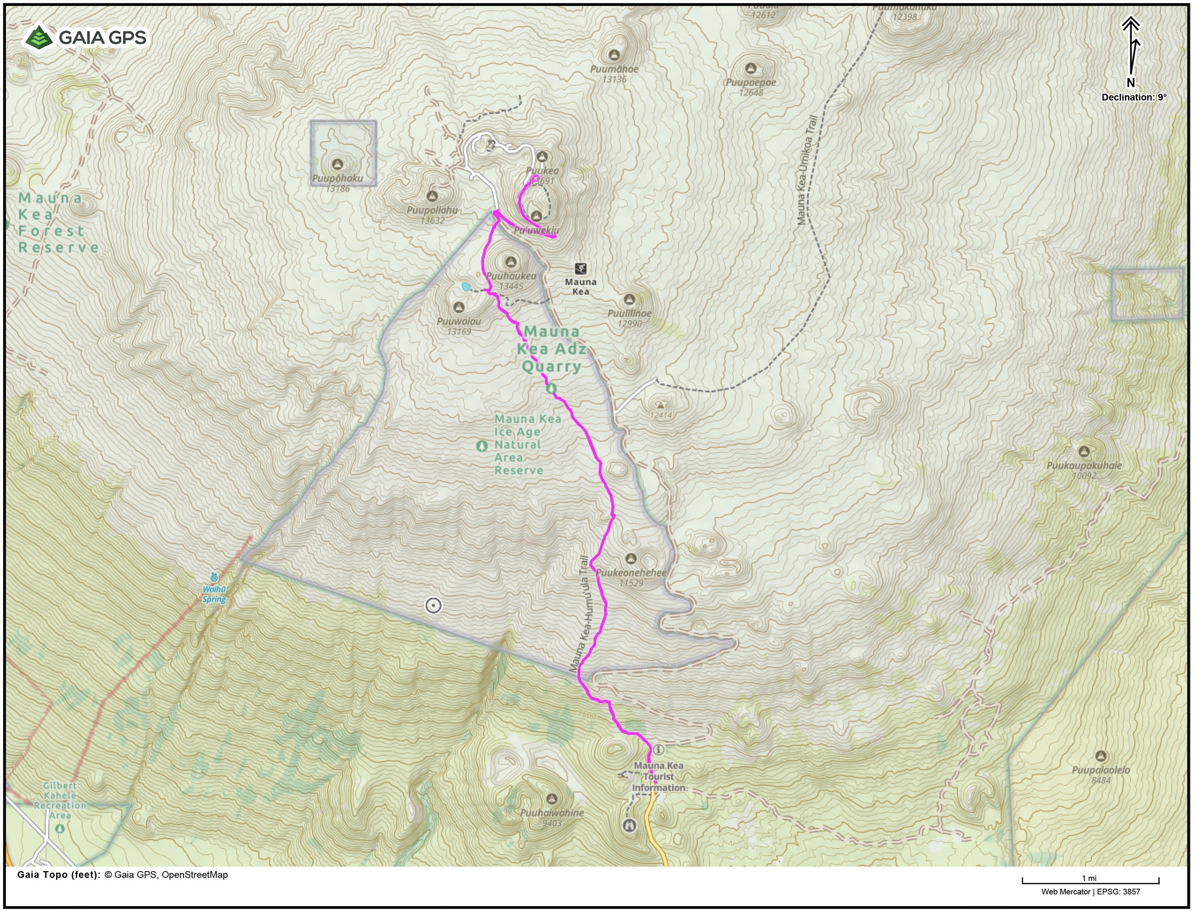
Hiking the Humu'ula Trail
Distance: 13.2 miles out and back
Elevation Gain: 4,500 feet
Estimate Round-Trip Time: 7 – 10 hours
Difficulty: The Humu’ula Trail is Moderate to Difficult. How challenging this hike will be has everything to do with how well-acclimated you are and your fitness level. A well-acclimated, in-shape hiker will find the adventure relatively easy if a bit long. The hike is all on-trail and the significant elevation gain happens over 6+ miles, so there's never any super-steep terrain. Expect about 6-8 hours if you're in good hiking shape.
Casual hikers and those not well-acclimated can expect a long day, making this a strenuous hike if you don't prepare for it. It's basically a half-marathon and if you're feeling the altitude, you'll likely be hiking at half-speed. It's still gettable if you adjust your pace and plan for a good 8 – 10 hours on the mountain. Slow and steady will do, but turn around if you start to feel awful from the altitude.
Class: The Humu'ula Trail is an accommodating, non-technical Class 1 path. The lower portion of the trail is sandy; at times, there will be brief, annoyingly loose hills. As you get higher, the sand gives way to volcanic rock and, eventually, a paved road.
The Hike

0.0 mi – From the Visitor's Center, walk north uphill on the road about 1,100 feet to the start of the marked trail on the road’s left (west) side. Note there are a few other short trails behind a metal guardrail on the left side of the road. Ignore these. The Humu'ula Trail starts past the end of the guardrail across the street from a driveway, just before the road turns from asphalt to gravel.
0.5 mi – At 9,500 feet, there is a trail split of sorts. Stay right (uphill), which will be the logical way to go. There is a sign designating the Humu'ula Trail but it doesn't have an arrow or mileage on it.
From this point on, you're cruising along the Class 1 trail. The sandy terrain underfoot gradually yields more stable rock. Most days, you'll be high above the clouds, and the views of the barren volcanic flats are spectacular. From time to time you'll see the access road to your right in the distance.
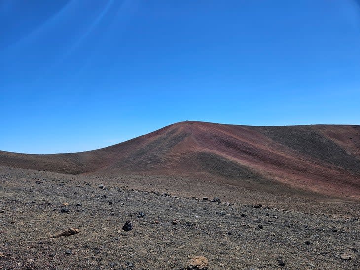
3.6 mi – At 12,300 feet, you'll arrive at the Mauna Kea Adz Quarry. This location is where generations of Native Hawaiians would harvest a precious type of basalt that was useful in the crafting of tools. The quarry was used from about 1,000 A.D. – 1,500 A.D. The section along the trail showcases an old rock shelter and some patches of distinct basalt.
4.6 mi – Reach the intersection of the Humu'ula Trail and the Lake Waiau Trail. Stay on the Humu'ula Trail to the top but if you'd like a quick detour, you can see Lake Waiau by going a few hundred feet west (left) on the Lake Waiau Trail at the top of a small hill. It's 0.2 miles from the junction to the lake itself, but since visitors aren't allowed to interact with the waters of the lake, the view from the top of the hill will do just fine.
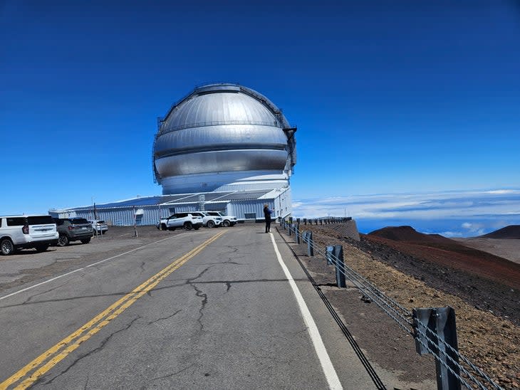
As you carry on past this junction, prepare for one of the most amazing sites on any hike in the world: the collection of observatories on the summit grounds. You're still a bit away from the top, but the big reveal of the white or silver domes planted in the volcanic crimson earth is quite moving.
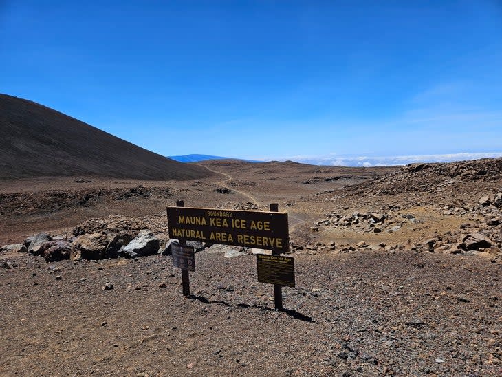
4.8 mi – Near the end of the Humu'ula Trail you'll pass through the Mauna Kea Ice Age Reserve. This unique geological area is one of the rare places in Hawaii that shows clear evidence of glacial transformation on the high volcanoes.
5.4 mi – The Humu'ula Trail ends at the road, once again boasting pavement rather than gravel. There are usually portapotties at this junction. The rest of the hike is on the paved road. Go right (east) at the junction of the paved roads, up the obvious steep uphill that leads to the summit area.
Hoof up this road as it hits a switchback and keeps climbing. Eventually, you'll reach a high point on the road where several impressive observatory domes stand.

6.6 mi – At the high point of the road, you're at the top! You'll see the geographic highest point to the southeast, with a trail blocked by the guardrail. There is a sign clearly saying the summit hill is off-limits to hikers. Despite the hiking path that has clearly been poached by others, please do not hike there. It is a sacred place to Native Hawaiians, and you get full credit for the summit at the top of the road.
There are Portapotties at the top. There is no public access to the observatories and no available water. Still, this is an amazing place to behold, so feel free to wander around. When you've had your fill, it's time to retrace your steps for the long hike down.
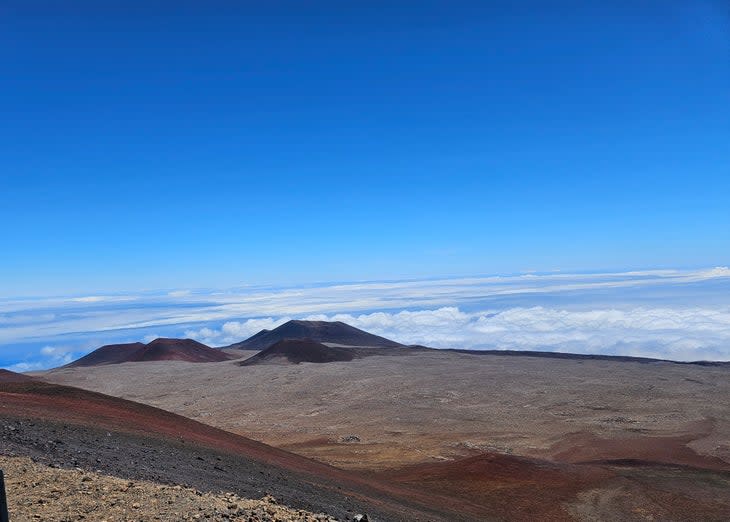
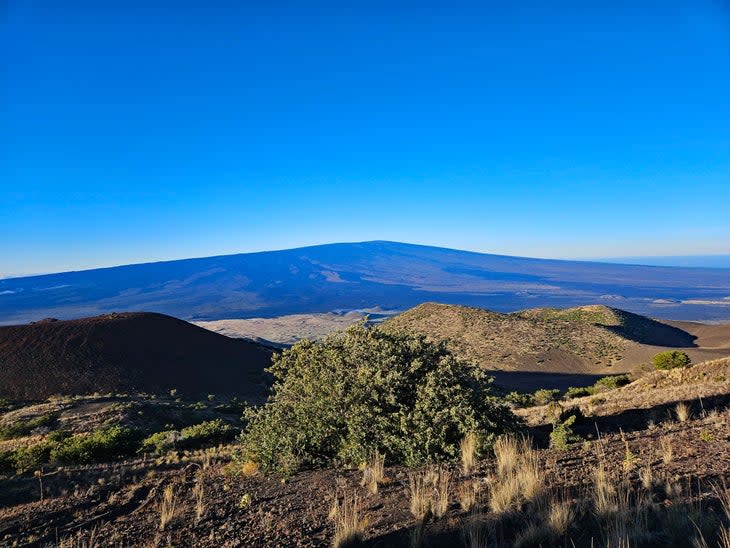
13.2 mi – After the long walk down--with views of neighboring Mauna Loa dominating the southern landscape--arrive back at the Visitor's Center.
Be sure to sign out when you complete your hike!
Final Thoughts
Mauna Kea via the Humu'ula Trail is one of the world's great summit hikes, no doubt about it. It takes some forethought and planning to do it right, but it's worth the effort. It's nice that there are other options for either a short hike via the Lake Waiau Trail or the ability to drive a vehicle to the top if that suits your travel plans better.
There's really no other place like Mauna Kea on the planet. From the leading edge of scientific technology to the ancient, raw rock that built the volcano, this hike is one-of-a-kind and one you'll never forget.
About the Author
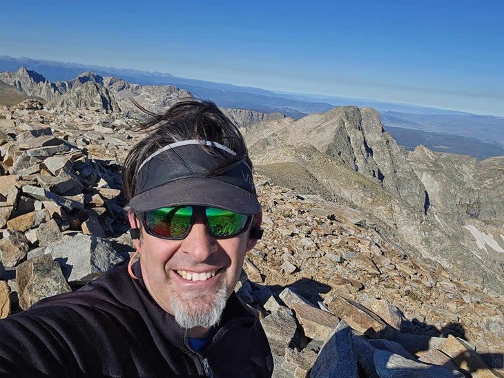
James Dziezynski is the author of several Colorado mountain hiking guidebooks and is a state highpointer (Hawaii was #44). He’s also the SEO Director at Outside/Backpacker.

For exclusive access to all of our fitness, gear, adventure, and travel stories, plus discounts on trips, events, and gear, sign up for Outside+ today.

