A Former National Park Ranger Reveals His Favorite Wild Places in the U.S.
This article originally appeared on Outside
Jon Waterman, a former ranger in Denali and Rocky Mountain national parks and a member (with Roger Mear and Mike Young) of the team to make the 1982 first winter ascent of the 20,310-foot Denali's Cassin Ridge, has spent a lifetime exploring the natural world. He has written 16 books, including In the Shadow of Denali, Kayaking the Vermilion Sea, High Alaska, Running Dry, Arctic Crossing, and the upcoming Into the Thaw (from Patagonia Books), in addition to making five films about adventure and wild places.
Waterman's most recent book, Atlas of Wild America, will be published October 3. Below, he explains his idea of wilderness and, in an excerpt from the book, reveals some of his favorite places in the far reaches of the U.S.
No place can truly be called wilderness, because the term is more a feeling about undeveloped landscapes, a subjective and often elusive state of mind rather than a defined geography. But more than ever before--and on the eve of the 60th Anniversary of the Wilderness Act--we need wild places as antidotes to the madding world and as balms for the soul. Wild places are essential amid population growth, diminished natural habitats, adjacent development of natural resources, and the climate crisis.
I've chased the wilderness ideal all my life. From Baxter State Park in Maine, where I cut my teeth as a mountaineer, to the cherished lakes in Minnesota's Boundary Waters. I paddled the Colorado River from source to sea, marveling at the wonder of its vast delta with a sky that feels as big as all the desert hemisphere. I took to the Arctic repeatedly, most recently through the remote Noatak National Preserve, struck by our greatest of all legislated wilderness areas. I've repeatedly climbed the Yukon's gigantic, ice-cloaked Mount Logan--hidden amid the greatest non-polar icefields on earth--in the seldom-visited Kluane National Park. I've taken to the granite or carried my skis into the ever popular John Muir Wilderness of California. These are six of my favorite trips and places.
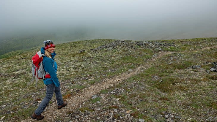
Baxter State Park, Maine
December 29, 1974: We left our tent at Chimney Pond in the dark, kicking steps up Katahdin in our double boots. When we reached tree line an hour later, I donned sunglasses and marveled at dawn as it sparkled off lake ice, then blazed over an infinitude of spruce stretching across the horizon.
My crampons squeaked against subzero neve as I continued up. Waist-high krummholz trees lay plastered with horizontally suspended daggers of rime ice that pointed to the lee as if to caricature the wind. Up above, rime encrusted everything: rocks, the summit cairn atop Pamola, and hair that hung below our balaclavas. As we descended down onto the Knife Edge for the final mile-long crossing to Baxter Peak, we threaded over and around frosted boulders and bashed off huge branches of rime with our ice axes to avoid being poked as we balanced along the precipice.
I had come to northern Maine to experience the ultimate New England wilderness. In this place that demanded self-sufficiency, I wanted to learn the craft of winter mountaineering on New England's most arctic mountain so that I could climb in the world's great ranges.
As I clambered slowly across the spine of a mountain sharpened by the last ice age, I focused on each step. Inches to the right, frosted slabs dropped more than a thousand feet to Chimney Pond. Then [Lee Nonemaker] yelled, pointing left: "The Brocken spectre!" We had been engulfed in mist, and the sun cast our clearly defined shadows--surrounded by strange rainbow halos--onto a thick cloud bank in front of us. We lofted our ice axes to the sky.
Boundary Waters Canoe Area Wilderness, Minnesota
September 12, 2021: Shaded by tall pines at a campsite in mid-Winchell Lake on a sunny afternoon, we promptly pitched our tents, assembled our fishing rods, and stepped back into the canoes. Over the last two days, none of us had caught a fish, and because we were eager to take a break from freeze-dried food, we paddled out into a narrow bay and started our casts.
The end of the bay bristled with sedges, and as Peter [Stock] and David [Rhude] worked those shallow waters, Gil [Bovard] and I cast into the depths alongside granite ledges below our campsite. Earlier in the day we had heard the persistent howl of a wolf, but this afternoon only a blue jay called, and the air laid still amid fragrant pine, loamy-smelling dead logs and the sweet rot of fall.
We returned with a large northern pike. After Gil expertly filleted the fish, we deflated its bladder, paddled the skeleton out, and reverently sank it in the deep water of the lake.
According to the Ojibwe origin story, back in a time when gods interacted with humans, there was an animal god named Wemicus. He had repeatedly killed off all but one of his human sons-in-law, but in a final birch-bark canoe race, Wemicus was outsmarted. Goaded by his last son-in-law, Wemicus capsized in his canoe in the wind. When the man paddled over to the spot where Wemicus had fallen into the water, he saw his father-in-law transformed into the pike.
Four hungry canoeists couldn't have been more thankful.
Upper Gulf of California Colorado River Delta Biosphere Reserve, Baja
December 2, 2008: At the border Pete McBride and I had paddled our pack rafts down an increasingly narrow stream that was once the mighty Colorado River. But within a day we were forced to carry our pack rafts and walk the route of 19th-century steamships. We bushwhacked and trudged through sands washed from the Rockies; baked by the hot sun, we perspired faster than we could drink. We stumbled south with blistered feet because it was no longer possible to float the last 90 miles to the sea.
Occasionally the river would reemerge in stagnant ponds shaded by cottonwoods and guarded by reluctant great blue herons, sentries of a former cornucopia. Most of the time we were lost in the dried-out maze of delta cut by farm fields and salty canals. Eventually, a small tributary, el Rio Hardy, resuscitated the delta.
Before the vast, dried-out sponge of a delta absorbed the large creek, we reinflated our boats and began to paddle. On the second day afloat, entering the biosphere reserve, we found an unexpected wet paradise. The glowing green phosphate water turned clear, scrubbed clean by a rowdy coiffure of reeds and plants.
These curlicues of hidden river were lush with an upwelling of underground water, temporarily arisen before it would be reabsorbed and blocked from the ocean by ancient sand grains spread as far as we could see. Here, briefly, nature endured: rattling kingfishers, squadrons of circling mallards, and hushed, stern-faced cattle egrets. We could smell the postcoital tang of ocean tides.
Tamarisk thinned. Salt grass bearded the ground. Pintail ducks, curlews, ibis, plovers, and black-crowned night herons fluttered and gabbled and splashed. Sere mountains surrounded us under an infinite sky bisected by a once unstoppable river that scarcely knew banks. As the stream narrowed, we could feel it gather momentum, as if it would once more meet the sea.
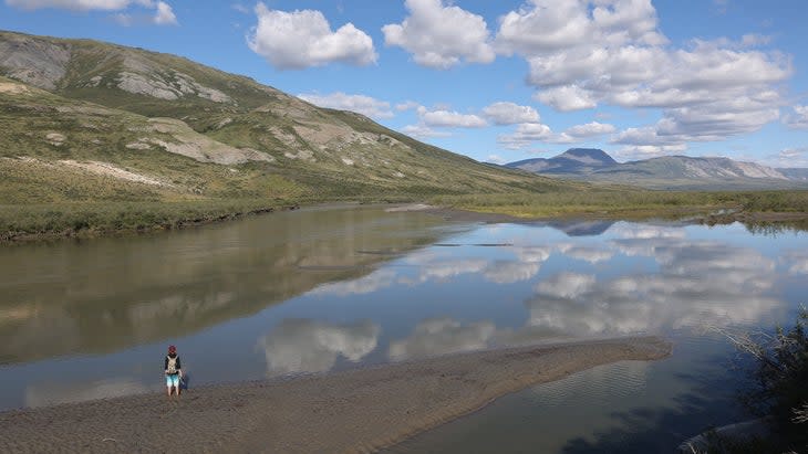
Noatak National Preserve, Alaska
August 5, 2021: As I rowed down the Noatak into the preserve, a golden eagle swooped silently 40 yards south. Then a bull caribou swam the river, its antlers held high like a waiter lofting a tray. It came ashore with a clatter over the river cobbles, then dashed out of sight into a thicket of dwarf birch.
We camped at a stream so gin clear that for once, amid America's greatest wilderness, I abstained from a filter, cupped my hands, and drank like a passing wolf from water so cold my teeth ached. My son Alistair looked at me as if I had gone mad.
Hungry, I cast repeatedly out into the cloudy Noatak River and reeled back in along the confluence of pellucid, insect-laden waters. When a fish hit the lure, I lifted the rod tip and a torpedo-shaped, silvery grayling swam quickly past my feet, where I guided it ashore and dispatched it fast and mercifully.
His colorful dorsal fin protruded like a sail, battened with a score of rails and bordered ruby red with freckled pink dots. His eyes still held the light, with shiny gold irises that circled night-black pupils bigger than any fish. To keep bears out of camp, I slit its belly in the cold water and briefly held his shiny entrails in my hand, with appreciation, before I released all that we could not eat into the current.
We minced garlic into spitting olive oil, and I sauteed the white meat, scales down. Wind blew against the stove, and I could imagine a bear miles downstream, standing up while parsing out floating molecules of fried fish through its nose.
With the spatula, I flaked the grayling out onto a half dozen plates. Before anyone could eat, my son said, sotto voce, "Thank you, fish." And as we all recited our thanks, it felt better than church.
John Muir Wilderness, California
April 8, 1993: In midweek after a big snow winter, we shouldered our packs at the trailhead hoping to ski Whitney and then continue a circumnavigation around the mountain. [Deborah Hutchinson and I] clumped uphill in our big boots, then cut off the broken mule trail and made our own trail in unbroken snow up toward Upper Boy Scout Lake, our skis like cumbersome antennae as they bumped Jeffrey pine branches and released the sweet smell of butterscotch. Atop the snow near the lake at 11,000 feet, we laid out our pads and slept contently under the stars--as if they provided heat on that cold night.
Before dawn under our headlamps, we unrolled the ski skins and strapped them to the skis, stepped into the bindings, and began walk-sliding up to Iceberg Lake. The Mountaineer's Route proved too steep to continue with skins, so we strapped the boards on our packs and continued kicking several-inch-deep steps in hard snow up the route. It took little more than hour to race one another to the notch just above 14,000 feet. We stashed our skis there and strapped on our crampons for the last steep bit. We frontpointed side by side up firm snow, with our ax picks a-squeak with every punch. Although our breath came in gasps, we were exhilarated by the dance of axes synchronized with crampons. Above all else in the lower 48, the sky seemed an impossible cobalt, and peaks stretched in a dazzle of white as far as we could see.
We had the broad, helmet-crested summit to ourselves, but with the temperature rising, we couldn't linger. Back at the skis, we clipped into our bindings with the snow now perfectly softened and corned up. We carved glorious turns, one at a time, slipping and sliding on velvet snow, arcing close to a hundred figure eights down, down, down in the footsteps of John Muir.
Kluane National Park, Yukon
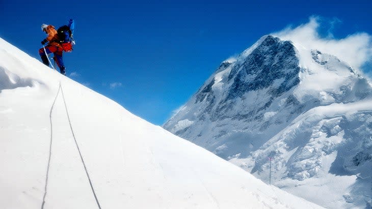
July 9, 1978: After nearly a month out, we had climbed all the blue ice pitches up and across the unclimbed West Ridge of Mount Logan (19,551 feet). But the last two days--as we drug our gear across the high plateau and wheezed through the 16,000-foot air--proved an incredible workout.
Before the sun disappeared on one of our final nights, [Steve Davis, Roger Hirt, George Seivwright, and I] laid out our black tarps on a sloping snowfield and shoveled snow on top. Within an hour, the intense sunlight absorbed by the black tarp began to melt the snow, and several quarts of water trickled down into our pots at the bottom. The technique had saved us nearly a gallon of stove fuel over the last weeks of travel through the frozen wilderness.
Then as the sun fell below the horizon--in the penumbral light that constitutes night in the summer subarctic--George and I broke trail for an hour's steady climb up to the North Peak. We couldn't stay long on top in 20-below temps, with our beards iced over and frozen snot-sicles tusking out of our nostrils, but we were rewarded by the view to the north: three vertical miles down to the ice fields, gilled like the flanks of sharks with dark crevasses and dozens of snow-covered peaks as far as we could see, with no trees or buildings or roads or humans anywhere. In between were several more peaks we still needed to climb on the Logan high-altitude plateau. Off to the south, like a great planetary reflection mirror, the Gulf of Alaska glowed across the whole horizon, and I couldn't help but shiver for how small it all made me feel. One look between us was all it took to signal our descent, and without words we hoofed it back down toward the tents, where our partners awaited with the last of the hot cocoa.
Jon Waterman lives in Carbondale, Colorado, and is a recipient of the National Endowment for the Arts Literature Fellowship and three grants from the National Geographic Society Expeditions Council. The second of three large atlases, Atlas of Wild America (National Geographic, October 3, 2023), which contains 251 maps or graphics and 310 photographs, follows the bestselling Atlas of the National Parks (2019). Atlas of Wild America is available to purchase here.

Also by this author:
For more information on backcountry travel:
For exclusive access to all of our fitness, gear, adventure, and travel stories, plus discounts on trips, events, and gear, sign up for Outside+ today.

