Extreme weather is outpacing worst-case scenarios of forecasting models
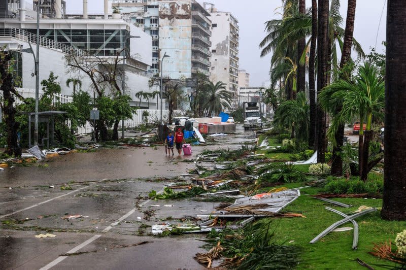
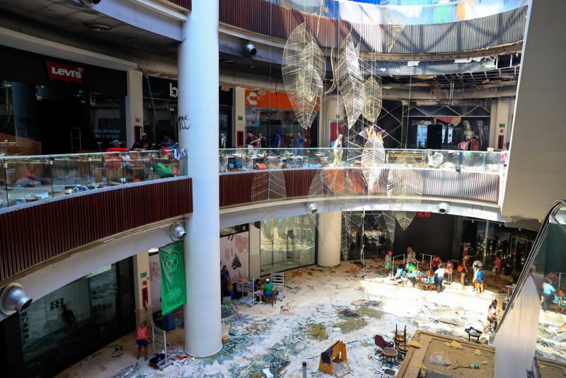
Oct. 31 (UPI) -- In the wake of the destructive Hurricane Otis, we find ourselves at a pivotal moment in the history of weather forecasting. The hurricane roared ashore with 165-mph winds and torrential rainfall, slamming into the coastal city of Acapulco, Mexico and claiming the lives of at least 48 people.
The speed at which Otis intensified was unprecedented. Within 12 hours, it went from a regular tropical storm to a "category 5" hurricane, the most powerful category and one which might occur only a few times worldwide each year.
This rare and alarming event, described by the U.S. National Hurricane Center as a "nightmare scenario," broke records for the fastest intensification rate over a 12-hour period in the eastern Pacific. Otis not only caught residents and authorities off-guard but also exposed the limitations of our current predictive tools.
I specialize in the study of natural disasters with the goal of improving our ability to predict them and ultimately to save lives. It is critical that we address the pressing concerns related to the tools we use for forecasting these catastrophic events, all while recognizing the significant influence of rapid climate change on our forecasting capabilities.
Predictive tools
At the core of weather forecasting are computer programs, or "models," that blend atmospheric variables such as temperature, humidity, wind and pressure, with fundamental physics.
Since the atmospheric processes are nonlinear, a small degree of uncertainty in initial atmospheric conditions can lead to a large discrepancy in final forecasts. That's why the general practice now is to forecast a set of possible scenarios rather than predict the single scenario most likely to occur.
But while these models are instrumental in issuing early warnings and evacuation orders, they have fundamental limitations and carry a significant degree of uncertainty, especially when dealing with rare or extreme weather. This uncertainty arises from various factors including the fundamentally chaotic nature of the system.
First, the historical data is incomplete, since a hurricane such as Otis might occur only once in several millennia. We don't know when an east Pacific storm last turned into a category 5 hurricane overnight -- if ever -- but it was certainly before modern satellites and weather buoys. Our models struggle to account for these "1 in 1,000-year events" because we simply haven't observed them before.
The complex physics governing the weather also has to be simplified in these predictive models. While this approach is effective for common scenarios, it falls short when dealing with the intricacies of extreme events that involve rare combinations of variables and factors.
And then there are the unknown unknowns: factors our models cannot account for because we are unaware of them, or they have not been integrated into our predictive frameworks. Unanticipated interactions among various climatic drivers can lead to unprecedented intensification, as was the case with Hurricane Otis.
Climate change
To all this we can add the problem of climate change and its impact on extreme weather. Hurricanes, in particular, are influenced by rising sea surface temperatures, which provides more energy for storms to form and intensify.
The connection between climate change and the intensification of hurricanes, coupled with other factors such as high precipitation or high tides, is becoming clearer.
With established weather patterns being altered, it is becoming even more challenging to predict the behavior of storms and their intensification. Historical data may no longer serve as a reliable guide.
The way forward
The challenges are formidable but not insurmountable. There are a few steps we can take to enhance our forecasting and better prepare for the uncertainties that lie ahead.
The first would be to develop more advanced predictive models that integrate a broader range of factors and variables, as well as consider worst-case scenarios. Artificial intelligence and machine learning tools can help us process vast and complex datasets more efficiently.
But to get this additional data we'll have to invest in more weather monitoring stations, satellite technology, AI tools and atmospheric and oceanographic research.
Since even world experts and their models can be caught out by sudden weather extremes, we also need to educate the public about the limitations and uncertainties in weather forecasting.
We must encourage preparedness and a proactive response to warnings, even when predictions seem uncertain. And of course we still have to mitigate climate change itself: the root cause of intensifying weather events.
Hurricane Otis provided a stark and immediate reminder of the inadequacies of our current predictive tools in the face of rapid climate change and increasingly extreme weather events. The urgency to adapt and innovate in the realm of weather forecasting has never been greater.
It is incumbent upon us to rise to the occasion and usher in a new era of prediction that can keep pace with the ever-shifting dynamics of our planet's climate. Our future depends on it.

Ravindra Jayaratne is a reader in coastal engineering at the University of East London.
This article is republished from The Conversation under a Creative Commons license. Read the original article.
The views and opinions expressed in this commentary are solely those of the author.

