Explore the Remote Grand Staircase-Escalante National Monument
This article originally appeared on My Utah Parks
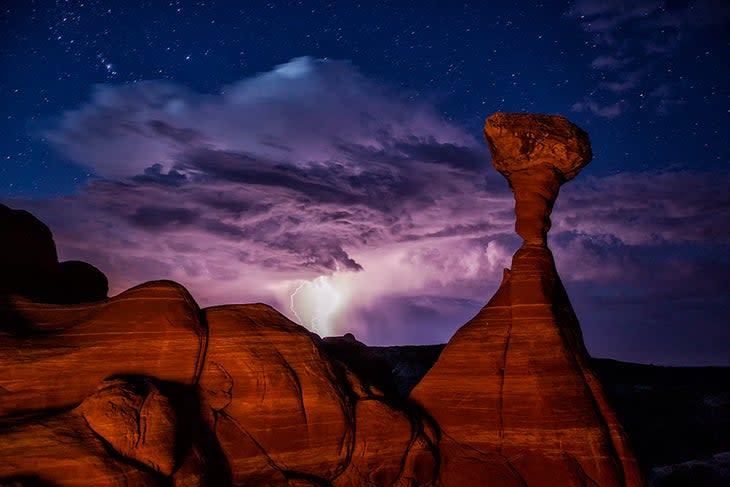
Grand Staircase-Escalante National Monument spans 1.87 million acres of central Utah stretching from the boundary of Bryce Canyon National Park in the west to the boundary of Capitol Reef National Park and Glen Canyon in the east. It stretches all the way to the Utah-Arizona state line to the south. This incredible national monument is home to a mind-boggling array of natural and human history from the staircase-like cliffs in the west to the arid Kaiparowits Plateau to the slot canyons formed by the Escalante River in the east. Throughout this wildly varied landscape rock art and other Native American cultural sites can be found, along with a huge array of dinosaur fossils.
In this remote and rugged national monument, visitors can find incredible solitude as they hike, canyoneer, camp, drive off-road vehicles and otherwise explore this stunning part of Utah.
What Is There to Do in Grand Staircase-Escalante?
Recreation in Grand Staircase-Escalante National Monument abounds. You could spend years exploring every nook and cranny and never get bored but what if you only have a few days?
Go For a Day Hike
There are plenty of incredible day hikes to choose from in Grand Staircase-Escalante from hidden waterfalls to slot canyons. One of the best reasons to go hiking in the monument is that the trails see a fraction of the crowds of the national parks. You may even find complete solitude on some trails, depending on the time of year.
If you like the idea of hiking through a narrow canyon but don't feel comfortable climbing or squeezing through tight areas, Willis Creek Slot Canyon is the perfect choice. At 4.5-miles round-trip, it's a fairly easy out and back trail that takes you through a beautiful canyon where the walls never narrow very far. Wear waterproof shoes as you may need to splash through the creek in parts. Access the trail on BLM 500 from Cannonville.
Near Boulder, find an oasis at Lower Calf Creek Falls. This 6-mile hike follows a creek along a sandy trail to a stunning 126-foot waterfall, perfect for cooling off at.
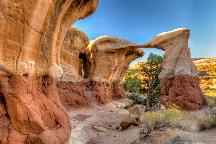
If you want the most bang for your buck, the hike to the Escalante Natural Bridge between Escalante and Boulder is one of the most rewarding trails in the monument. Hiking along the Escalante River (and sometimes through it), you'll see petroglyphs, an arch, a cliff dwelling and the namesake natural bridge. The trail is 4.4 miles.

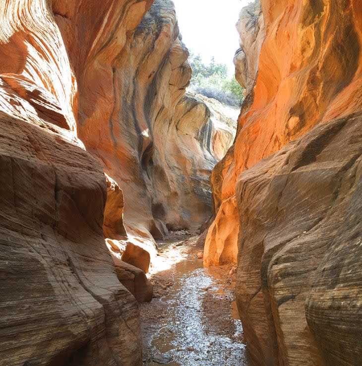
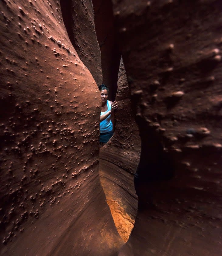
Tackle a Slot Canyon
Peek-a-boo and Spooky slot canyons are perhaps the most famous in all of Utah, and for good reason. Unlike many slot canyons that can be extremely dangerous if you don't have canyoneering skills, Peek-a-boo and Spooky are accessible to most hikers. The trail is only 3.5-miles round-trip, but expect it to take much longer than an ordinary hike as you'll be squeezing yourself through passages that are only 18-inches wide in some places, scrambling and otherwise navigating challenging terrain. Because of tight squeezes, larger people may have a more challenging time on this trail, and it may be challenging to navigate with young children and dogs.
Never start a slot canyon hike if there's rain in the forecast anywhere in the vicinity as flash flooding is a real and dangerous occurrence in the desert. Even the clearest of mornings can give way to afternoon storms, so don't be deceived and do your research on the weather for the day. The trailhead is located 26.3 miles down Hole-in-the-Rock Road.
Enjoy a Scenic Drive
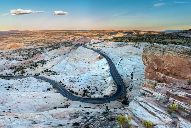
While not all of Scenic Byway 12 is in Grand Staircase-Escalante National Monument, this stunning road does wind in and out of the monument's northern end, making it a great way to experience the beauty of this remote part of the country.
Scenic Byway 12 is a paved, two-lane highway that runs from Torrey, Utah, the gateway to Capitol Reef National Park, west to Panguitch, Utah. This 123-mile road will take you through some of the most diverse and stunning landscapes in Utah.
From Torrey, you'll enter the Dixie National Forest, a sprawling 2.2-million-acre expanse of mountains, desert and lakes. You'll pass Capitol Reef National Park, which is worth a trip. In Boulder, don't miss Anasazi State Park where you can see an ancient Ancestral Puebloan village. Between Boulder and Escalante, steel yourself if you’re afraid of heights as you cross the Hogback. Here, the road runs along the top of a steep ridge, with sheer dramatic drop-offs on either side of the highway. Or, take a detour and drive Hell's Backbone, a rugged gravel road that runs from Boulder Mountain to north of Escalante. The road also follows a narrow hogback, as well as crossing the historic wooden Hells Backbone Bridge.
Outside of the town of Escalante, check out petrified wood at Escalante Petrified Forest State Park and then go for an incredible hike through the red rocks of Kodachrome Basin State Park.
Don't miss a stop at Bryce Canyon National Park to see the marvelous pink and orange hoodoos before driving through a rock arch on your way out to Hwy. 89.
If you're traveling in a four-wheel-drive, off-road capable vehicle, there are several OHV routes through the monument. Stop by a visitor center for information on these routes and road conditions.
Explore Overnight by Backpacking
There are tons of incredible backpacking opportunities in Grand Staircase-Escalante, though most are challenging since access to water is rare.
This is what makes Coyote Gulch a popular choice for backpackers. This narrow canyon never turns into a claustrophobia-inducting slot canyon and joins with the Escalante River, creating an oasis where backpackers can enjoy cool temperatures, shade and access to water from two natural springs. Along the way, you'll pass numerous arches and incredible rock formations.
Several trailheads access Coyote Gulch so you can build your own trip based on how many nights you want to spend under the stars, how far you want to hike and what you want to see. All trailheads are located off the rough Hole-in-the-Rock Road, which can be accessed just east of Escalante.
Most hikers either plan an out-and-back trip or hire a local guiding company, such as Excursion of Escalante, to shuttle their cars between trailheads to avoid having to hike long distances on Hole-in-the-Rock Road.
Reach out to the Escalante Interagency Visitor Center (www.blm.gov/visit/escalante-interagency-visitor-center) to talk to a ranger about route options before you plan your trip. You'll also need to stop here on your way to the trailhead to pick up a required permit, which is free.
Coyote Gulch is at risk of flash flooding when storms roll through, so avoid this area in the summer months and keep an eye on the weather to avoid a perilous situation. All human waste must be packed out of Coyote Gulch, and it's important to always camp in sites that have been previously used to limit your impact on this fragile environment.
Can You Drive Through Grand Staircase-Escalante?
There are several roads that run through Grand Staircase-Escalante National Monument allowing visitors to see the landscape and access trailheads. Most of them, however, are unpaved and can range from accessible in a two-wheel-drive car to unsuitable for anything other than a high-clearance, four-wheel-drive vehicle, depending on the road and weather conditions. Most of the monument is not recommended for drivers in RVs.
There are two paved highways that run through portions of the monument. In the south, Hwy. 89 connects Kanab, Utah, and Page, Ariz. You can access several trailheads on Hwy. 89 including the Toadstools, which are incredible, alien-looking rock formations. To the north, Scenic Byway 12 connects Capitol Reef and Bryce Canyon national parks and winds in and out of the monument along some of the prettiest stretches of road in the country. There are countless trailheads and scenic viewpoints on this route, but make sure to stop by either the visitor center in Escalante or Cannonville to learn more about the monument and plan your visit.
If you want to drive across the entire monument, you have two options: in the west, Cottonwood Canyon Road connects Hwy. 12 in the north with Hwy 89 in the south. In the east, Hole-in-the-Rock Road crosses the entire monument from Escalante to where it dead ends at the Glen Canyon National Recreation Area.
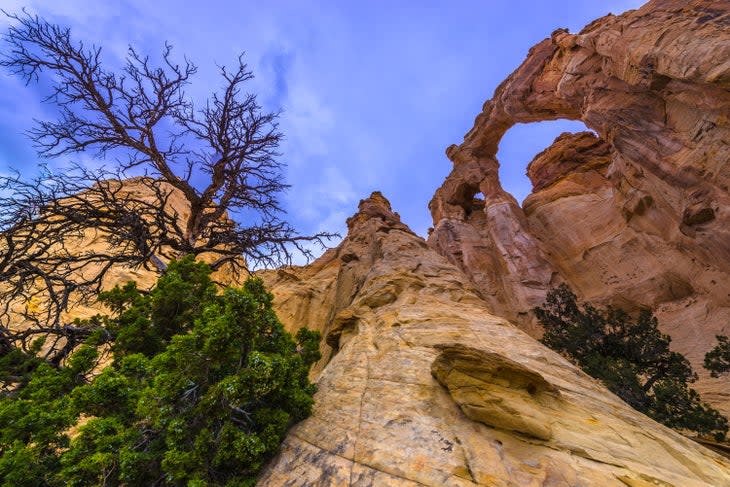
Cottonwood Canyon Road is a 47-mile dirt route that can be driven by a two-wheel-drive vehicle in good weather conditions and winds through a quite austere landscape and into the cottonwood-filled oasis of the Paria River. Access the southern end 46.5 miles east of Kanab on Hwy. 89 and the northern end is what Main Street in Cannonville becomes. Don't miss Grosvenor Arch approximately 18 miles from Cannonville along the way. Several trailheads are located along Cottonwood Canyon Road.
On the east side of the monument, the 62-mile Hole-In-the-Rock Road requires a high-clearance vehicle for most of the journey south and a four-wheel-drive towards the end of the road. Even a sprinkle of rain can make this road impassible to all vehicles, so only head out on a clear day and be sure to bring plenty of food, water and layers in case you get stuck out there. Access Hole-in-the-Rock Road (also labeled as Hole-in-the-Rock Trail on some maps) 5 miles east of Escalante off Hwy. 12.
Hole-In-the-Rock Road was originally created by Mormon settlers trying to access the Colorado River and it remains almost as remote today as it was in the late 1800s. Highlights on this route include Devils Garden at mile 12, which is an incredible rock formation, access to the Coyote Gulch trailheads that provide incredible backpacking opportunities and, of course Peek-a-boo and Spooky slot canyons, which are some of the most famous in the state. At the end of the road, you'll reach Hole-In-the-Rock where settlers blasted a path for their wagons to reach the Colorado River. The river has since been dammed to form Lake Powell, but you can hike from the road down to the water on the old wagon route.
There are many other smaller roads that will bring you to various parts of the monument. It's a good idea to stop at one of the monument visitor centers to get a map and chat with staff about road and trail conditions and whether your vehicle is equipped to handle your adventures. There are four visitor centers for the monument in Escalante, Kanab, Cannonville and Big Water.
How Much Does It Cost to Go to Grand Staircase-Escalante?
Unlike visiting Utah's national parks, it's free to visit Grand Staircase-Escalante National Monument. As long as the roads are accessible, you can visit the monument at any time for no cost. Conversely, there are very few services in the monument. Roads are not well maintained and bathrooms are few and far between and mostly consist of pit-toilets when they can be found.
Most importantly, you won't find rangers there to assist you if you need help so it's important to be well-prepared for even a scenic drive. Bring food, water and layers on any trip into the monument in case you get stranded. It's important to have a spare tire and know how to change it. Let someone know where you're planning to go and what time you plan to check back in with them so that if you get lost or stranded, someone can contact search and rescue for you. There is no cell service in most of the monument, and many roads can be deserted for long periods of time depending on the season.
Remember to practice Leave No Trace as there is no one to clean up after you here. Pack out all of your garbage, including toilet paper and fruit peels.
Where Do I Stay in Grand Staircase-Escalante?
There are three established campgrounds inside the monument. Whitehouse Campground is located on the south side of Hwy. 89 between Kanab and Big Water, and Deer Creek Campground is located along a side-road off of Hwy. 12 near Boulder. Calf Creek Campground, off Hwy. 12 between Boulder and Escalante, is the most developed of the three and has drinking water and flush toilets. All three campgrounds are first-come, first-served.
Otherwise, the rest of the monument is open to primitive camping, also known as dispersed camping or boondocking. This means you'll camp in a non-designated site with no amenities like trash cans, fire pits or toilets. You must pack out your solid waste when camping in the monument. When choosing a primitive campsite, be sure to choose an area that looks like it's been used before to minimize your impact. You must also camp at least 300 feet from corrals and water sources, and you can't camp at a trailhead.
Don't drive off the road unless there's obviously been other cars that have driven there before as you can easily damage the fragile landscape. Much of the monument is covered in cryptobiotic or "living soil" that helps keep erosion from occurring and lets hardy plants grow, protecting the ecosystem. Your tires or footprints can quickly destroy it. Learn how to identify cryptobiotic soil and stick to areas that have seen previous use to avoid making more of an impact. Pick up a free permit at a trailhead or visitor center before camping primitively.
If you plan to backpack, you will also need a free overnight permit, which can be obtained at a visitor center.
There is no lodging inside of the monument. If you are looking to stay in a hotel or an RV-friendly campground, you'll need to basecamp out of one of the surrounding towns such as Kanab, Escalante or Boulder.

When Is the Best Time to Visit Grand Staircase-Escalante?
Late spring and fall are the best seasons to visit Grand Staircase-Escalante National Monument. In winter, snowstorms often make the roads impassable. In summer, temperatures soar and afternoon storms can trigger flash floods.
The monument is huge and elevations range greatly so research the area you plan on visiting before deciding on what time of year to visit. While low elevations can see temperatures in the eighties in the spring months, it may still be snowy at higher elevations.
Always check the weather forecast before heading out into the monument as storms anytime of the year can turn dirt roads slick and strand you until they dry out.
Is Grand Staircase-Escalante Worth Seeing?
While Utah's national parks may attract most of the state's recreational visitors, it would be a mistake to miss Grand Staircase-Escalante National Monument on your next desert trip. While the remoteness and ruggedness of the monument make it more challenging to visit than a national park, those are the same features that make it so worth seeing. The incredible landscapes you'll encounter, trails you can enjoy and solitude you'll find are unmatched.
In 1996, President Clinton created the monument to preserve this unique piece of natural and human history. In the nearly three decades since its creation, scientists have made countless discoveries to help, as President Biden put it, "better understand our environment, our history, our planet's past, and our place in the universe." Scientists have conducted studies here that better help them understand the hydrology of Mars, new species of dinosaurs have been found here and nearly 600 species of bees have been identified at the monument. Grand Staircase-Escalante also protects cultural sites and the ancestral lands of the Paiute, Hopi, Zuni, Dine (Navajo), Ute, Jemez Pueblo, Ute Mountain Ute and Acoma people. Outdoor enthusiasts also fell in love with the land for its recreational possibilities. In 2017, President Trump reduced the monument's size by 860,000 acres, which spurred a national conservation movement to get the monument's boundaries restored to protect its natural and cultural resources.
In October 2021, President Biden restored the monument's boundaries to their former size. Today, it's worth visiting to see the magic that is Grand-Staircase Escalante.
For exclusive access to all of our fitness, gear, adventure, and travel stories, plus discounts on trips, events, and gear, sign up for Outside+ today.

