Could a New App Help You Safely Navigate the Backcountry?
This article originally appeared on Outside
Meet AspectAvy, an app made exclusively for skiing and riding in the backcountry using avalanche data to help users better predict when and where catastrophic events will occur in real time.
"This one app has the ability to save hundreds of lives in the backcountry every year," Co-founder Jeff Banks explains.
"Statistics on avalanches show a clear relationship between the stability of the snowpack and the slope angle in which avalanches occur," the site claims. "We use this information to provide recommendations that take the guesswork out of determining where the safe slopes are."
Since the 2020 through 2021 season, there have been approximately 84 U.S. deaths in the backcountry due to avalanches, according to the Colorado Avalanche Center. The vast majority of deaths are skiers which almost always double than any other activity including hiking, or snowboarding.
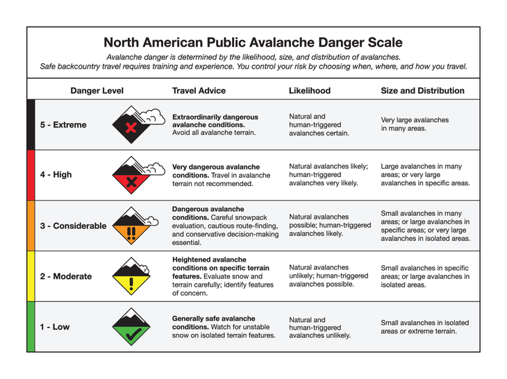
The team behind AspectAvy, a tech designer and an American Mountain Guide Association trainer and test administrator believe that all of these deaths could have been prevented, and that if users had been closely following the app they may still be here today. The app will take into account live data from the North American Public Avalanche Danger Scale, which works much like a fire safety danger sign that you may see outside of a campground or state park and rates avalanche conditions based on a variety of factors. The scale also notes that there are different danger levels depending on the elevation a skier is traversing through.
The app will also take into consideration "avalanche problems" which are generated through four different factors including the type or description of the avalanche, the location, the likelihood of an avalanche occurring, and the potential size. While it is nearly impossible to predict exactly what type of avalanche will occur, the Colorado Avalanche Information Center notes that avalanches have myriad personalities and the four factors will help predict as closely as possible.
In addition to the data from the avalanche danger scale, and avalanche problems the app will offer a map feature that will give users the safest possible route through the backcountry based on the information available. Using light detection and ranging, the same technology used by the National Oceanic and Atmospheric Administration AspectAvy will help users find the path of least danger for a backcountry tour.
"Lidar, which stands for Light Detection and Ranging, is a remote sensing method that uses light in the form of a pulsed laser to measure ranges (variable distances) to the Earth," according to the NOAA. "These light pulses--combined with other data recorded by the airborne system -- generate precise, three-dimensional information about the shape of the Earth and its surface characteristics."
Finally, the app will offer coaching to help users find their "blind spot" and address what might be keeping them in harm's way, "We help riders identify their blind spots by coaching them to avoid their biases, improve their planning and execute on processes that will effectively manage their risk," according to the app.
The app launches in the app store for iPhone today, and you can download it here. The creators note that the app is not a substitute for formal avalanche training.
For exclusive access to all of our fitness, gear, adventure, and travel stories, plus discounts on trips, events, and gear, sign up for Outside+ today.

