The Complete Guide to Grand Staircase-Escalante National Monument, From Slots and Slickrock to Spectacular Desert Drives
While it may not have national park status and sees fewer visitors than its more popular southern Utah “neighbors” like Bryce Canyon and Capitol Reef, Grand Staircase-Escalante National Monument is every bit as spectacular—plus off the charts on the solitude scale. It features a dramatic landscape of sandstone cliffs and slot canyons, picturesque washes and slickrock, prehistoric sites and even old Western movie sets.
This is one remote and rugged spot even by out-there Utah standards, so don’t expect a lot of amenities. But with its sprawling borders served by satellite towns and four visitors centers, Grand Staircase-Escalante offers everything you’ll need for a great adventure off the beaten path.
Related: Unique National Parks You've Probably Never Been To
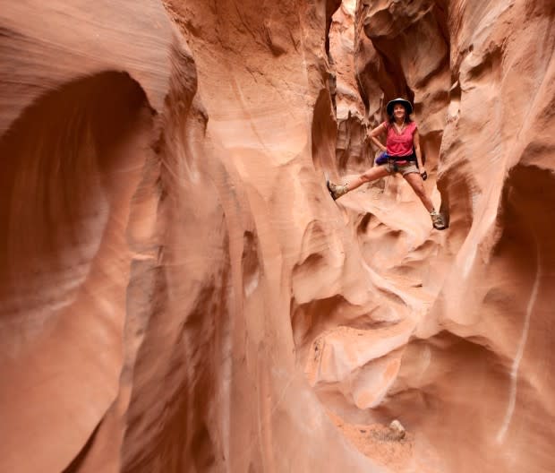
There’s a reason the mind-boggling labyrinth of canyons, creeks, cliffs and terraces surrounding Escalante was the last place in the lower 48 to be mapped. Spooky Gulch, Zebra Slot Canyon, and Coyote Gulch are among the many mysterious stone mazes worth discovering here, alongside towering waterfalls, paddle-worthy river canyons, incredible drives (paved or off-road), and an endless network of singletrack trails that are eons from all that Moab traffic. Home to a rich assortment of natural and human history, the landscape is a living museum of rock art and dinosaur fossils on top of its famed network of slot canyons—the largest set of them in the state.
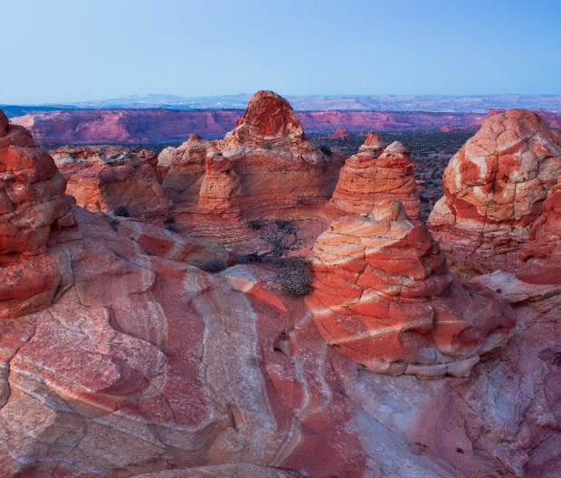
JTBaskinphoto
You can (and should) include Grand Staircase-Escalante during a week-long spin through southern Utah—hitting four of the country's most spectacular national parks in one shot. Given that Zion National Park, Bryce Canyon National Park, Capitol Reef National Park, and Grand Staircase-Escalante National Monument are all within about 200 miles of each other, why not? (And it’s not like the drive between them is shabby, either, from the towering gates of the Zion Narrows to the hoodoos of Bryce, slots of Escalante, and canyons of Capitol Reef.)
Here’s what you need to know before heading out to Grand Staircase-Escalante National Monument.
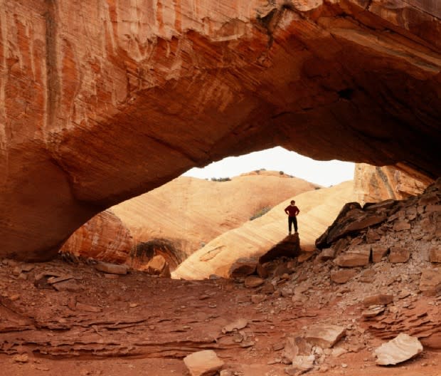
Suzanne Stroeer/Auro Photos
Where Is Grand Staircase-Escalante National Monument?
Sprawled across a good portion of southern Utah—and expanded in 2021 by the Biden administration to 1.87 million acres (larger than Delaware)—the monument runs from Bryce Canyon National Park in the west to the boundary line of Capitol Reef National Park in the east and stretches all the way south to the Utah-Arizona state line. Glendale and Kanab border Grand Staircase-Escalante to the southwest while another pair of small towns, Escalante and Boulder, rim its northeast section. As the monument’s hyphenated name suggests, the BLM-managed site has two main areas: Grand Staircase and Escalante Canyons, separated by the 1,600-square-mile Kaiparowits Plateau.
Grand Staircase is more remote, featuring the massive Paunsaugunt Plateau and Utah’s biggest network of slot canyons, as well as a variety of other prominent natural features from Paria River and Willis Creek to Lick Wash and Bull Valley Gorge. The more accessible Escalante Canyons sees more visitors, highlighted by the gulches of Escalante River and its tributaries.
How to Get to Grand Staircase-Escalante National Monument
Only a third of America’s scenic byways get the “All-American Road” distinction. Utah’s Scenic Byway 12 is one of them, connecting U.S. 89 near Panguitch on the west with Hwy 24 near Torrey on the northeast. While it’s not the quickest route between these two points, it’s certainly the most beautiful. It’s about the same drive from either Salt Lake City or Las Vegas to the monument (just under five hours) via I-15, hitting Hwy 12 from the south (Vegas) or north (Salt Lake City).
Through the Lens
Grand Staircase-Escalante National Monument Weather: Best Time to Visit
Unless you’re into seasonal extremes, the best time to come here is either in late spring or early-to-mid-fall. Summer brings high temperatures, plus frequent afternoon thunderstorms that can lead to flash floods. Winter is cold, and heavy snows can make the roads hazardous and impassable.
At any time of year in an area this huge and varied, it’s always a good idea to check the weather forecast before arriving, and gauge conditions according to what part of the monument you’ll be visiting. While temperatures in the lower parts of the monument may be in the 80s, higher elevations might get hit with snow on the same spring day. Some areas can be as dry as a bone, while rainy sections in other parts of the park can become dangerously slick.
Related: 50 Best Hikes in the World Every Adventurer Should Do in Their Lifetime
While there are no fees at any time to visit Grand Staircase-Escalante National Monument (unlike national parks), services offered here are far more limited and primitive, staffing is spare, and cell reception is minimal at best. Bring extra food, water, layers, and emergency items—and make sure that spare tire is there and properly inflated. Let someone know where you’ll be going and when you’ll be back.
As for those national parks in the area which do charge an entry free, visit them for free on any one of the following days: Fri., Aug. 4 (second anniversary of Great American Outdoors Act); Sat., Sept. 23 (National Public Lands Day); Sat., Nov. 11 (Veterans Day).
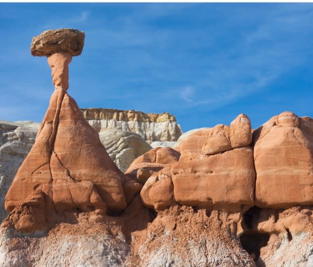
Scott Smith
What to Do in Grand Staircase-Escalante National Monument
Recreation options in this massive desert backcountry of canyons, rivers, slickrock, and scenic roads (paved or otherwise) run the gamut for adventurous hikers, bikers, backpackers, canyoneers, and drivers.
Hike
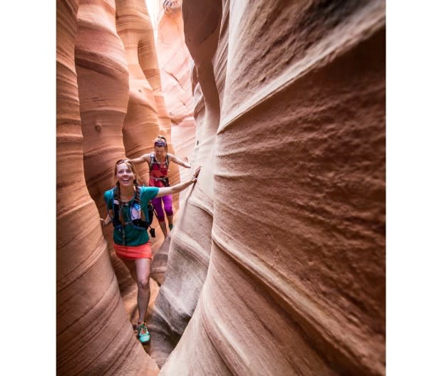
The monument’s unpeopled trails offer a level of solitude not found at many national parks, with several excellent day and multi-day hikes to choose from (see next section). Slot canyons here are famous even by Utah standards, and while many of them require solid canyoneering experience, there are also moderate ones open to most hikers and families.
Hotspots for hiking include the striped Zebra Canyon, Harris Wash, Coyote Gulch, and the hoodoos of Devils Garden, accessed via Hole-in-the-Rock Road, which heads southeast from Escalante toward Lake Powell. The monument doesn’t have any official entrances, but there’s a visitor center in Escalante, a smaller one in Cannonville, and you'll find Big Water Visitor Center and dinosaur museum down south.
milehightraveler
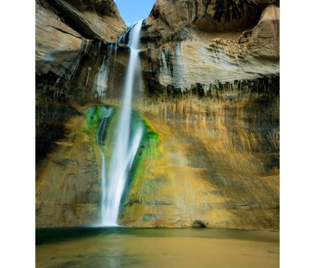
Calf Creek Falls is an easy and popular 5.7-mile roundtrip hike to a towering, 126-foot-high waterfall cascading into a large (and swimmable) emerald pool lined by a sandy beach. Look for the trailhead 17 miles north of Escalante on Hwy 12—and bring your dog (on a leash), who can cool off with a plunge. Want to ogle easily accessible rock art? A great hike on its own, Escalante River Canyon trail starts 13.3 miles north of Escalante on Hwy 12, just north of the Escalante River bridge, and leads to 100 Hands—a series of great pictograph and petroglyph panels—just a mile in.
Drive and Go Off-Roading
Driving here is an adventure unto itself, even along the area's two main paved routes. Scenic Byway 12 stretches nearly 125 miles from Capitol Reef National Park (at Torrey, UT) to Panguitch, UT, meandering in and out of Grand Staircase-Escalante National Monument along the way. Hwy 89 (from Kanab, UT, winding south into Arizona) skirts southern portions of the monument, passing several hiking trailheads along the way. The park's myriad network of unpaved backroads are best left to high-clearance and four-wheel-drive vehicles.
Burr Trail is one of the most underappreciated scenic roads in the country. Cutting through Capitol Reef, it was originally developed as a cattle trail by stockman John Atlantic Burr. Now, Scenic Backway (a mixture of pavement, gravel, and dirt) is one of the most picturesque drives in Utah. Winding through Long Canyon, it runs 35 miles from Boulder to its junction with Notom Road, which parallels the reef and takes you north another 33 miles to Hwy 24 just east of Capitol Reef National Park. Turn right at the junction and it leads another 30 miles southeast to Hwy 276 and Bullfrog Marina in Glen Canyon National Recreation Area. Take your time to explore viewpoints, namely Singing Canyon slot (mile 11.5 from Boulder) and Lower Muley Twist Canyon. Switch into low gear to get down the edge-of-your-seat switchbacks toward the end, serving up views of the snow-capped Henry Mountains.
Related: A Kayaker's Guide to Channel Islands National Park
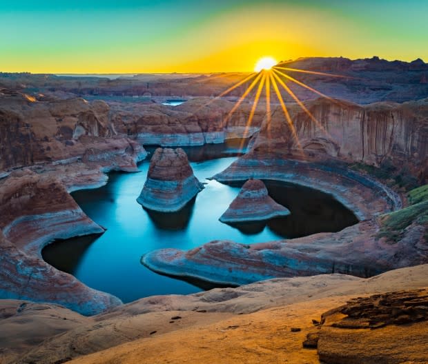
Paddle
For paddlers, Escalante River Canyon offers the monument’s holy grail of adventure in a remote 73-mile self-supported kayak, packraft, or SUP excursion landing in Lake Powell. Basic Class III skills are enough to navigate the rapids, although the biggest challenge lies in hitting the seasonal sweet spot for fickle river flows. In high or low water, the exotic canyon features more than a dozen side hikes into stunning slot canyons and along feeder streams filled with wild trout. Allow three to seven days to savor the canyon and book a boat shuttle from Powell’s Bullfrog Marina to minimize logistical stress.
Scott T. Smith
Mountain Bike
While Moab steals the mountain biking headlines, abundant slickrock, spectacular scenery, and secluded, technical trails make for a comparable mecca at Grand Staircase-Escalante. The monument remains one of the largest roadless areas in the West, but singletrack trails range from the high tableland of the Aquarius Plateau across Hell’s Backbone and into the hidden desert canyons that punctuate the landscape.
Slot Canyons Inn offers riding right out the door while Rim Tours out of Moab and Vegas-based Escape Adventures both provide multi-day packages for varying ability levels at both Grand Staircase-Escalante and Bears Ears National Monuments.
Alan Majchrowicz
Where to Stay in Grand Staircase-Escalante National Monument
Hotels, motels, and bed and breakfasts can be found in Escalante and Boulder to the north and other small towns throughout the monument. A favorite in Escalante is the pet-friendly Entrada Escalante Lodge, which has all the right touches: bowls, nametags, and treats for your pooch and a perfect porch for you.
Established campgrounds include Calf Creek (13 sites) and Deer Creek (seven sites), both first-come, first-served. Additional camping can be found at Kodachrome State Park and Escalante Petrified Forest State Park. Primitive camping is also allowed on BLM land. Want to glamp? Try Yonder Escalante, which has airstreams, RV sties, and cabins.
Best Guide Services in Grand Staircase-Escalante National Monument
Family-owned-and-operated Escape Goats offers guided hikes, shuttles, and more throughout the monument. Also try Excursions of Escalante, now in its 21st year of operation. It offers everything from hiking and canyoneering tours to shuttles and photography classes.

