The Best San Diego Hikes for Your Next Coastal Adventure
This article originally appeared on Outside
From our partners at Backpacker Magazine.
San Diego might be famous for its sunny climate, surf scene, and fish tacos, but it’s also a perfect home base for exploring a variety of classic Southern California hikes. From short jaunts overlooking the Pacific to long backpacking trips through the mountains, America’s Finest City is home to some of the state’s best trails.
Easy Hikes
Torrey Pines Beach Trail
Distance: 2.3 miles
Elevation Gain: 364 feet
Difficulty: Easy
Trail Type: Loop
If you're looking for a mild but gratifying beach hike, the Torrey Pines Beach Trail is a terrific pick. Located near Del Mar, this hike follows the coast for a little over a mile. You'll also hike past the rarest pine tree in the United States, the Torrey pine. As a popular hike, users should expect to see other visitors to this trail. Hike early in the morning to avoid too much exposure and snag a coveted free parking spot right next to the $15-25 trailhead lot. If you want to extend your hike, there are plenty of hikes in the Torrey Pines State Natural Reserve.
Los Penasquitos Canyon Trail
Distance: 6.8 miles
Elevation Gain: 157 feet
Difficulty: Easy
Trail Type: Loop
Hikers who are looking to take a break from the coastline should check out the desert views on Los Penasquitos Canyon Trail. Just 30 minutes north of downtown San Diego, this trail takes hikers down a mellow path with a section leading to a waterfall. It's kid-friendly, pet-friendly, and relatively manageable to people of a variety of ability levels. On average, the hike takes about 3 hours to complete. It features just 157 feet of elevation gain over nearly 7 miles--perfect for hikers who prefer flat but beautiful routes.
Sunset Cliffs Trail
Distance: 2.4 miles
Elevation Gain: 95 feet
Difficulty: Easy
Trail Type: Out and Back
Sunset Cliffs makes for a casual date night hike. This 2.4-mile out-and-back features ocean views as it traces outcroppings along the coast. Like many of the hikes in this section, it's relatively flat, so you can bring a friend (or a date) without worrying about their hiking experience. During your journey, you can even make your way down to the local tide pools to explore the ocean; bonus points if you can spot any starfish and sea urchins.
Borrego Palm Canyon
Distance: 3.2 miles
Elevation Gain: 450 feet
Difficulty: Easy
Trail Type: Loop
There's a solid argument to make that Borrego Palm Canyon in Anza-Borrego Desert State Park is one of San Diego's most overlooked hikes. Just 90 minutes from the city, this easy loop ascends 450 feet to a small shaded area where adventurers can relax or soak in the desert and rocky vistas. Spring hikers can find a perennial stream and wildflowers throughout the canyon. Although the manageable terrain invites hikers of all levels, new hikers sometimes have trouble navigating through the canyon. Be sure to bring a map or a navigation-savvy hiker along.
Annie's Canyon
Distance: 1.5 miles
Elevation Gain: 196 feet
Difficulty: Easy
Trail Type: Loop
Those who are looking for an easygoing hike in the San Diego area will find a lot to love in Annie's Canyon. This 1.5-mile hike, just 30 minutes away from downtown San Diego, is free, but not recommended for claustrophobic hikers. Climb ladders up and down to sandy washes and narrow, steep-walled slot canyons. This is a family-friendly hike, and dogs are permitted in the canyon. A big plus that it’s just a couple minutes drive from the ocean, so you can take a refreshing dip after your hike.
Tijuana Estuary
Distance: 4.6 miles
Elevation Gain: 45 feet
Difficulty: Easy
Trail Type: Out and Back
The Tijuana River County Open Space Preserve is a wetland habitat that's home to the American avocet (a large wading bird with a pink neck and blue legs), beavers, and unforgettable recreational opportunities. The Tijuana Estuary hike is a 4.6-mile walk that allows visitors to see plenty of wildlife from a relatively easy trail. Located near Imperial Beach, the trail is open year-round to hikers, bikers, and explorers. And due to the flat nature of the trail, most hikers are able to complete the whole trail in about an hour and a half.
Point Loma Tide Pools and Coastal Trail
Distance: 1 mile
Elevation Gain: 121 feet
Difficulty: Easy
Trail Type: Out and Back
This 1-mile trek takes adventurers down the coast of the ocean where they can explore the tideline for seaweed, shore crabs, and snails. It's dog-friendly, swimming friendly, and made for those who love to explore tide pools. Downside: There's a $15 parking fee.
Moderately Challenging Hikes
Cowles Mountain
Distance: 3 miles
Elevation Gain: 908 feet
Difficulty: Moderate
Trail Type: Out and Back
If you like to be the highest (literally) person around, you'll appreciate Cowles Mountain. This 3-mile trek to a 1,593-foot summit gives hikers 360-degree views of the surrounding hills and cityscape. This is also the highest peak in San Diego, making it a coveted bucket-list destination for locals. Due to the exposure, this hike is best first thing in the morning.
Cedar Creek Falls Trail
Distance: 5.6 miles
Elevation Gain: 1,049 feet
Difficulty: Moderate
Trail Type: Out and Back
Cool off at one of San Diego's most popular swimming holes by tackling the Cedar Creek Falls Trail. Head 50 minutes east of San Diego to make it to the trailhead, where you'll hike through a sandy wash, before crossing a small stream, and making your way up the canyon. The Cedar Creek Falls Trail is a relatively challenging route, leading hikers 5.6 miles through rocky terrain. As you make your way towards the popular swimming hole, you'll get views of the San Diego River Gorge. Hiking the Cedar Creek Falls Trail requires a permit ($10), which you can secure upon your entrance. When you arrive at the waterfalls, you'll get the chance to admire the 75-foot cliffs while going for a dip.
Potato Chip Rock (Mt. Woodson)
Distance: 7.3 miles
Elevation Gain: 2,119 feet
Difficulty: Moderate
Trail Type: Out and Back
Named after a thin rock feature that resembles a potato chip, Potato Chip Rock is one of San Diego's most Instagrammed spots. You'll have some company: Tourists come from everywhere to stand on top of this peculiar feature. It's just 35 minutes outside of San Diego, located in the town of Poway, but it requires a bit of physical exertion. The trail features some switchbacks and there's no shade along the way, which makes it a good morning or winter hike. This is also a popular bouldering hike since the trail is littered with big rocks. During weekends and holidays, parking costs $10.
Double Peak Trail via Discovery Lake
Distance: 4 miles
Elevation Gain: 1,036 feet
Difficulty: Moderate
Trail Type: Loop
Situated in San Marcos, California, the Double Peak Trail packs a waterside stroll and an easy summit into 4 short miles. Near the bottom, hikers will make their way past ducks swimming in Discovery Lake before navigating their way through a neighborhood, then climbing a moderate 1,000 feet to the summit. The trail is wide, and it features a number of spectacular vistas of both the city and the coast. The top of the hike offers picnic tables and a telescope for visitors to use. The average hiker should expect to take about 2 hours on this trail. Dogs are permitted, making it a great hike for furry friends.
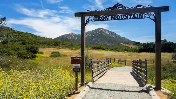
Iron Mountain
Distance: 5.9 miles
Elevation Gain: 1,125 feet
Difficulty: Moderate
Trail Type: Out and Back
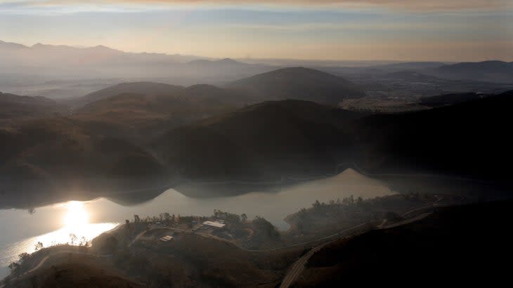
San Diego locals use Iron Mountain as a training peak for big adventures. It's also a secret spot for springtime wildflowers, which typically bloom in March and April. Located just 35 minutes from San Diego, Iron Mountain is an easily accessible adventure for anyone who needs a good workout. Rock lovers will be quick to notice the granite boulders across the mountain. Hikers who tackle this peak will make their way through a grove of oak trees and up a gradual dirt path, taking in views of the valley and a series of scenic cliffs as they go. The trail is popular, well-marked, and looks down on expansive views of the Del Cerro Reservoir.
Eagle Rock via the PCT
Distance: 6.2 miles
Elevation Gain: 836 feet
Difficulty: Moderate
Trail Type: Out and Back
Eagle Rock is one of the most well-known spots along the Pacific Crest Trail due to a peculiar rock formation shaped like, you guessed it, an eagle. This rock formation is completely natural. To make it there, you'll follow a seasonal brook through a grove of oak trees, prior to climbing to the feature itself. You'll also experience the extreme exposure of the desert as you climb to this iconic feature. Aside from Eagle Rock's patriotic features, it's also a popular hike because it's both pet and family-friendly. This trail is best tackled in the Spring, Fall, or Winter. Hikers in the San Diego area can drive 1.5 hours to Warner Springs, where the 6.2-mile trail climbs a gentle 836-feet prior to taking them to the eagle. The average hiker should put aside about 3 hours to complete the trek through oak woodlands and granite outcroppings.
Three Sisters Falls
Distance: 4.1 miles
Elevation Gain: 984 feet
Difficulty: Moderate
Trail Type: Out and Back
The Three Sisters Falls hike is known for both its sheer beauty and its deadly features. In fact, this hike is often underestimated, leading to about one death per year. Due to the trail's 45-degree descents, boulder fields, and slippery conditions, this trail can be quite challenging. But it's worth it. These three cascading waterfalls give hikers stunning vistas and a place to cool off on a warm day. This 4.1-mile hike is a moderately challenging trail near Julian, California that takes adventurers to three waterfalls, measuring about 30 feet, 30 feet, and 150 feet in height. But, if you're hoping to see the waterfalls in all their majesty, this hike is best tackled in the early spring time since the waterfalls can dry out in the summer. Dogs are welcome in this region.
Challenging Hikes
Cuyamaca Peak via Azalea Glen Loop
Distance: 7.7 miles
Elevation Gain: 1,833 feet
Difficulty: Hard
Trail Type: Loop
If you're a peak bagger, you have to check out Cuyamaca Peak. Cuyamaca Peak is San Diego county's second tallest peak, measuring 6,512-feet.. the 7.7-mile hike climbs 1,833 feet through a conifer forest to get to the top. On clear days, you can expect to see features that are 100 miles away like the Coronado Islands in Mexico. The Azalea Glen Loop is straightforward and easy to follow, which makes it a great hike for strong beginners. You'll make your way through an old burn area before climbing up to 360-degree views. There's no better way to see San Diego than from this summit. On average, it takes hikers somewhere between 3 to 4 hours to complete. But be sure to note that there is a parking fee by vehicle, and the hike is not pet friendly. But those who are hoping to find a weekend getaway can arrange camping nearby.
El Cajon Mountain
Distance: 11.1 miles
Elevation Gain: 3,579 feet
Difficulty: Hard
Trail Type: Out and Back
One of the toughest trails that you'll find near San Diego is the El Cajon Mountain trail. This out-and-back offers 3,579-feet of elevation gain and views of everything from Palm Springs to Mexico, including the San Diego skyline. It also takes hikers past mines, a glimmering lake, through loose gravel, and over a ridgeline. Generally considered the hardest hike in San Diego, this trail is often hot, exposed, and challenging to even the fittest hikers. If that sounds like you, however, it's a great hike to grab a half-day respite from the city.
Big Laguna Mountain Loop
Distance: 10.3 miles
Elevation Gain: 1,167 feet
Difficulty: Hard
Trail Type: Loop
Interested in hitting into the PCT for a day? Head to the Big Laguna Mountain Loop Trail. This trail overlaps with the PCT and follows the eastern crest of the Laguna Mountains, mixing alpine views with jaunts into oak and pine forest.. Best of all, it's just an hour drive from the city. Over the course of the 10.3-mile loop, hikers can expect to climb 1,167-feet; while long, it's not as rugged or steep as it could be. It's also accessible year-round, which can make it a convenient pick for avid adventurers.
Boucher Trail and Palomar Mountain Loop
Distance: 10.1 miles
Elevation Gain: 1,519 feet
Difficulty: Hard
Trail Type: Loop
Interested in trading San Diego's scenery for conifer trees, luscious meadows, and vibrant plants? If so, the Boucher Trail and Palomar Mountain Loop is for you. An hour and a half drive northeast of San Diego is the Boucher Trail and Palomar Mountain Loop. This 10.1-mile trail is a difficult trek that takes hikers up to 360-degree views of California, Mexico, and the coast. As you walk you'll travel through the trail's pine forests, you'll pass a fire tower that you can climb up to views of the nearby peaks and valleys. A highlight for most hikers, the fire tower is both a historical landmark, and an opportunity to see San Diego from up high. There's a $10 parking fee in the state park, but it's well worth it. Hikers should expect to take 4.5 hours to complete this hike.
For exclusive access to all of our fitness, gear, adventure, and travel stories, plus discounts on trips, events, and gear, sign up for Outside+ today.

