The best desert hikes to try in metro Phoenix now that it's finally cooling off
Autumn changes everything in the Valley of the Sun. Autumn means that overflowing bowls of Halloween candy are acceptable décor and pumpkin spice flavor is added to everything from coffee to cookies to dog food to deodorant.
Most of all, the season means it’s time to start hiking in the desert again.
Winter visitors will soon flock to town but for right now, the parks and preserves belong to residents. Take advantage of this quiet time to get out and explore some of the amazing neighborhood trails.
Here are five great desert hikes across metro Phoenix.
Best day hikes in Phoenix: Easy, scenic trails to try this weekend with family, friends
Phoenix: Deem Hills Recreation Area
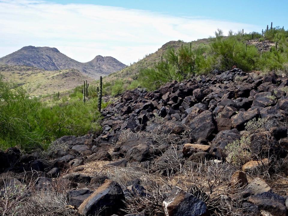
The Deem Hills in northwest Phoenix should be on everybody’s Halloween hiking list. With slopes as black as a witch’s hat, they make an otherworldly, apocalypse-flavored getaway — just right for the season.
All sorts of options are available via a network of interconnected trails, but for something quick and quiet, combine Circumference Trail with Palisade Trail for a stealthy little loop.
From the east trailhead, start on the Circumference Trail then immediately turn uphill on paved Water Tank Road. After a quarter-mile the Palisade Trail branches to the left, continuing to climb through a field of black basalt boulders adding that seasonal touch of menace.
According to trailhead signs, the boulders are remnants of ancient lava flows from volcanoes in the Flagstaff area that broke through the Earth’s surface here. For the rest of the hike, I’m obsessed with the idea that there’s an underground lava tube, an old once-molten subway, beneath Interstate 17, stretching all the way to Flag.
Atop the hill, Palisade intersects and joins the Basalt Trail for a short jog through desert scrub before they separate. Soon afterward, Palisade bends sharply east following a ridge. Views stretch to different corners of the Valley.
I pass a couple of connector paths to Circumference Trail, one right after another. Handy in case you need to shave off a little time. But I follow Palisade until it dead-ends at Circumference after 1.5 miles.
A left on Circumference and I make my way back down the slope covered with the blood of prehistoric volcanoes.
Trailhead: 27428 N. 39th Ave., Phoenix.
Admission: Free.
Length: 2.7 miles round trip.
Difficulty: Moderate.
Details: 602-495-6939, www.phoenix.gov/parks.
Phoenix: Sonoran Preserve
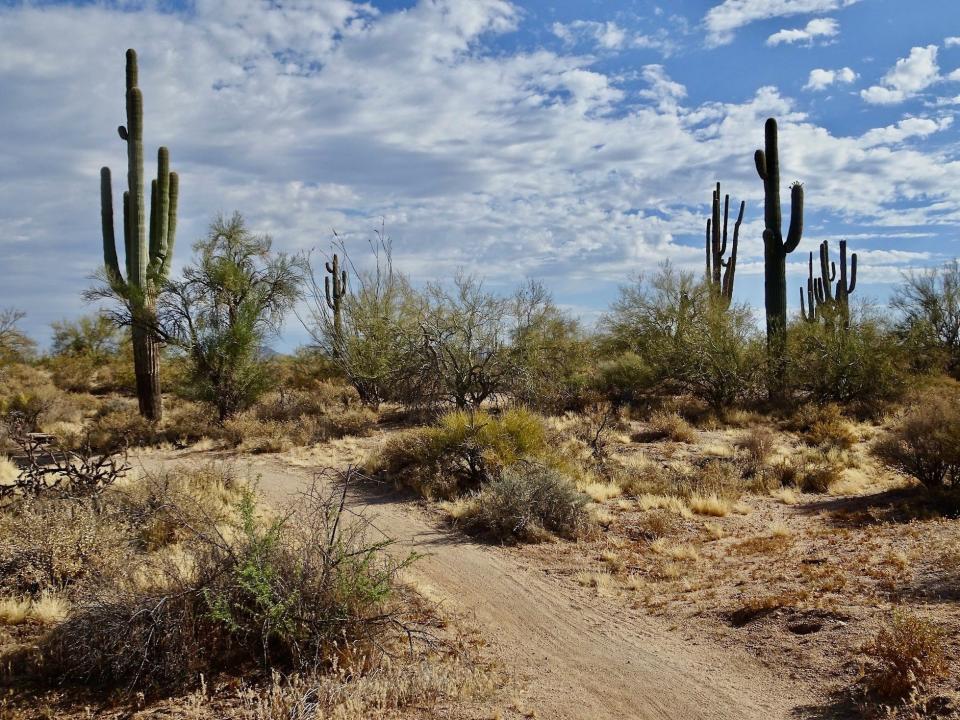
The Dixie Mountain Loop has an urban address but it beats with a wild country heart. It snatches you away from civilization in a matter of minutes.
From the Desert Vista Trailhead in north Phoenix, the Hawk’s Nest Trail unlocks this corner of the Sonoran Preserve. Make the short (0.4 mile) climb to a small saddle where Dixie Mountain Loop fans out in both directions.
According to the website, going counterclockwise softens the ascents so that’s what I do. But I’m the only one. Half a dozen hikers pass me heading in the opposite direction so maybe locals have a different opinion. Either way, it’s a pretty gentle ramble.
The city vanishes behind a ring of hills and I’m left with unbroken desert. Following recent storms, the slopes are pleasingly green. Rain-swollen barrel cactus are plump as baby walruses. Teddy bear chollas are everywhere, fields of them growing like a cash crop. Morning sunlight splinters on those spines in small silver bursts. Watch for stray cholla segments in the trail, eager to hitch a ride on any passing shoe.
To spice up your workout, two spur trails offer short but mildly steep summit climbs.
Near the end of my hike I pass the rusted skeleton of an old SUV perched in an arroyo. I ponder the lengths desert dwellers will go to find a shady parking spot. One last moderate climb and I’m back at Hawk’s Nest. With a healthy population of brittlebush, this also makes an excellent springtime hike.
Trailhead: 1900 W. Desert Vista Trail, Phoenix.
Admission: Free.
Length: 4.3 miles round trip.
Difficulty: Easy to moderate.
Details: 602-495-6939, www.phoenix.gov/parks.
Scottsdale: McDowell Sonoran Preserve
The reasonably new Pima-Dynamite Trailhead opened up another quadrant of Scottsdale’s McDowell Sonoran Preserve. And one of the best trails to access it is Axle Grease.
Fast and flowy, the Axle Grease Trail tracks almost due north, breaking away from the power lines with swooping curves through open desert. I detect the fine hand of mountain bikers in the construction of the trail, the way it glides over the landscape.
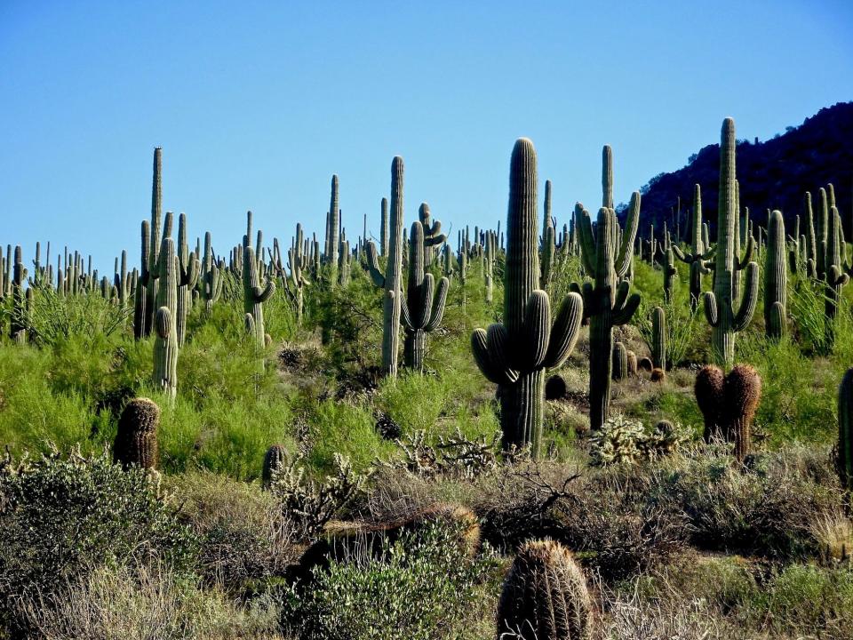
It also passes some impressive saguaro groves. Groupings of the lean giants tower over the trail.
Axle Grease stretches for 4.5 miles so it is a good out-and-back hike or a way to probe deeper into the preserve. But interconnected trails make it easy to create a customized loop.
I turn right on Rock Tank Trail as it crosses a shallow basin. The trail squeezes through rough boulder clumps adding interesting texture to the hike for almost a mile before connecting to Latigo Trail.
Turn right on Latigo and almost immediately Sidewinder Trail branches off and leads to desert royalty, an exquisitely formed crested saguaro. The tall trunk of the cactus cascades into a classic fan-shape — a picture book representation of a crested saguaro. Sidewinder rejoins Latigo and returns to the trailhead.
Trailhead: 28777 N. Pima Road, Scottsdale.
Admission: Free.
Length: 4.1 miles round trip.
Difficulty: Easy.
Details: 480-312-7013, https://www.scottsdaleaz.gov/preserve.
Goodyear: Estrella Mountain Regional Park
The Baseline Trail offers a quick fun hike that can be turned into a longer one. It’s also ideal if you’re in the mood for a fall picnic.
The trail is easily accessed from multiple trailheads. I set out on wheelchair-accessible Gila Trail, which begins from the Turf Picnic Area (see what I mean?) with numerous ramadas and shady tables scattered among the mesquite grove.
At the end of the wide, smooth Gila Trail (0.2 mile), an unsigned path pushes into the hills connecting to Baseline Trail. I turn right and cross the lean desert. Vegetation is sparse on these rocky slopes. It’s mostly creosote, buckhorn cholla, paloverde trees and a few skinny saguaros.
Baseline wraps around one of the front foothills and offers wide views that usually include a little bit of city. There are enough up and downs to make you feel like you accomplished a modest workout while still allowing you to carry on a conversation.
You’ll pass several trail junctions if you want to wander deeper into the mountains. Otherwise, finish the loop and hurry back to your picnic spread.
Trailhead: Casey Abbott Drive South in Estrella Mountain Regional Park, 14805 W. Vineyard Ave., Goodyear.
Admission: $7 per vehicle.
Length: 2.1 miles round-trip.
Difficulty: Easy.
Details: 602-506-2930, ext. 6; https://www.maricopacountyparks.net.
More: Dog-friendly hiking trails around Phoenix
Mesa: Usery Mountain Regional Park
Usery Mountain Regional Park may be the greenest corner of Sonoran Desert in the Valley. The place always feels lush with forests of saguaros, a supporting cast of smaller cactuses and a secret garden of leafy shrubs.
Most folks show up to hike the crazy popular Wind Cave Trail but I think the long loop that circles Pass Mountain delivers more bang for your hiking buck.
From the Trailhead Staging Area, I turn left onto the Pass Mountain Trail heading north. This means I’ll make a gentle ascent from the valley floor to a high saddle with a steeper descent on a rocky path. If you prefer getting the climbing out of the way sooner and coasting back down, go counterclockwise.
It’s a lovely ramble through scenic desert along the base of the mountain. I scoot past the Wind Cave Trail, already bustling with people.
As the trail curves around the northern tip of the mountain it tops a ridge and expansive views suddenly open up to the east and the south. The cactus-clad valley is framed by mountain ranges, including the Goldfields, Four Peaks and Superstitions.
The skinny path hugs the contoured slopes of Pass Mountain amid a cradling stillness. The city is a distant memory through here. At 4.3 miles I reach the saddle, a wide notch in the cliffs.
I relax on the shady ledge while enjoying the big drama-filled window and letting my legs rejuvenate. They need to be rested before plunging down the trail littered with assorted toe-banging rocks. Saguaros gather round again and some rooftops loom before I angle back to the trailhead.
Trailhead: Trailhead Staging Area in Usery Mountain Regional Park, 3939 N. Usery Pass Road, Mesa.
Admission: $7 per vehicle.
Length: 7.5 miles round trip.
Difficulty: Moderate to difficult.
Details: 602-506-2930, ext. 4; https://www.maricopacountyparks.net.
Find the reporter at https://www.rogernaylor.com. Or follow him on Facebook at https://www.facebook.com/RogerNaylorinAZ or Twitter @AZRogerNaylor.
Support local journalism. azcentral.com
This article originally appeared on Arizona Republic: Best desert hikes in Phoenix: Trails for fall, winter spring

