These Amazing Hiking Trails in Sedona Lead to Red-rock Arches and Hidden Energy Vortexes
Sedona is known for its red-rock landscape — and these hiking trails are true local favorites.
Brower Creative and The Sedona Chamber of Commerce & Tourism Bureau
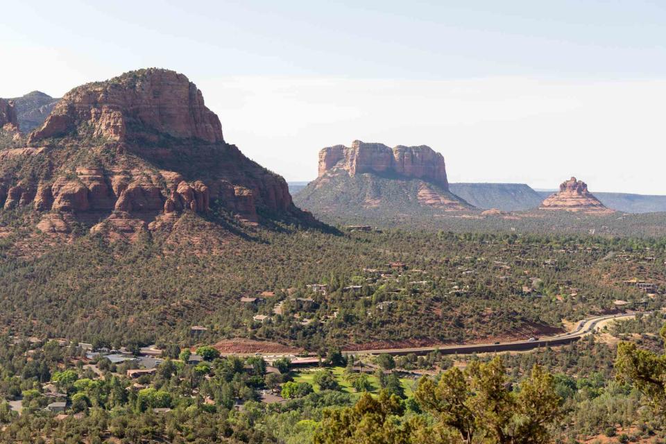
Sedona has long been considered an Arizona oasis. It's surrounded by red-rock buttes and pine forests, and houses a world-renowned arts and wellness community — with quirky New Age shops, high-end galleries, and more than its fair share of spas. Meanwhile, trailheads circle the outskirts of the city, marking the entrance to the undeveloped red-rock landscape.
“As a resident [of Sedona] for 24 years, I can tell you the saying that ‘God created the Grand Canyon, but he lives in Sedona,’ is true. Sedona is a place you have to see and experience in person to get the full effect,” said Heather Hermen, a public relations representative for VisitSedona.com, in an email interview with Travel + Leisure.
And when it comes to hiking, Sedona is second to none. With warm year-round temperatures and a terrain that begs to be explored, the landscape surrounding the city is a veritable outdoor playground.
“Sedona is, without a doubt, the day hike capital of America. I know it's a bold statement, but it's completely true,” said Derek Bond, director of activities and adventure at Enchantment Resort, in an email interview with T+L. “Our Red Rock Country is only 18 square miles and filled with more than 400 miles of trails. A scenic five- to 10-minute drive in any direction will give you access to beautiful red wall canyons and high mesas with sweeping panoramic views.”
Thanks to these experts, and some Sedona intel of our own, we’ve curated a list of some of the best hikes in Sedona, including a strenuous trek that’s nicknamed the “Sedona Stairmaster” and a mellow route that passes by one of Sedona’s most renowned vortexes.
Hangover Trail
Stan Rose and The Sedona Chamber of Commerce & Tourism Bureau
For a taste of Sedona’s unique red-rock terrain, Bond recommends the Hangover Trail, noting that it's “unique to Sedona as it allows you to hike for miles along elevated slickrock slabs, leaving you feeling like you're walking across some sort of martian landscape.” You can hike the full loop at 8.2 miles, or take the truncated 5.8-mile out-and-back route. Both include a hike on the Munds Wagon Trail, which is known for its sunset views.
Baldwin and Templeton Trail
A walk along Oak Creek on the Baldwin and Templeton Trail is a great way to adjust to Sedona’s relatively high elevation — 4,350 above sea level — and dry climate. Start at the Baldwin Trailhead and enjoy the leisurely 1.8-mile out-and-back route.
Bond calls it “the most beautiful walk along Oak Creek with the opportunity to visit my favorite vortex site.” A vortex is a place that seems to be particularly alive with energy — and it’s worth noting that Sedona is full of such spots.
Pyramid to Scorpion Trail Loop
Brower Creative and The Sedona Chamber of Commerce & Tourism Bureau
Scorpion Trail takes off right behind Sedona High School at Schuerman Mountain trailhead. Hike along Scorpion Trail before turning onto Pyramid Trail and completing the loop. This route is a favorite of Hermen’s, who says “the view of Sedona from the west looking east provides a different perspective with Cathedral, Bell Rock, Thunder Mountain, and more.”
For a shorter but similar route, start from Pyramid Mountain trailhead and do the 2.2-mile loop, skipping the Scorpion Trail lead-up.
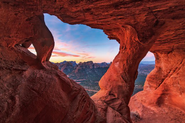
Sterling Pass Trail
Hikers will find the trailhead for Sterling Pass just off State Route 89A, north of Sedona. This 5.1-mile out-and-back trail is rated as “hard” on AllTrails for the steep climb that starts right from the trailhead. The climb is punctuated with beautiful overlooks, providing hikers with an excuse to take a break, have a snack, and enjoy the views.
The route is one of Bond’s favorites, who describes it as a “hike up and over a true mountain pass with a secluded natural arch as the destination.”
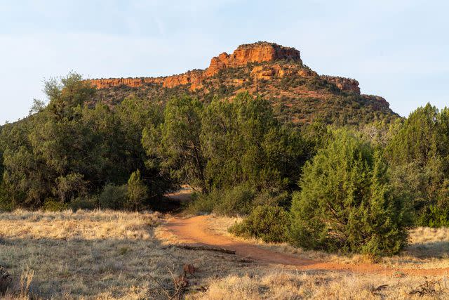
Bear Mountain Trail
Stan Rose and The Sedona Chamber of Commerce & Tourism Bureau
If you have your heart set on summiting a Sedona peak, turn your attention to Bear Mountain, a nearly five-mile hike that Bond says is guaranteed to provide the day’s workout.
“I tell folks this is the trail that sold me on Sedona 14 years ago. This ‘Sedona Stairmaster’ will have you gaining 2,000 feet in elevation where you'll earn one of the best views [the city] has to offer,” he adds.
Brins Mesa — Soldier Pass Loop
According to Bond, this five-mile route “combines two of the area's top trails into a moderate loop with great variety overlooking the Secret Mountain Wilderness.” You can start your trek at either Brins Mesa or Soldier Pass trailheads (Brins is to the east, Soldier is to the west). Some of the top sites include Soldier Pass Cave and the Seven Sacred Pools, a series of natural pools set into the rock floor.
Aerie Loop
Brower Creative and The Sedona Chamber of Commerce & Tourism Bureau
Just past the kick-off point for Bear Mountain lies the Aerie Trailhead, a route in West Sedona with plenty of views. It’s a great choice for a hot summer day — Hermen notes the five-mile loop is “surrounded by ponderosa pine trees and looks up at Cockscomb and Doe Mesa, with rolling hills and plenty of shade.”
Rabbit Ears and Little Rock Loop
This moderate 5.5-mile loop starts from Jacks Canyon Road, which is paved and tends to be quieter than some of the other hikes on this list. Plus, it boasts plenty of rock formation views.
Hermen says it’s one of her favorites because “it takes hikers up in a short elevation climb with a panoramic view of Rabbit Ears rock and looking back to Bell Rock and other formations.”
Airport Loop Trail
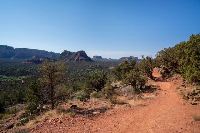
Brower Creative and The Sedona Chamber of Commerce & Tourism Bureau
If hiking around an airport sounds anything but appealing, then you haven’t been to Sedona Airport, which is perched on a flat mesa 500 feet above the city. The relatively flat trail and open views make this trek a must. The loop is 3.3 miles and Hermen notes it's “easy to find and high above it all. It's a great hike at sunrise or sunset to catch the light on the rocks.”
Wilson Mountain Trail
The Wilson Mountain trailhead is one of the easiest to reach (it’s right off 89A), but the trek itself is rated as difficult and it's more than 11 miles long. If you’re up for the challenge, Hermen recommends starting early. “The elevation gain and perspective from high atop Sedona make it one of my favorite hikes at sunrise,” he says.
For more Travel & Leisure news, make sure to sign up for our newsletter!
Read the original article on Travel & Leisure.

