Amazing aerial images of the world's most extreme weather events
Natural spectacles from up high

NASA images/Shutterstock
We've all been caught in torrential rainstorms and woken to see the streets outside coated in a blanket of snow, but the world's weather is even more wonderful and powerful when seen from above in pictures. From devastating droughts to icy lakes and extreme weather events, we take a look at some global meteorological wonders from the skies.
Storm surge, Tuvalu, South Pacific

Mario Tama/Getty Images
Storms are becoming more frequent and intense in the South Pacific as a result of global warming, threatening low-lying islands such as the Tuvalu archipelago, one of the most vulnerable nations in the world to climate change. Here, trees have been felled after a storm swept onto an islet in the Funafuti atoll in November 2019. Rising sea levels, tidal flooding, storm surges and coastal erosion are a very real threat to the everyday life of the 11,000 people who call Tuvalu home.
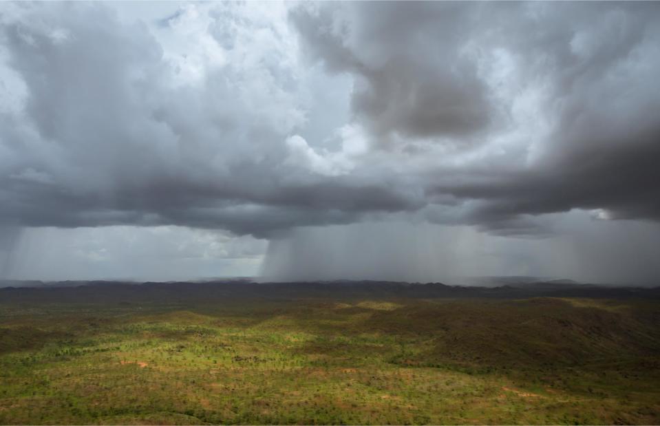
Wet season, the Kimberley, Western Australia, Australia
Philip Schubert/Shutterstock
Australia’s rugged Top End has a tropical monsoon climate with just two distinct seasons: wet and dry. The wet season stretches from November to April and is generally hot, humid and unpredictable. The beginning of the wet season, known as the "build up", brings about short and violent thunderstorms and intense rainfall like this localized storm that was captured near Warmun in the remote Kimberley region of Western Australia.
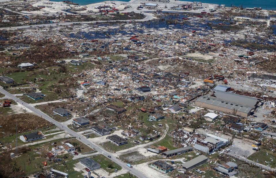
Hurricane Dorian, Bahamas, the Caribbean
ADAM DELGIUDICE/AFP/Getty Images
There can be no doubting the terrifying power of nature when seeing the destruction wreaked upon the Bahamas by Hurricane Dorian in September 2019. Pictured here is Freeport on Grand Bahama after the Category 5 hurricane slammed the island nation with high winds, lashing rain and storm surges in what was the worst storm to hit the country since records began. The hurricane pummeled the country for three consecutive days with the worst-hit island being Great Abaco.
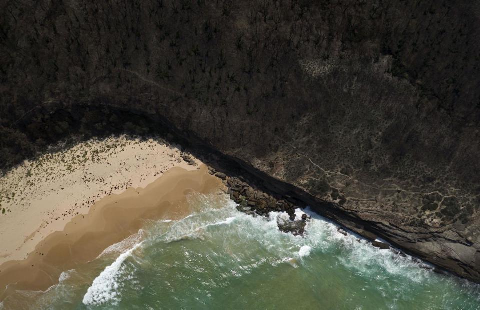
Wildfires, New South Wales, Australia
Brook Mitchell/Getty Images
To get a real sense of the scale of Australia’s worst ever bushfire season you need a bird's-eye view. This aerial image shows torched trees stretching along the idyllic shoreline of Pretty Beach on New South Wales’ south coast. Scorching temperatures and strong winds led to intense and sweeping blazes that devastated parts of New South Wales, Victoria, Queensland and South Australia in late 2019 and January 2020.
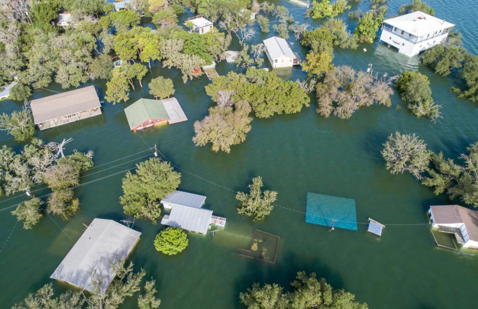
Heavy rain and flooding, central Texas, USA
Roschetzky Photography/Shutterstock
Central Texas is no stranger to heavy rain and flash flooding with major cities such as Austin often feeling the effects. In fall 2018, the region experienced devastating floods, with its rivers dangerously swollen by rain and Lake Travis rising to a record 704 feet (215m). This overhead photo captures the destruction it caused with some homes entirely submerged in water. Other parts of the state were also affected in what was the highest rainfall Texas had faced since Hurricane Harvey in 2017.
Snow, the Dolomites, Italy

pio3/Shutterstock
The Dolomites in northern Italy are famed for their jagged peaks, emerald forests and some of Europe's best ski slopes. But this dramatic mountain range on the border with Austria also makes for a stunning road trip. The Great Dolomite Road strikes through the peaks, spooling out for 86 miles (138km), with plenty of hairpin bends along the way. The forest-flanked road is captured here in the depths of winter, snaking its way through a snowy forest.
Storm Dennis, Hereford, UK
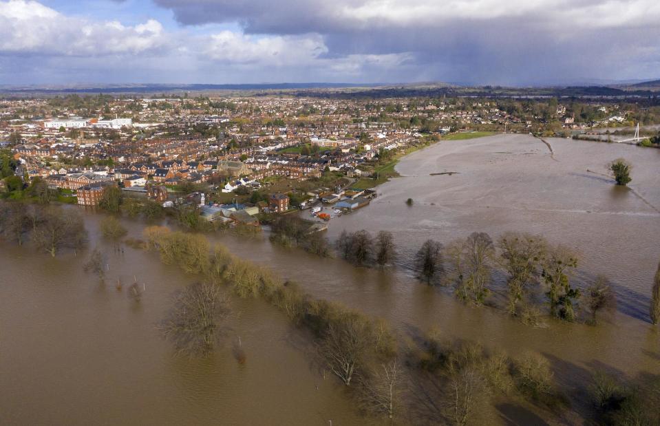
Christopher Furlong/Getty Images)
Storm Dennis menaced parts of the UK in mid February this year, just after Storm Ciara assailed the country with strong winds and heavy rain. The strongest winds were recorded at Aberdaron in Wales, where gusts of 91 miles per hour (146km/h) were recorded. Major flooding also occurred when the River Wye, pictured here, reached its highest ever recorded level and burst its banks. Hereford and surrounding villages were inundated with flood waters.
Fog, San Francisco, California, USA

Radoslaw Lecyk/Shutterstock
The Golden Gate Bridge is San Francisco’s most famous landmark. But it's sometimes a little difficult to make out. Fog often cloaks the rust-red bridge, particularly throughout the summer months. The thick advection fog usually rolls into the bay early in the morning, occurring when the hot inland air rises and heavier cold ocean air rushes in to replace it. The fog is so famous that it's even been given its own name, Karl, and Twitter account.
Low clouds, Yellow Mountain, China

Obbchao/Shutterstock
With its spiky rock formations and gnarled ancient pine trees, China's Yellow Mountain (Huangshan) is a mesmerizing sight whatever the weather. But it looks particularly magical when a sea of clouds collects around its pinnacles. Here the phenomenon is captured from up high, with just its sharp peaks cutting through the cloud cover. Mysterious mists and billowing clouds are common in this UNESCO Global Geopark, which is located in the humid subtropical monsoon climate zone of the Anhui Province.
Storms and fog, Chicago, USA
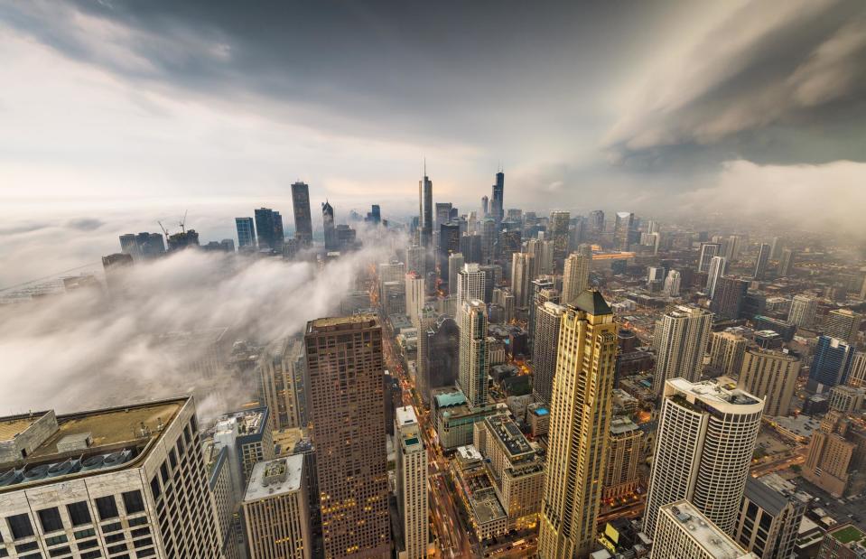
Sean Pavone/Shutterstock
Affectionately dubbed the Windy City, Chicago is well known for its bone-chilling winds but it's also prone to storms and fog. True to form, this aerial image shows the sky turning dark as foreboding storm clouds spread across the city and fog creeps up its high rises. Fog often rolls between the city's buildings in spring and summer as moist air sits above the relatively cool water of Lake Michigan and generates fog.
Hurricane Florence, North and South Carolina, USA
NASA images/Shutterstock
Hurricane Florence wreaked havoc across both North and South Carolina in 2018, causing a forceful storm surge of nine to 13 feet (3–4m) that led to catastrophic flooding along with rainfall of up to 30 inches (76.2cm). The hurricane, which was Category 1 at landfall, also spawned additional deadly tornadoes which tore through the state of Virginia. Here, NASA captures Florence’s brute force from above.
Lightning, Haiti, the Caribbean
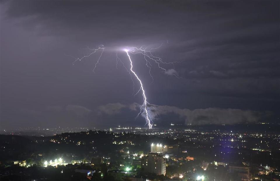
Hector Retamal/AFP/Getty Images
Lightning is one of nature’s most electrifying spectacles, especially when seen from above. In November 2018, an intense electrical storm generated giant streaks of lightning in the skies of Port-au-Prince, Haiti’s capital city. This aerial photo captures the powerful phenomena up close. The Caribbean is prone to spectacular thunderstorms, which are formed by the upward movement of warm and humid air.
Snow, Neman River, Belarus/Lithuania
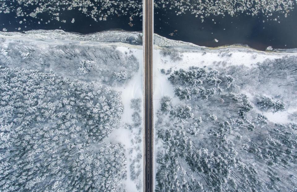
Mantas Ore/Shutterstock
The Neman River meanders through eastern Europe, rising in Belarus and flowing through neighboring Lithuania before joining the Baltic Sea. Flanked by trees, the 582-mile-long (937km) river is an attractive scene up close but even more impressive from the sky – especially in winter when its forested banks are dusted in snow and ice can form on its flowing waters. This symmetrical snap shows a straight road cutting a route across the frigid waterway.
Sandstorm, Tynemouth, UK
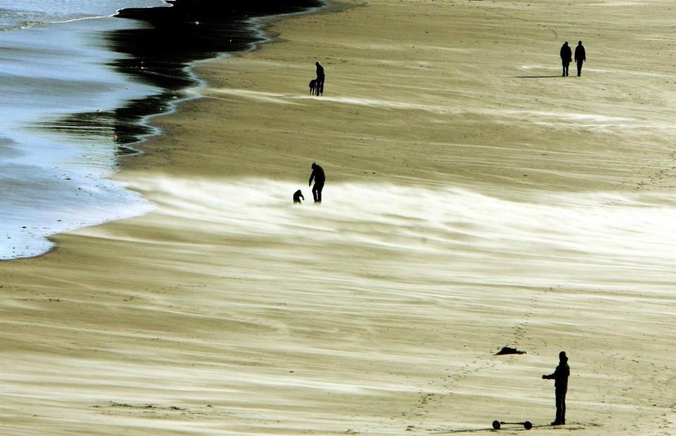
Owen Humphreys/PA Archive/PA Images
The UK is not usually known for its sandstorms, but beachgoers were blasted with a freak sandstorm as gale-force winds swept through northeast England in November 2007. Wind speeds reached up to 70 miles per hour (113km/h), battering the town of Tynemouth and causing traffic accidents and significant damage to buildings. In this image, determined beachgoers struggle stoically against the strong winds.
Dust storm, Alaska, USA
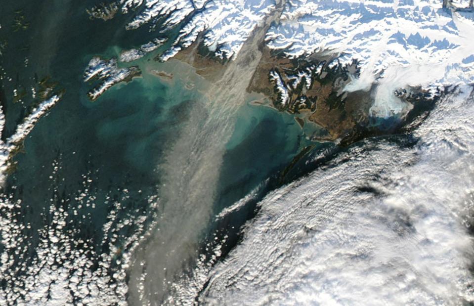
NASA Goddard/Flickr/CC BY 2.0
Alaskan dust storms are most common in the fall, when river levels are at their lowest and strong winds are frequent. They’re caused by glaciers grinding against underlying bedrock – this action forms a kind of silty powder much like sand. The fine substance then collects in rivers and lakes, eventually making its way onto banks and deltas, where it is whipped up by the wind. The result is a swirling dust storm like this one pictured by NASA.
Drought, Mekong River, Thailand
Zhang Keren/Xinhua News Agency/PA Images
With no sign of the critical monsoon rains and the Mekong River's water levels falling far below the usual monthly average, Thailand was on the edge of experiencing one of its worst droughts in a decade in 2019. Reservoirs had dried out and farmers' fields were left parched as the drought affected vast swathes of the country. This photo of the Mekong River was captured in Ubon Ratchathani in July 2019. With the monsoon rains arriving late and departing three weeks earlier, water levels in the Mekong River dropped to their lowest in more than 100 years.
Snow, Gurnee, Illinois, USA
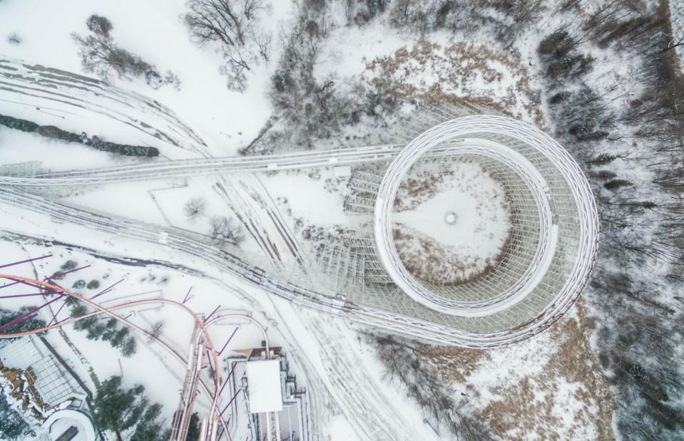
Amazing Aerial/Zuma Press/PA Images
Usually packed with hordes of thrill-seekers and swirling with the vibrant colors of roller coasters in motion, theme parks take on a whole new dimension when they lie blanketed under a layer of white snow. This still and snow-covered coaster and its icy tracks were snapped at Six Flags Great America in Gurnee, Illinois after a heavy snowstorm. The unusually peaceful scene has a different kind of magic.
Heavy rain and flooding, Yangzhou, China
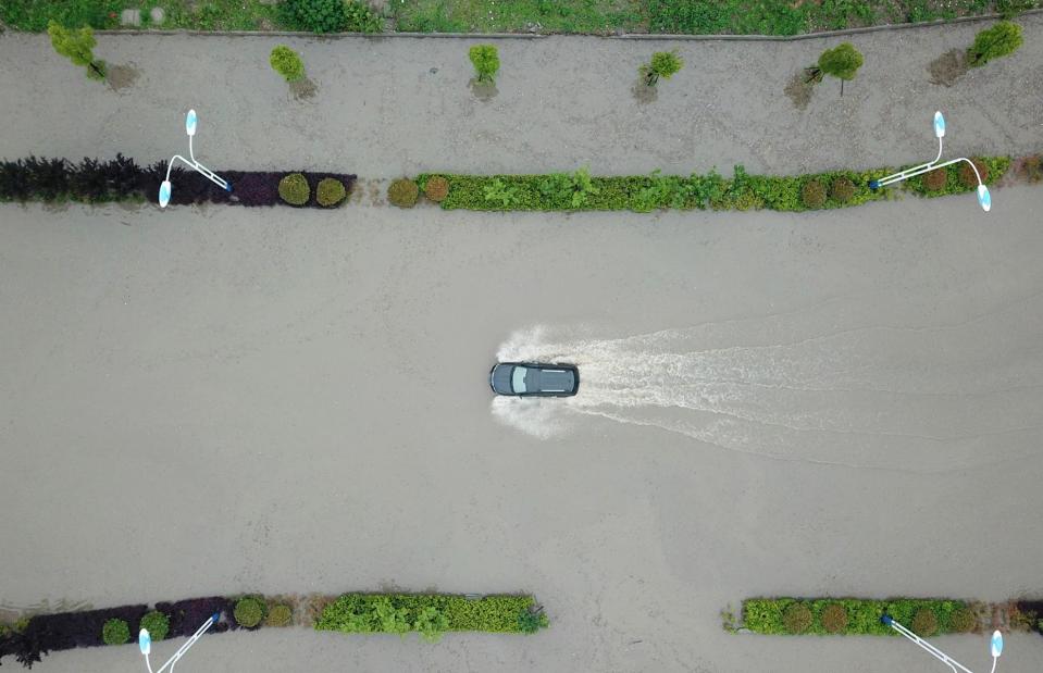
AFP/Getty Images
The city of Yangzhou in China's Jiangsu province, which straddles the Grand Canal north of the Yangtze River, has a subtropical monsoon climate with approximately 45% of its annual rainfall coming down in the summer months. The rainy season typically lasts from June until July, although Yangzhou experienced particularly heavy rains and flooding in May 2018. Here a car attempts to navigate the city's dangerously waterlogged roads.
Hailstorm, Guadalajara, Mexico
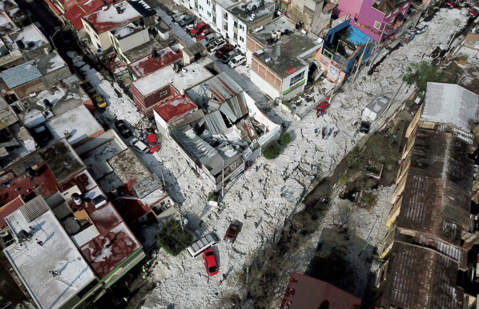
ULISES RUIZ/AFP/Getty Images
A steamy Mexican summer was in full swing in the populous city of Guadalajara, when a freak hailstorm left parts of the city buried under more than four feet (1.5m) of ice in 2019. Vehicles were buried, hundreds of homes and businesses were damaged and trees were felled by the battering hail. The devastating aftermath can be seen in this bird's-eye photo that was captured at the end of June.
Snow, nr Sottens, Switzerland

FABRICE COFFRINI/AFP/Getty Images
With its high peaks, glacial lakes and high alpine meadows, Switzerland is a stunner in the depths of winter. You’re spoiled for choice when it comes to gorgeous snowy scenes, and this icy aerial shot doesn't disappoint. The photo, showing a crossroads slicing through fields thick with virgin snow, was taken near Sottens in the canton of Vaud in western Switzerland.
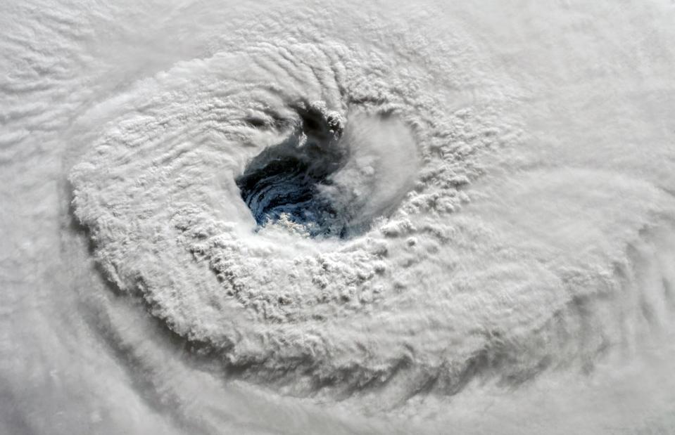
Hurricanes, Hawaii, USA
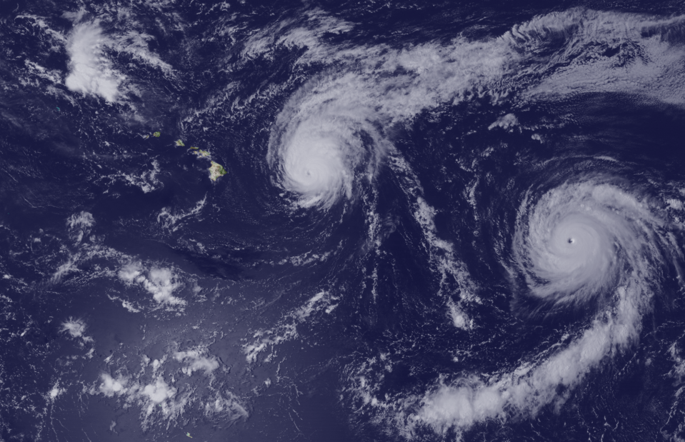
NASA Goddard/Flickr/CC BY 2.0
While these swirling Catherine wheels of cloud might look beautiful from above, hurricanes are deadly when they hit on land. This aerial image, taken by NASA in August 2015, shows three hurricanes – Kilo, Ignacio and Jimena – surrounding the Hawaiian archipelago ominously. The event represented the first time three Category 4 hurricanes existed simultaneously in the Pacific. Thankfully, the storms didn’t make landfall.
Rainstorm, Bangkok, Thailand
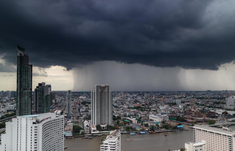
Guitarfoto Studio/Shutterstock
Think of Thailand and you likely think of balmy temperatures, blue skies and sunshine, but with its tropical climate it also experiences an intense rainy season and sometimes violent tropical storms. Its wettest months are typically from August to October when Bangkok experiences frequent and intense rainfalls, often causing parts of its waterways to flood. Here, in the height of summer, dark and moody clouds gather over the Thai capital and rain beats down in a steady stream.
Hurricane, Louisiana, USA
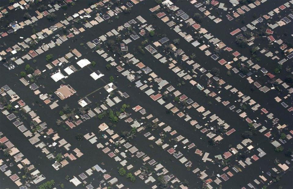
Dave Einsel/Getty Images
Hurricane Katrina was one of the deadliest hurricanes in US history and its costliest ever storm. More than 1,800 people were killed as a result of the Category 3 hurricane, most of them in Louisiana after the state experienced catastrophic flooding. Taken on 30 August 2005, this aerial shot shows the extensive damage to a neighborhood east of downtown New Orleans. After the storm caused a levee to break, a surge of floodwater began pouring into the low-lying city, going on to overwhelm many other levees and leaving the city submerged.
Storm, northern Italy
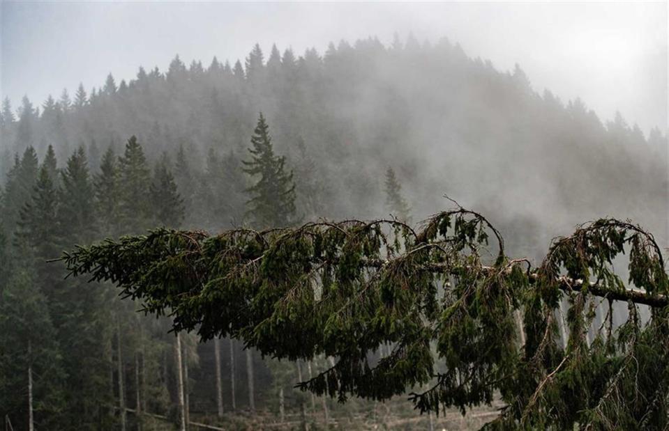
Vittorio Zunino Celotto/Getty Images
Violent winds reaching speeds of 118 miles per hour (190km/h) and heavy rains ripped through northeastern Italy in late October and November 2018. The worse affected regions were Trentino and Veneto, which experienced mudslides too. The stormy weather killed at least 17 people and an estimated 300,000 trees were felled or damaged, including large swathes of Trentino's famed Violins' Forest. In this photo a tree bows dramatically due to the force of the wind.
Heatwave, London, UK
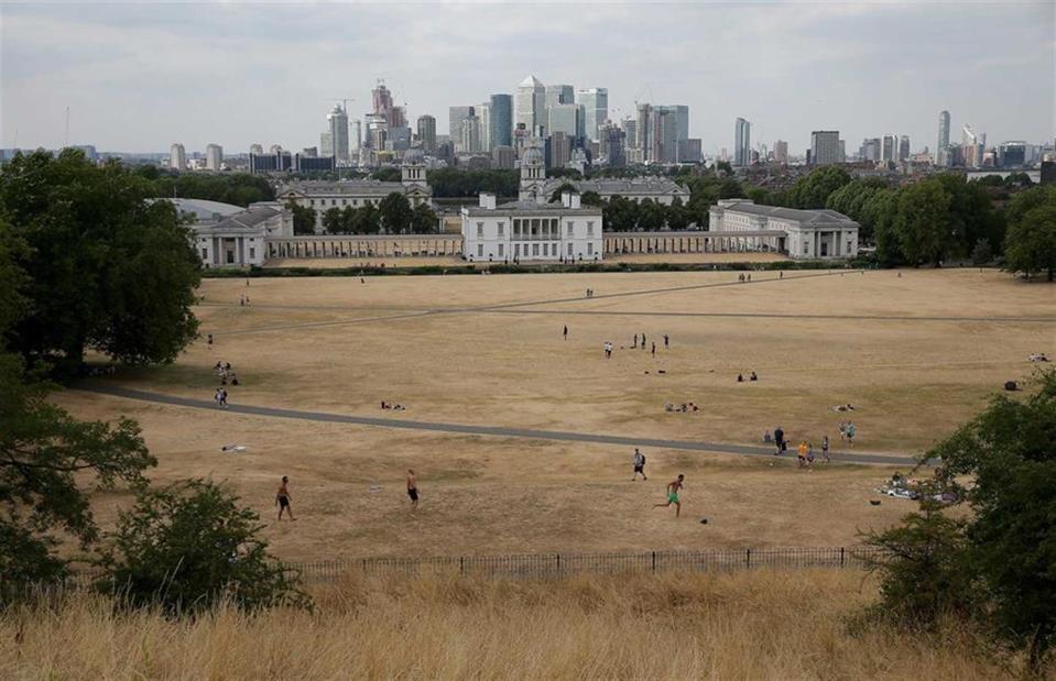
DANIEL LEAL-OLIVAS/AFP/Getty Images
The UK and other parts of northern Europe were gripped by an intense heatwave in the summer of 2018, which proved to be the joint-hottest summer on record. Here the effects of the prolonged hot weather can be seen as the usually lush Greenwich Park, one of the largest green spaces in southeast London, is left a sandy brown in July 2018.
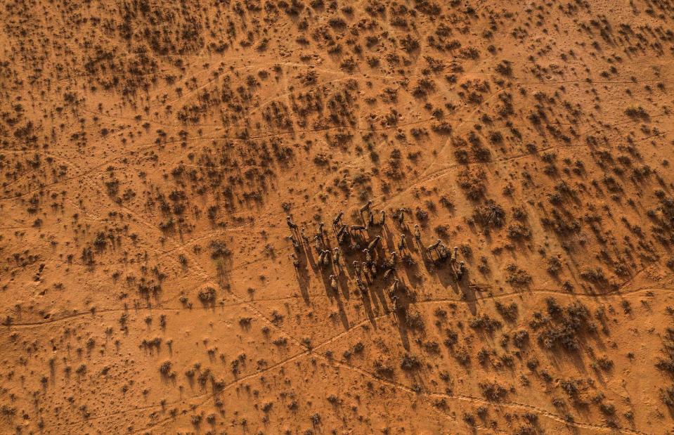
Drought, Northern Cape, South Africa
GUILLEM SARTORIO/AFP/Getty Images
A prolonged period of drought in the Northern Cape Province of South Africa has seen the region declared a disaster zone and devastated livestock and game. Several consecutive years of abnormally hot weather and below average rainfall have scorched grazing lands and dried up watering holes in what is now the worst drought in the country's history. This image shows a herd of buffalo on the arid terrain of Thuru Lodge Game reserve near Groblershoop in January 2020.
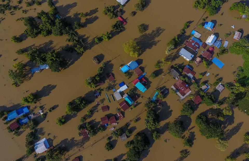
Floods, Ubon Ratchathani province, Thailand
KRIT PHROMSAKLA NA SAKOLNAKORN/THAI NEWS PIX/AFP/Getty Images
Dramatic rainfall in the northeastern provinces of Thailand caused major flooding in September 2019 and devastated many communities. The torrent, caused by two weather events (Storm Podul and a tropical depression that formed over the South China Sea), lashed the region for two weeks, resulting in flash floods and powerful mudslides. Pictured here is a flooded area in Ubon Ratchathani where residents had to be evacuated.
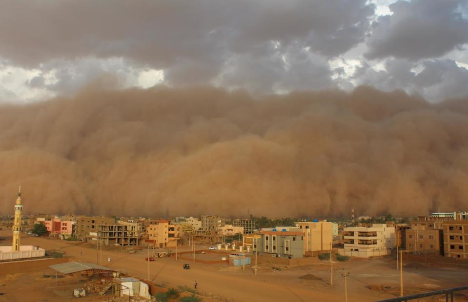
Sandstorm, Khartoum, Sudan
omer KOCLAR/Shutterstock
Haboob may sound like a comical mishap but these intense sand or dust storms are no laughing matter. They can wreak utter havoc when they take hold and are a relatively frequent occurrence in the driest parts of the world. Sudan's capital Khartoum is no stranger to this phenomenon, with whipped up sands regularly blasting the city, causing the sky to turn orange and leaving roads and buildings covered in a layer of sand. A particularly fierce sandstorm blew through the city in March 2018, forcing schools to shut and flights to be grounded.
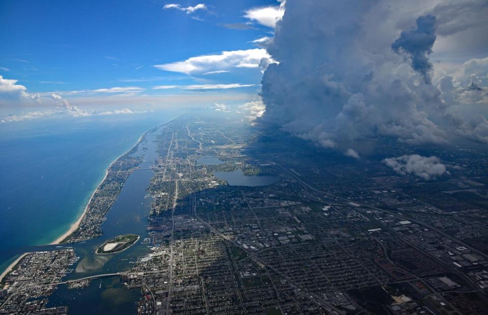
Thunderstorm, West Palm Beach, Florida, USA
Thomas Barrat/Shutterstock
With its tropical climate, the southern state of Florida certainly gets its fair share of storms and hurricanes, especially during the rainy season. Over the centuries there have been numerous destructive weather events across the state, most recently Harvey, Irma and Maria in 2017, Michael in 2018 and Category 5 Hurricane Dorian in 2019. Here, a thunderstorm's dramatic approach is captured from above as ominous clouds bowl in across the city of West Palm Beach.
Ice and snow, Chicago, Illinois, USA
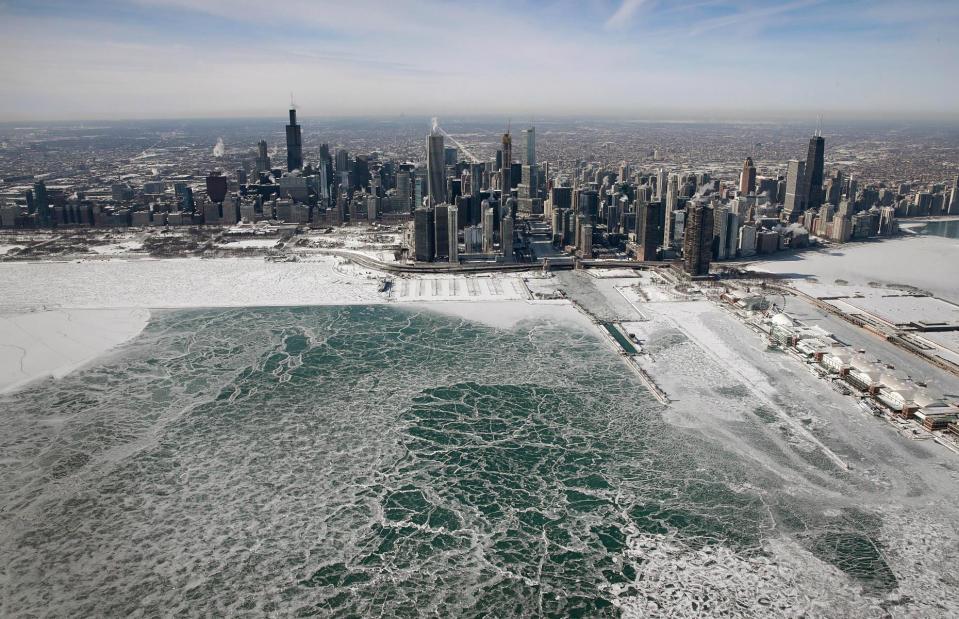
Scott Olson/Getty Images
A polar vortex blasted in from the Arctic in January 2019 and saw Chicago nicknamed "Chiberia" as it and other parts of the Midwest experienced teeth-chatteringly cold weather temperatures. The frigid temperatures, which plunged right down to -23ºF (-30.5ºC), resulted in several deaths, as well as total transport chaos and school closures. But the frozen Lake Michigan sat before the city's skyline made for a dazzling sight. A polar vortex is an area of low pressure and extremely cold air that swirls over from the Arctic.

