This AI Hunts Chinese Missiles Sites
"Hearst Magazines and Yahoo may earn commission or revenue on some items through these links."
A university team trained a deep learning algorithm to recognize surface-to-air missile sites in China and detect them among terabytes of digital imagery. The artificial intelligence program was able to find such sites not only just as accurately but faster than human beings. The news sheds insight into how AI could be used to supplement human intelligence specialists, helping them sort through thousands of square miles of satellite imagery to find the proverbial needle in a haystack.
Researchers at the University of Missouri wanted to design an algorithm to learn and detect patterns. They chose satellite imagery and obtained imagery of surface-to-air missile (SAM) sites. The university team then combined public data on 2,200 SAM sites worldwide with satellite imagery from DigitalGlobe, a company that purchases such imagery and sells it to the civilian market.
The University of Missouri AI could locate 90 confirmed SAM sites across a 55,923-square-mile swath of southeastern China about the size of North Korea, and was able to do so in 45 minutes. According to Wired, it normally takes a human being about 60 hours to scan all the imagery with the same level of accuracy.
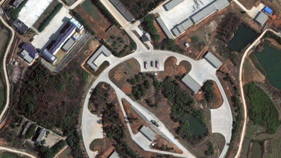
SAM sites, being military facilities, are always identical and follow set patterns ensure maximum defensive coverage. Typically a SAM site is star-shaped in order to cover all directions, with four or five surface-to-air missile launchers radiating from a central point where the control van, tracking and homing radars, and electrical generators are all located. Typically each location is surrounded by berms designed to prevent one missile launcher from being hit by debris in case another nearby launcher is destroyed.
SAM locations can also generally be predicted: SAMs are sited to protect important things, from military airfields to nuclear power plants, bridges, and factories. As a result, surface-to-air missile sites are easily spotted in satellite imagery. This People’s Liberation Army Air Force base, located across from Taiwan, was found in just two minutes in Google Earth. The base is home to F-7 fighters and what appears to be a crescent-shaped SAM site to the northeast. (In this case, the PLAAF would expect Taiwanese fighters and missiles to come from the east and a star-shaped configuration is unnecessary.)
The university’s research could be a boon for intelligence analysts whose work is often compared to drinking from a fire hose. The transparent amount of data available to analysts often exceeds their ability to properly analyze it. While the system isn’t perfect, it could allow analysts to ignore locations where an AI finds military facilities and concentrate their attention on areas where something should be but nothing obvious stands out. Camouflaged sites would be very difficult to locate—as long as the camouflage itself isn’t dressed in an identifiable pattern.
Read more at Wired.
You Might Also Like

