8 Amazing National Parks and Sites in Texas for Beautiful Views, Epic Trails, and Wildlife Spotting
Matt Munsell/Getty Images
There's no doubt that the Lone Star State is known for honky-tonks, barbecue, and plenty of wide-open spaces. Many of these wide-open spaces are managed by the National Park Service (NPS) and include vast mountains, deserts, canyons, raw shorelines, and dense forests with thousands of trails, animals, and plant life to discover. From the West Texas mountains to the East Texas bayous, and everything in between, here are eight of the best national parks and sites in Texas.
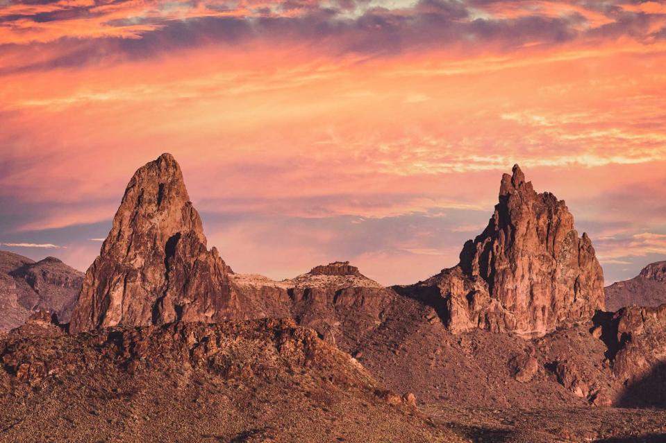
Big Bend National Park
Delaney Van/Getty Images
In southwestern Texas, more than 800,000 acres of mountains, desert, canyons, and the wild Rio Grande make up Big Bend National Park. Big Bend contains the most representative example of the Chihuahuan Desert ecosystem in the U.S., supporting more than 1,200 plant species, 11 amphibian species, 56 reptile species, 40 fish species, 75 mammal species, and 400-plus bird species. In fact, it contains more types of birds, bats, butterflies, ants, scorpions, and cacti than any other national park in the country.
Aside from excellent wildlife, the park is home to more than 150 miles of trails for day hikes and backpacking trips, with elevation changes ranging from 1,800 feet along the Rio Grande to almost 8,000 feet in the Chisos Mountains. You can also take the car down Ross Maxwell Scenic Drive, which offers scenic overlooks and jaw-dropping views of the Chihuahuan Desert, or hike the popular Lost Mine Trail and Window Trail for Instagram-worthy snapshots. For a truly unforgettable view, enjoy a kayak ride down the Rio Grande, winding your way through the surrounding canyons. Developed campgrounds and backcountry camping are both available, too.
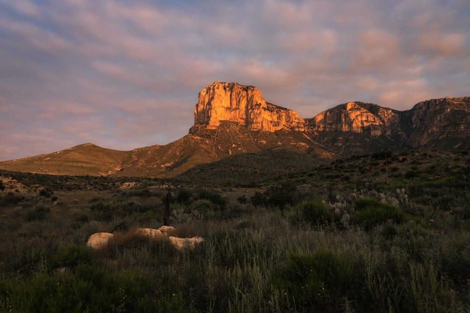
Guadalupe Mountains National Park
Jacob Bryant/EyeEm/Getty Images
Just below the New Mexico state line sits Guadalupe Mountains National Park, which consists of more than 86,000 acres of desert, dunes, mountains, canyons, the world's most extensive Permian fossil reef, and the four highest peaks in Texas. The park protects one of the Earth's best examples of an ancient marine fossil reef, as this region was actually a tropical sea about 265 million years ago during the Permian period. Crawling with marine life, the reef stretched about 400 miles along the shoreline. Once the sea evaporated, the reef was buried in sediment and mineral salts for millions of years until uplift exposed huge sections of the fossilized area.
Don't miss El Capitan, a 1,000-foot-tall limestone cliff, or choose an easy or strenuous hike along the 80-plus miles of trails. You can even spend a day hiking to the "Top of Texas" (a.k.a. Guadalupe Peak), which stands almost 9,000 feet above sea level and is the highest point in the state.
This fall, the park celebrates its 50th birthday, and it's one of the best places in the state to see fall foliage, which usually lasts from mid-October to mid-November. Numerous developed campgrounds are available, and backpackers can choose from 10 designated wilderness campsites. Just be sure to take some time to stargaze, as this remote destination allows visitors to see more than 11,000 stars and the Milky Way at night.
Related: The Best Small Towns in Texas
Padre Island National Seashore

Rebecca L. Latson/Getty Images
For a true look at a pristine, marine paradise, head to Padre Island National Seashore, the longest stretch of undeveloped barrier island in the world. The park protects 66 miles of coastline, dunes, and wind and tidal flats that provide ecosystems for numerous wildlife, including the Kemp's ridley sea turtle, the most critically endangered sea turtle species. These animals nest on the beach here from late April through mid-July, and it's one of the few places where people can see hatchlings make their way out into the shore to begin their lives. Hatchling releases usually take place from mid-June through August, and the public is welcome to watch them in the early morning hours.
Padre Island National Seashore is also one of the few remaining hypersaline lagoons in the world, and a favorite place for more than 380 bird species — almost half of all documented bird species in North America have been spotted here. Grab a pair of binoculars and see how many species you can count.
Looking for more water activities? Get a kayak or canoe and drift over the Laguna Madre, which has shallow water that's great for beginner and expert paddlers alike. If you find yourself at Padre Island National Seashore after a storm, be sure to do some beachcombing for beautiful sea shells. Campgrounds are open year-round, and there are no RV hookups anywhere in the park.
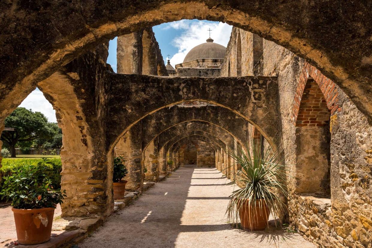
San Antonio Missions National Historical Park

Matt Munsell/Getty Images
Most people coming to San Antonio grab a quick picture in front of the Alamo and check it off their list. But the attraction is just a small part of San Antonio's five 18th-century Spanish colonial missions that make up San Antonio Missions National Historical Park. The missions are the only UNESCO World Heritage site in Texas, and were built beginning in the 1700s along the San Antonio River to introduce new religion, farming, and settled communities. The convenient Hike and Bike Trail along the San Antonio River connects all five missions, each being about two and a half miles from the next, making it easy to hop from mission to mission. Don't miss Mission San José. Known as the "Queen of the Missions," it's the largest of them all and was almost fully restored to its original design in the 1930s. Mission Concepción, which dates to 1755, is the oldest unrestored stone church in America, and visitors can see original frescoes in several rooms. Ranger-led programs are offered every day (except the first Wednesday of the month), including guided walks and talks.
Related: This Epic Texas Road Trip Visits Underrated Vineyards and Rolling Hills Blanketed in Bluebonnets
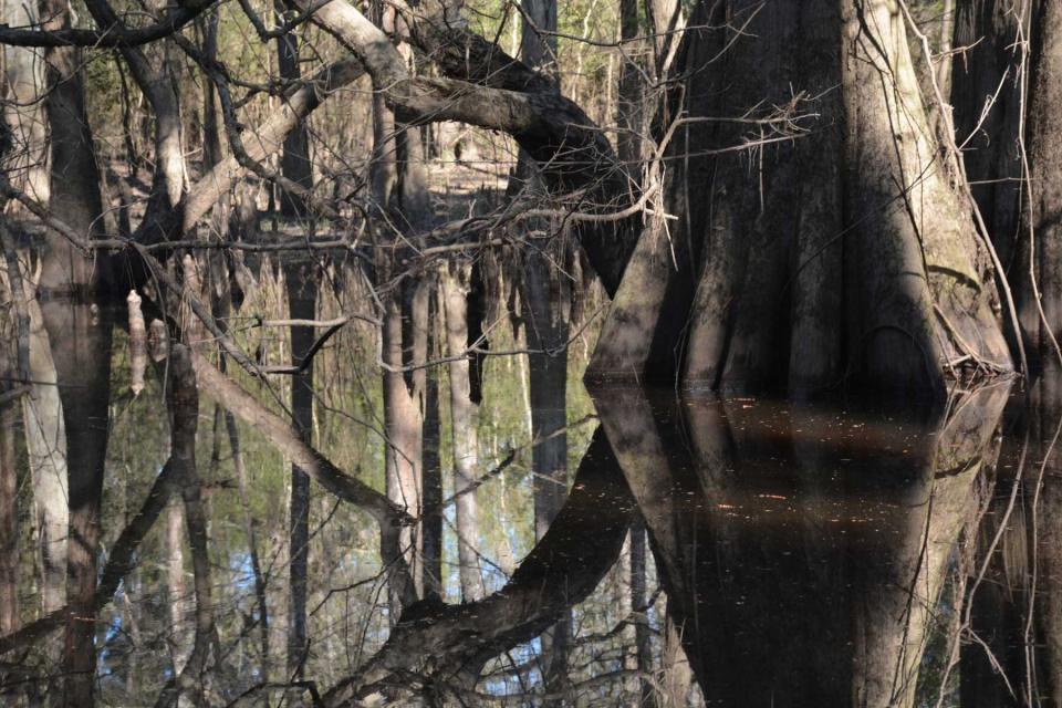
Big Thicket National Preserve
Getty Images
In this portion of southeastern Texas, nine different ecosystems — including longleaf pine forests and cypress-lined bayous — converge to make up Big Thicket National Preserve. Established in 1974, Big Thicket protects multiple habitats across 113,000 acres in the Piney Woods region, where hiking, paddling, and camping abound. There are approximately 40 miles of trails here, perfect for hiking and walking. Paddlers enjoy meandering their way through cypress sloughs, creeks, rivers, and bayous, as there are multiple access points providing different trip options and experience levels. Wade your way down three official Texas Paddling Trails, or join a ranger-led paddle trip. The Cooks Lake to Scatterman Paddling Trail along the Neches River offers plenty of bird sightings, including prothonotary warblers, ospreys, egrets, and swallow-tailed kites. Fishing opportunities are ample as well, as is wildlife viewing. See if you can spot some critters, including beavers, river otters, bats, opossums, armadillos, white-tailed deer, red foxes, bobcats, and even alligators. Backcountry camping is available throughout much of the park's lands and waterways.
Amistad National Recreation Area
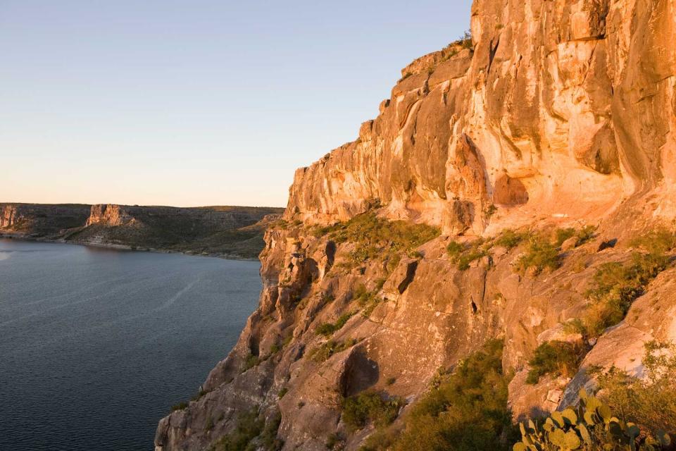
Robert Daemmrich Photography Inc/Corbis via Getty Images
Straddling the U.S.-Mexico border in Del Rio, Texas, Amistad National Recreation Area is known for water activities, camping, hiking, and historic rock art. With about 60,000 surface acres of water, Amistad is a haven for anglers, and pros have discovered that the Amistad Reservoir is a treasure chest full of largemouth, smallmouth, and striped bass; blue catfish; sunfish; and even alligator gar (all catch and release). Boaters also enjoy taking to the open water for skiing and sailing. An array of plants and animals — including white-tailed deer, cottontail rabbits, jackrabbits, and birds such as flycatchers, olive sparrows, and two types of tropical kingfishers — call the area home.
In the fall, thousands of monarch butterflies visit Amistad on their migration to Mexico, and numerous waterfowl species winter on the lake before heading back north in the spring. Perhaps one of the most interesting aspects of Amistad is the 4,000-year-old prehistoric Native American rock art paintings on shelter walls throughout the area. Panther and Parida caves are accessible by boat, depending on lake levels, or visitors can see the pictographs by foot. Several hiking trails are available, and Amistad offers five primitive campgrounds and backcountry camping by boat on undeveloped shorelines within the park.
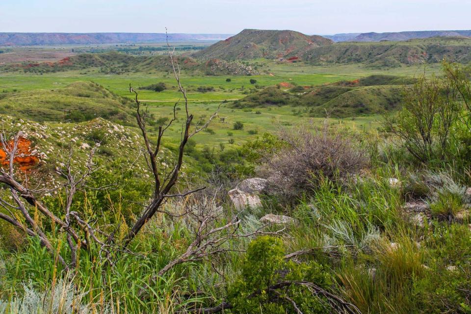
Alibates Flint Quarries National Monument
Getty Images
Around 13,000 years ago, this area in the Texas Panhandle was frequented by mammoth hunters as a source of flint for their tools. For centuries, the area was used by different Native American groups who employed the flint for knives, projectile points, scrapers, and other contraptions. The flint here is actually an agatized dolomite, coming from a 10-square-mile area and concentrated on about 60 acres in the Alibates Flint Quarries National Monument. More than 700 quarries exist where this flint was dug by hand, and tools made from Alibates flint have been found in places across the Great Plains and Southwest. Visitors here can see Alibates flint on display in the visitor center, or take a guided tour with a park ranger to learn about the Native Americans who used the flint thousands of years ago and see the quarry sites on top of one of the mesas. Ranger-led tours can also include viewings of the monument's petroglyphs carved into the dolomite as far back as 1100 A.D. Tours are available from April through October, and the monument is also a spectacular place to see wildflowers from spring to late fall.
Waco Mammoth National Monument
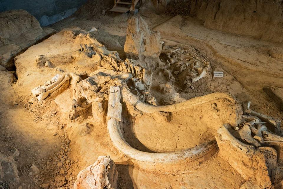
Arpad Benedek/Getty Images
In spring 1978, Eddie Bufkin and Paul Barron went searching for arrowheads and fossils near the Bosque River in Waco, Texas. They spotted a large bone jutting out of a ravine and removed it to take to Baylor University's Strecker Museum (now known as the Mayborn Museum Complex). Museum staff determined it was the femur bone from Mammuthus columbi, a now-extinct Columbian mammoth that lived in the Americas during the Pleistocene epoch. It stood about 14 feet tall and weighed approximately 20,000 pounds. The staff quickly put together an excavation team at the site, and between 1978 and 1990, the fossilized remains of 16 Columbian mammoths were found — a nursery herd that seemed to have died together in a single event. These fossils represent the nation's first and only recorded evidence of a nursery herd of ice age-era Columbian mammoths. Six more mammoths were excavated between 1990 and 1997, and the team also unearthed the remains of a Western camel, dwarf antelope, American alligator, giant tortoise, and the tooth of a young saber-toothed cat. It's still unknown how these animals perished, but one theory is a flash flood. Most of the fossils excavated after 1990 remain in situ here at Waco Mammoth National Monument, where visitors can take a guided 45-minute tour.
Amanda Ogle is a writer and editor born and raised in Texas. She frequently travels the state and country chasing stories, and covers travel, food and drink, sustainability, and other topics. Her most interesting Texas encounters to date include a bucket full of rattlesnakes, accidentally standing on an alligator in Lake Corpus Christi, and befriending a possum with a jar of beef fat. View all her work at amandaogle.com.

