6 scenic drives across the United States where you can get your fall foliage fix
Many a US roadway is nothing more than a clogged eyesore or an efficient but bland way to get from Point A to Point B.
But sometimes, roadways and natural beauty meet in a harmonious convergence where driving can be a delight and even more important than the destination. This can prove especially true in autumn with the changing of the leaves.
As for when to go, timing is everything for the perfect fall drive. If you want to optimize your chances of catching the leaves in various shades of orange, red, purple and gold at their peak, check out this US foliage predictor map.
Just remember peak leaf-viewing time might also mean peak traffic time; plan accordingly, especially for weekends.
As for where to go, here are six fantastic fall scenic drives scattered around the continental United States along with plenty of other things to see and do when you pull the car over.
M-119, Michigan
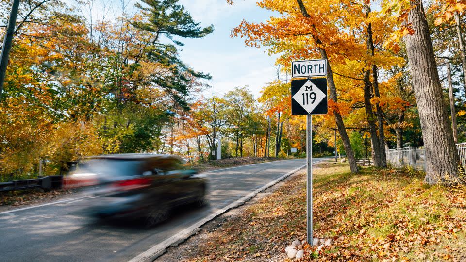
The Great Lakes make for great scenery. And the state of Michigan has shoreline on three of ‘em — Michigan, Huron and Superior — making for a dizzying number of choices. David Lorenz, vice president of Travel Michigan, helps narrow down the options, singing the praises of M-119, tucked away in the northwest of Michigan’s Lower Peninsula.
It’s affectionately known as the “Tunnel of Trees,” Lorenz said in an email to CNN Travel. The roadway starts just outside of the town of Harbor Springs and extends 21 miles (33.8 kilometers) north to Cross Village. It hugs the coast of Lake Michigan, showcasing “some of the state’s most brilliant fall foliage sure to delight any traveler,” Lorenz said.
Follow this map and turn the drive into a scenic loop of about 50 miles, or a one-hour and 15-minute drive.
Along the route or nearby:
• Travel Michigan said Thorne Swift Nature Preserve in Harbor Springs is a great stop to get fall foliage photos.
• Good Hart General Store has an early 1900s era charm.
• No fear of heights? The pedestrian SkyBridge Michigan at Boyne Mountain Resort is 1,200 feet (366 meters) long and 118 feet high. It’s about 26 miles south of Harbor Springs.
• Enjoy the 44th Annual Apple Fest in Charlevoix, about 40 minutes southwest of Harbor Springs. The festival takes place October 13-15 this year.
Find out more about the M-119 here.
Salmon River Scenic Byway, Idaho
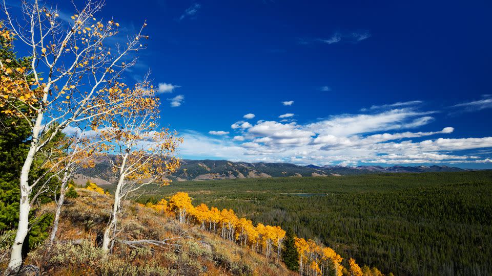
“Was that a moose?” “Did I just see an elk?” You and your companions might be asking such questions on the Salmon River Scenic Byway, suggested by Laurie McConnell, the senior tourism communications specialist at Visit Idaho.
This 161-mile byway “goes through some of the most rugged and remote country in the Lower 48, following the Salmon River through the Salmon and Challis national forests and provides access to jaw-dropping outdoor opportunities,” McConnell said in an email.
As for visuals, “Large stands of aspen show off with fall colors in burnt yellowy gold, but expect other trees to show off with red, orange, and caramel,” she said.
Along the route or nearby:
• The Sacajawea Interpretive, Cultural and Educational Center is the perfect place to learn about the original inhabitants of the region. (McConnell calls it a “can’t-miss” stop.)
• Land of Yankee Fork State Park features the ghost towns of Custer, Bayhorse and Bonanza. And it administers Challis Hot Springs on the banks of the Salmon River.
• Redfish Lake is the largest one in the Sawtooth National Recreation Area. Come here for nature viewing, hiking, fishing – and swimming if you can handle the cold water!
Find out more about the Salmon River Scenic Byway here.
Appalachian Highlands Scenic Byway, Alabama
If you thought Appalachian beauty petered out in northern Georgia, this scenic byway in the northeastern part of this Deep South state will prove you delightfully wrong.
Its 80 miles is hilly and curvy in places, “but overall, it is not a white-knuckle drive,” said Jo Jo Terry, digital marketing strategist with the Alabama Tourism Department. “Fall colors will be more prevalent on the northern part of the trail. The scenery is beautiful all along the trail.”
Drivers will find lush vegetation, interesting geologic formations and quaint communities along the route.
Along the route or nearby:
• Cheaha State Park, on the southern end of the byway, is home to the highest point in Alabama and is known for its beautiful, panoramic views, Terry said.
• DeSoto State Park, on the northern end of the byway, features waterfalls and has hiking, camping and bird watching among its activities.
• Mentone is an arts and crafts community about 10 minutes from DeSoto State Park. The “Wildflower Café is a delicious and magical place to eat,” Terry said.
• The Little River Canyon National Preserve contains “one of the deepest and most extensive canyon and gorge systems in the eastern United States,” according to the US National Park Service.
Find out more about the Appalachian Highlands Scenic Byway here.
High Road to Taos Scenic Byway, New Mexico

Who would ever want to leave charming Santa Fe? One thing that could lure you out of the state capital would be the High Road to Taos Scenic Byway, a 76-mile route north to the famous ski town.
Nicole Barker, media relations manager with the New Mexico Tourism Department, said via email that it takes about one hour and 45 minutes to drive without stops. But she suggested folks plan for a minimum of a half-day to fully enjoy the route. And what will you see?
“The route meanders through desert badlands, striking white geological formations and gold-drenched cottonwoods that line the Rio Nambe before winding through villages backdropped against Carson National Forest’s golden aspen groves and deep, dark evergreens blanketing the foothills of the Sangre de Cristo peaks,” Barker said.
Along the route or nearby:
• Santuario de Chimayó is an 1800s Catholic church that’s a National Historic Landmark. Barker said autumn is the perfect time to buy Chimayó red chile, which is only grown in the town of Chimayó.
• Folk-art gallery Eight Million Gods is In Truchas, an 18th-century Hispanic settlement turned artist enclave.
• Truchas Overlook “is also worth stopping for views of Quemado Valley and Truchas Peaks,” Barker said.
• “The High Road Art Trail makes it easy for visitors to locate studios and galleries,” Barker said. The High Road Artisans Studio Tour takes place in September 16-17 and 23-24.
Find out more about the High Road to Taos Scenic Byway here.
Mohawk Trail Scenic Byway, Massachusetts

Massachusetts and fall drives go hand-in-hand. The 69-mile Mohawk Trail Scenic Byway passes through three counties in northwestern Massachusetts, says Peter Tomyl, president of the Mohawk Trail Association – Regional Tourism Council, and fall is one of the best times to go “as vibrant hues of orange, red and yellow dance along the skyline passing by.”
“How many stops along the way visitors choose to make determines exactly how long the drive will be,” he said in an email.
“Large portions of the route wind through hills lined with lush forest landscapes [and] Berkshire Mountain climbs,” he said, adding that it passes through “quaint Massachusetts towns, passing by sprawling farmlands and a vast array of incredible restaurants, breweries, coffee shops, and historic landmarks.”
Along the route or nearby:
• Hairpin Turn in North Adams is “one of the most popular destinations in The Berkshires, Hairpin Turn is great to visit at sunset and offers breathtaking panoramic views,” Tomyl said.
• Mount Greylock State Reservation is the highest point in Massachusetts offering sweeping views.
• Susan B Anthony Birthplace Museum in Adams explores the life of the famous advocate.
• The Williams College Museum of Art in Williamstown has more than 15,000 works and is free.
Find out more about the Mohawk Trail Scenic Byway here. Parts of Massachusetts have had heavy rainfall and flooding recently. Check local forecasts and driving conditions before you head out.
Blue Ridge Parkway, North Carolina and Virginia
This splendid, curving road threads its way through the Blue Ridge Mountains. It starts in Virginia and continues southwest into North Carolina, and the total length is 469 miles (755 kilometers).
The parkway is free to use and open 24 hours a day unless portions are closed by things such as weather or landslides. It’s free of all commercial clutter – no billboards and businesses in sight.
You don’t have to tackle the whole thing unless you want a really big trip; just carve out a portion and drive that.
Along the route and nearby:
• In Virginia, the automotive and travel club AAA suggests that you pull off and enjoy Mabry Mill at milepost 176, where Ed Mabry and his wife, Lizzy, ground corn and sawed lumber for three decades. Also check out the Blue Ridge Music Center at milepost 213.
• In North Carolina, see what life was like for the Cherokee at Oconaluftee Indian Village at milepost 469.1.
• Also in North Carolina, explore the tallest peak east of the Mississippi at Mount Mitchell State Park or check out Biltmore Estate, which looks regal in autumn.
Find out more about the Blue Ridge Parkway here.
For more CNN news and newsletters create an account at CNN.com

